Calçoene
| Calçoene | |||
|---|---|---|---|
| Municipality | |||
| Município de Calçoene | |||
 Calçoene megalithic structures | |||
| |||
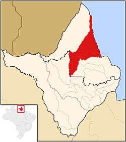 Location of Calçoene in the State of Amapá | |||
 Calçoene Location of Calçoene in the State of Amapá | |||
| Coordinates: 02°29′52″N 50°56′56″W / 2.49778°N 50.94889°WCoordinates: 02°29′52″N 50°56′56″W / 2.49778°N 50.94889°W | |||
| Country |
| ||
| Region | North | ||
| State |
| ||
| Founded | December 22, 1945[1] | ||
| Government | |||
| • Mayor | Lindoval Santos do Rosario (PSC) | ||
| Area | |||
| • Total | 14,269.258 km2 (5,509.391 sq mi) | ||
| Elevation | 3 m (10 ft) | ||
| Population (2010) | |||
| • Total | 8,964 | ||
| • Density | 0.63/km2 (1.6/sq mi) | ||
| Time zone | UTC-3 (UTC-3) | ||
| HDI (2010) | 0.643 – medium | ||
| Website | www.calcoene.ap.gov.br | ||


Calçoene is a municipality located in the east of the state of Amapá in Brazil. It is located on the Atlantic Ocean in the Amazon jungle basin near French Guiana. Calçoene covers 14,269 square kilometres (5,509 sq mi) and has a population is 8,964.[1] The name Calçoene is a corruption of "Calço N" (North Wedge, one of four mining zones defined by the Brazilian Government at the beginning of the 20th century).[2]
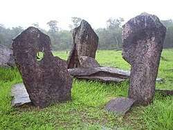
Calçoene was home to a Russian émigré colony in its area in the first decades of 20th century. The city has the highest rainfall of any in Brazil, with an annual average of 4,165 millimetres (164.0 in). Calçoene is noted for its ancient megalithic observatory, often referred to as the "Amazon Stonehenge".[3]
Geography
Calçoene is bordered on the north and east by the Atlantic Ocean, to the south by the municipalities of Amapá and Pracuúba, and to the west by the municipalities of Oiapoque and Serra do Navio. Calçoene is 272 kilometres (169 mi) from the state capital of Macapá.[1] The municipality contains 23.23% of the 2,369,400 hectares (5,855,000 acres) Amapá State Forest, a sustainable use conservation unit established in 2006.[4]
Calçoene megalithic observatory
In May 2006, archeologists announced they had found a pre-colonial astronomical observatory, possibly 500 to 2,000 years old, near Calçoene. The age is based on pottery sherds on site that have been dated to 2,000 years old. The site is on a hill and has 127 large stones blocks of granite, each 3 metres (9.8 ft) high, and dug firmly into the ground. Archaeologist Mariana Petry Cabral of the Amapa Institute of Scientific and Technological Research (IEPA) said that the observatory has been designed to align with the winter solstice. Other agricultural societies also developed sophisticated ways to track important times in the solar calendar. At one time, researchers did not think any cultures in the Amazon Basin had developed such complexity as to build such a site. This has altered their thinking.[5]
See also
References
- 1 2 3 "Calçoene" (in Portuguese). Macapá: Governo do Estado do Amapá. 2011. Archived from the original on 2014-02-22. Retrieved 2014-11-18.
- ↑ Amapá Digital: Calçoene
- ↑ "Embrapa identifica cidade mais chuvosa do Brasil" (in Portuguese). Notícias Terra. 2014-12-05. Retrieved 2009-01-31.
- ↑ FES do Amapá (in Portuguese), ISA: Instituto Socioambiental, retrieved 2016-07-06
- ↑ Wolford, Ben (2006). "Brazilian Stonehenge discovered". London: BBC. Retrieved 2014-11-18.
External links
- 'Amazon Stonehenge' - Yahoo story
- Photos
- "Calcoene, the Brazilian Stonehenge", Archaeoastronomy, 14 May 2006
- IEPA information, Amazonia
Capital: Macapá | ||
| Amapá | 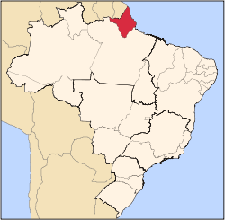 | |
| Macapá | ||
| Mazagão | ||
| Oiapoque | ||