Tartarugalzinho
| Tartarugalzinho | |
|---|---|
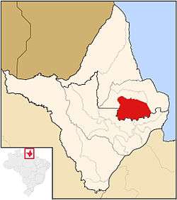 Location of Tartarugalzinho in Amapá | |
| Coordinates: 01°30′21″N 50°54′43″W / 1.50583°N 50.91194°W | |
| Country |
|
| Region | North |
| State |
|
| Government | |
| • Mayor | Rildo Oliveira (PMDB) |
| Area | |
| • Total | 6,712 km2 (2,592 sq mi) |
| Population (2010) | |
| • Total | 12,563 |
Tartarugalzinho (Big Tartarugal) is a municipality located in the east of the state of Amapá in Brazil. Its population is 12,563 and its area is 6,712 square kilometres (2,592 sq mi). Tartarugalzinho is located 230 kilometres (140 mi) from the state capitol of Macapá. It was established as a municipality on December 17, 1987.[1][2]
The municipality contains part of the 392,469 hectares (969,810 acres) Lago Piratuba Biological Reserve, a fully protected conservation unit created in 1980.[3] It also contains 7.64% of the 2,369,400 hectares (5,855,000 acres) Amapá State Forest, a sustainable use conservation unit established in 2006.[4]
References
- ↑ "Tartarugalzinho" (in Portuguese). Macapá, Amapá, Brazil: Governo do Estado do Amapá. 2011. Archived from the original on 2014-08-27. Retrieved 2014-06-05.
- ↑ "Tartarugalzinho" (in Portuguese). Tartarugalzinho, Amapá, Brazil: Prefeitura Municipal de Tartarugalzinho. c. 2013. Retrieved 2014-06-05.
- ↑ Unidade de Conservação: Reserva Biológica do Lago Piratuba (in Portuguese), MMA: Ministério do Meio Ambiente, retrieved 2016-04-27
- ↑ FES do Amapá (in Portuguese), ISA: Instituto Socioambiental, retrieved 2016-07-06
Capital: Macapá | ||
| Amapá | 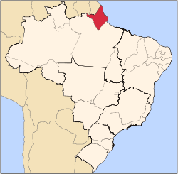 | |
| Macapá | ||
| Mazagão | ||
| Oiapoque | ||
| Wikimedia Commons has media related to Tartarugalzinho. |
This article is issued from
Wikipedia.
The text is licensed under Creative Commons - Attribution - Sharealike.
Additional terms may apply for the media files.