Barony of Galmoy
| Galmoy Gabhalmhaigh (Irish) | |
|---|---|
| Barony | |
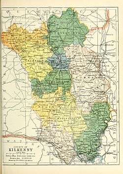 Baronies of County Kilkenny. | |
| Sovereign state | Republic of Ireland |
| County | Kilkenny |
Galmoy (Irish: Gabhalmhaigh) is a barony in County Kilkenny, Ireland.[1][2] It had been established by 1672. A barony is an historical geographical unit of land and Galmoy is one of 11 baronies that make up the county. While it is named after the village of Galmoy, today the chief town of the barony is Urlingford. It lies at the north-western corner of the county between Fassadinin to the east(whose chief town is Castlecomer), and Crannagh to the south (whose chief town is Freshford). It is surrounded on two sides by counties Tipperary to the west and Laois to the north. The M8 Dublin/Cork motorway bisects the barony. It is situated 121 kilometres (75 mi) from Dublin city and 131 kilometres (81 mi) from Cork city. It is currently administered by Kilkenny County Council.
History
Galmoy was once part of the ancient Gaelic Kingdom of Osraige. The main landholders in the barony were the Butlers. The Viscount Galmoye peers were descended from the 10th Earl of Ormond (see Piers Butler, 3rd Viscount Galmoye).
The O'Brophy's and Archdeacons were based in Galmoy.[3][4]
Galmoy was recorded in the Down Survey (1656),[5] and on Griffith's Valuation (1864).[6] It was in the Poor law union of Urlingford.[7]
Towns, villages and townlands of the barony
Galmoy contains the towns of Urlingford, Johnstown, and Ballyragget, and the settlements of Crosspatrick, Galmoy, Gattabaun.[8] Galmoy contains the civil parishes of Erke, Aharney, Urlingford, Balleen, Borrismore, Coolcashin, Fertagh, Glashare, Rathbeagh, Rathlogan and Sheffin.[9] Knockmannon Cross Roads is located in Gowran.[10]
List of civil parishes
- Erke
- Aharney
- Urlingford
- Balleen
- Borrismore
- Coolcashin
- Durrow
- Fertagh
- Glashare
- Rathbeagh
- Rathlogan
- Sheffin
Some towns and villages
Legal context
Baronies were created after the Norman invasion of Ireland as subdivisions of counties and were used for administration. While baronies continue to be officially defined units, they have been administratively obsolete since 1898. However, they continue to be used in land registration and specification such as in planning permissions. In many cases, a barony corresponds to an earlier Gaelic túath which had submitted to the Crown.
Notes
- ↑ (Fiontar 2008, Gabhalmhaigh/Galmoy)
- ↑ (Tighe 1802, p. 4, Baronies)
- ↑ (Carrigan 1905, p. 21, Existing Civil Divisions or Baronies - Galmoy)
- ↑ Walsh, Dennis. "The Baronies of Ireland". ancestry.com. and Walsh, Dennis. "Barony Map of the Leinster Region". ancestry.com.
- ↑ Down Survey Project. "Galmoy Map". downsurvey.tcd.ie. The Down Survey Project.
- ↑ (Griffith 1864, Galmoy Search)
- ↑ (Parliament 1862, p. 962, Galmoy Barony)
- ↑ (Fiontar 2008, Galmoy Towns and Fiontar 2008, Galmoy population centres)
- ↑ (Fiontar 2008, Galmoy Civil Parishes)
- ↑ (Fiontar 2008, Knockmannon Cross Roads)
References
- Fiontar (2008). "Placenames Database of Ireland". logainm.ie. Department of Community, Rural and Gaeltacht Affairs of the Government of Ireland.
- Griffith (1864). "Griffith's Valuation". www.askaboutireland.ie.
- Parliament (1862). General alphabetical index to townlands and towns, parishes and baronies of Ireland.
- Carrigan, William (1905). The History and Antiquities of the Diocese of Ossory. Sealy, Bryers & Walker. ISBN 9785879206463.
- Tighe, William (1802). Statistical observations relative to the county of Kilkenny: made in the years 1800 & 1801. Printed by Graisberry and Campbell.
External links
- Fiontar (2008). "Placenames Database of Ireland". logainm.ie. Department of Community, Rural and Gaeltacht Affairs of the Government of Ireland.
- Walsh, Dennis. "The Baronies of Ireland". ancestry.com.
- Walsh, Dennis. "Barony Map of the Leinster Region". ancestry.com.
| | |
| ||