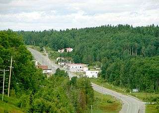
McGarry, Ontario
| McGarry | |
|---|---|
| Township | |
|
Township of McGarry Canton de McGarry | |
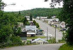 Virginiatown | |
| Nickname(s): V-Town | |
 McGarry | |
| Coordinates: 48°08′47″N 79°34′14″W / 48.14639°N 79.57056°WCoordinates: 48°08′47″N 79°34′14″W / 48.14639°N 79.57056°W[1] | |
| Country |
|
| Province |
|
| District | Timiskaming |
| Government | |
| • Type | Township |
| • Reeve | Clermont Lapointe |
| • Federal riding | Timmins—James Bay |
| • Prov. riding | Timiskaming—Cochrane |
| Area[2] | |
| • Land | 86.72 km2 (33.48 sq mi) |
| Elevation[3] | 327 m (1,073 ft) |
| Population (2011)[2] | |
| • Total | 595 |
| • Density | 6.9/km2 (18/sq mi) |
| Time zone | UTC-5 (EST) |
| • Summer (DST) | UTC-4 (EDT) |
| Postal code | P0K 1X0 |
| Area code(s) | 705, 249 |
| Website |
www |
McGarry is an incorporated township in Timiskaming District in Northeastern Ontario, Canada.[1]
The township includes the communities of Virginiatown and Kearns. It is situated on the border with Quebec to the east, along Highway 66 between Kirkland Lake and Rouyn-Noranda. The northern border of the township forms part of the border between Timiskaming District and Cochrane District. Highway 66 was rerouted in 2017 due to concerns of collapse due to aging mine shafts under the existing road[4].
J.T. Kearns (for whom the village was named) staked a claim in 1907, which became the Chesterfield Gold Mines (1938-1952). An 854-metre shaft connected 20 levels, and its 500-ton stamp mill produced a total of 458,880 ounces of gold. Virginiatown and North Virginiatown were built to house the Kerr Addison workers. Kerr Addison Gold mines started in 1936, and employed 1,456 people by 1959. Annual production was 500,000 ounces of gold from 1957 to 1961, and in 1960, produced the most gold in the Western Hemisphere. The 10,000,000th ounce of gold was produced in 1982. However, production reduced to 47,211 ounces in 1984 from a workforce of 329. The renamed Kerr Mine produced 15,350 ounces in 1993, and 22,000 ounces in 1994.[5]
History
In 1906[6], the discovery of silver deposits in Cobalt began slowing down forcing prospectors and miners to venture further north in search of their dreams. Some traveled the water systems up the Blanche River to Tomstown by steamboat, challenged the portages to Wendigo Lake (which took a better part of a day) and courageously braved the river with nine portages to "Larder Lake". Some traveled another 25 miles fighting the underbrush and many carry-overs.
The fall of 1906 gold was found on the northeast arm of Larder Lake (Virginiatown) by Dr. Robert Reddick. Word spread quickly setting the stage for a new township (McGarry) and the beginning of a gold rush for this area.
Tom Pearl built a trading post near the narrows of Larder Lake which the locals today, fondly refer to as "Pearl Beach" in his memory.
In 1910, a dentist from Toronto, Dr. George A. MacKay, with the financial aid from his brothers, bought up claims as Tonene Old Indian Mining Company. The ambitious Dr. McKay wooed prospective shareholders from Toronto transporting them in luxurious train coaches. He successfully sold many shares that year to enthusiastic investors enabling him to buy even more claims. Included in these claims were two claims that two medical doctors, Louden and Addison along with Hugo Kerr (manager of a Cobalt mine) had owned.
Dr. MacKay was very focused in finding his treasure of gold and with some struggles, coupled with pressure from his stakeholders, by the time the year 1937 rolled around, Chesterville and Kerr Addison mines were in full production attracting people from all over in search of their dreams and forming two economically booming towns Virginiatown and Kearns. Now combined to be the Township of McGarry.
Economy
The McGarry economy has historically been supported by the mining industry, and continues to be today. The Armistice Gold mine was purchased by Bonterra Resources from Kerr Resources in 2016 [7], and gold exploration and modelling is currently being done to update the resource to a 43-101 Compliant Resource[8].
Gold Candle Ltd. and investors purchased the old Chesterfield Gold Mines and Kerr Addison Gold Mines property in 2016 [9], and are currently conducting a feasibility study and gold exploration with Canadian Exploration Services Limited (CXS Ltd.)[10] on the old Chesterfield Gold Mines and Kerr Addison Gold Mines property.
Current small businesses being operated out of McGarry are[11]:
- Bonterra Resources
- Armstrong Transportation Services
- Cheminis Lodge
- H.R. Contracting & Equipment LTD.
- Desjardins Credit Union
- Godin Enterprises
- Guy's Service Station
- Income Tax Service
- Min Com Cambridge INC.
- JCA Automotive
- River Valley Rooms & Restaurant
Tourism
Summer
Larder Lake
Being situated on Larder Lake, and being home to large amounts of anglers, the McGarry Lions Club hosts an annual fish derby consisting of prizes for the largest pike, trout, and pickerel. There are also events for children, including catfish mini-derby and fish fry.
With a playground and several docks and boat launches, McGarry is the perfect place for a family day on the lake, be it for tubing, skiing, or fishing.
Mount Cheminis
For the adventurous, there are hiking trails to take you to the summit of Mount Cheminis for a picturesque view of both McGarry, and the surrounding area.
Country Jamboree
Hosted annually on Labor Day Weekend, various country artists flock to the McGarry community center to play music and dance with family and friends.
Winter
Skiing
Located within minutes of the Kanasuta Ski Hill[12], McGarry is fantastic for those who enjoy the winter months.
Poker Run
Every winter the McGarry Volunteer FireFighters Association has a snowmobile poker run where many snowmobilers can unite, meet new friends, catch up with old friends and spend a fantastic day of snowmobiling with family and friends.
Demographics
| Historical population | ||
|---|---|---|
| Year | Pop. | ±% |
| 1991 | 1,139 | — |
| 1996 | 1,015 | −10.9% |
| 2001 | 787 | −22.5% |
| 2006 | 674 | −14.4% |
| 2011 | 595 | −11.7% |
| Source: [13] | ||
Private dwellings, excluding seasonal cottages: 284 (total: 360)
Mother tongue:[14]
- English as first language: 30.5%
- French as first language: 63%
- English and French as first language: 1.5%
- Other as first language: 5%
See also
References
- 1 2 "McGarry". Geographical Names Data Base. Natural Resources Canada. Retrieved 2014-05-19.
- 1 2 2011 Census Profile
- ↑ Elevation taken from Google Earth at geographical coordinates, accessed 2014-05-20.
- ↑ http://www.northernnews.ca/2015/10/02/ontario-investing-in-highway-66-at-virginiatown
- ↑ Barnes, Michael (1995). Gold in Ontario. Erin: The Boston Mills Press. pp. 33–37. ISBN 155046146X.
- ↑ https://www.mcgarry.ca/tourism-in-mcgarry-area/about-us
- ↑ http://kerrmines.com/bonterra-resources-acquires-larder-project-kerr-mines-consisting-two-gold-deposits-9-km-cadillac-larder-break/
- ↑ http://www.bonterraresources.com/projects/larder-project/
- ↑ https://cdn2.hubspot.net/hubfs/211718/docs/Gold_Candle_-_6-Supplementary_Application_Record_-_June_21_2016.pdf?t=1508443953287
- ↑ http://www.cxsltd.com/
- ↑ https://www.mcgarry.ca/businesses-in-mcgarry/local-businesses
- ↑ http://www.kanasuta.com/
- ↑ Statistics Canada: 1996, 2001, 2006, 2011 census
- ↑ "2006 Community Profile".
External links
- Official website
- Community profile (2008)
- Image of McGarry Township Building, circa 1953, from vtownhistory.org
- Historic Photos of Virginiatown & Kearns
Places adjacent to McGarry, Ontario | |
|---|---|
| City |  | |
|---|---|---|
| Towns | ||
| Townships | ||
| Village | ||
| Indian Reserves | ||
| Unorganized areas | ||
| Local services boards | ||
| ||