James, Ontario
| James | |
|---|---|
| Township (single-tier) | |
| Township of James | |
 | |
 James | |
| Coordinates: 47°42′38″N 80°20′22″W / 47.71056°N 80.33944°W[1]Coordinates: 47°42′38″N 80°20′22″W / 47.71056°N 80.33944°W[1] | |
| Country |
|
| Province |
|
| District | Timiskaming |
| Incorporated | 1909 |
| Government | |
| • Reeve | Terry Fiset |
| • Federal riding | Timmins—James Bay |
| • Prov. riding | Timmins—James Bay |
| Area | |
| • Total | 86.19 km2 (33.28 sq mi) |
| Population (2011)[2] | |
| • Total | 424 |
| • Density | 4.9/km2 (13/sq mi) |
| Time zone | UTC-5 (EST) |
| • Summer (DST) | UTC-4 (EDT) |
| Postal code | P0J 1G0 |
| Area code(s) | 705, 249 |
| Website |
www |
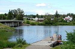
James is an incorporated township in the Canadian province of Ontario, located in Timiskaming District.[1][3] The primary community within the township is Elk Lake, which is located at the junction of Ontario Highway 65 and Ontario Highway 560.[4]
The township had a population of 424 in the Canada 2011 Census.[2]
Elk Lake Airport and Elk Lake Water Aerodrome are located here.
History
.jpg)

Elk Lake began as a mining boom town when native silver was discovered in James Township in 1906. Mining activity peaked between 1907 and 1913, when there were about thirty active mining properties in the area. The population at one point reached almost 10,000 people. By 1908 the town included six large hotels, many stores, warehouses, banks, lawyer's offices, a post office, a hospital and a Mining Recorder's Office. The town of Elk Lake was incorporated in 1909 as the Corporation of the Township of James. The Township's first Reeve was the famous athlete and prospector Jack Monroe.
Access to Elk Lake was initially only by motorboat via the Montreal River. By 1909 the road from Elk Lake to Charlton could be traversed by coach, although commercial steamers on the Montreal River continued to provide summer access from Latchford for most heavy equipment and freight. The steamboat era on the Montreal River lasted only a few years, ending when a branch of the Temiskaming and Northern Ontario Railway (now Ontario Northland Railway) was built into Elk Lake in 1913.
Commercial logging in the Temiskaming area dates back to the 1840s. In 1905, the Montreal River Pulp Concession, an area of 17,000 square miles (44,000 km2), was sold to J.R. Booth. From 1907 to 1923, Booth maintained a large pulpwood depot in Elk Lake. In the spring of 1930, Booth completed the last log drive on the Montreal River shortly after he sold his local interest to the E.B. Eddy Company.
The Indian Chute Generating Station was constructed on the Montreal River in 1923, 16 km (9.9 mi) north-west of Elk Lake.[5]
Today, Elk Lake's economy continues to be driven by a sustainable forest industry. The town also boasts a significant number of tourist camps and lodges offering excellent packages for the outdoor sports and nature enthusiasts.[6]
The 1,420-hectare (3,500-acre) Makobe-Grays River Provincial Park has protected the Makobe River since 1985.[7][8] This popular whitewater canoeing route flows into the Montreal River at Elk Lake.
Demographics
Population:[9]
- Population in 2011: 424 (2006 to 2011 population change: 2.4%)
- Population in 2006: 414
- Population in 2001: 467
- Population in 1996: 483
- Population in 1991: 524
Private dwellings, excluding seasonal cottages: 194 (total: 253)
Mother tongue:[10]
- English as first language: 49.4%
- French as first language: 45.8%
- English and French as first language: 2.4%
- Other as first language: 2.4%
In popular culture
Canadian songwriter Hayden Desser recorded an album entitled Elk-Lake Serenade.
See also
References
- 1 2 3 "James". Geographical Names Data Base. Natural Resources Canada. Retrieved 2017-01-03.
- 1 2 2011 Census Profile
- ↑ "James" (PDF). Geology Ontario - Historic Claim Maps. Ontario Ministry of Northern Development, Mines and Forestry. Retrieved 2017-01-03.
- ↑ "Elk Lake". Geographical Names Data Base. Natural Resources Canada. Retrieved 2017-01-03.
- ↑ "Indian Chute Generating Station". Ontario Power Generation.
- ↑ History of Elk Lake
- ↑ "Makobe-Grays River Provincial Park". Geographical Names Data Base. Natural Resources Canada. Retrieved 2017-01-03.
- ↑ "Makobe-Grays River". Ontario Parks. Retrieved 2017-01-03.
- ↑ Statistics Canada: 1996, 2001, 2006, 2011 census
- ↑ "2006 Community Profile".
Other map sources:
- Map 12 (PDF) (Map). 1 : 1,600,000. Official road map of Ontario. Ministry of Transportation of Ontario. 2015-01-01. Retrieved 2017-01-03.
- Restructured municipalities - Ontario map #4 (Map). Restructuring Maps of Ontario. Ontario Ministry of Municipal Affairs and Housing. 2006. Retrieved 2017-01-03.
External links
Places adjacent to James, Ontario | |
|---|---|
| City |  | |
|---|---|---|
| Towns | ||
| Townships | ||
| Village | ||
| Indian Reserves | ||
| Unorganized areas | ||
| Local services boards | ||
| ||