Virginia's 3rd congressional district
| Virginia's 3rd congressional district | |
|---|---|
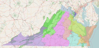
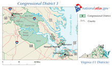
.png) Virginia's 3rd congressional district - from January 3, 2013 to January 16, 2016. | |
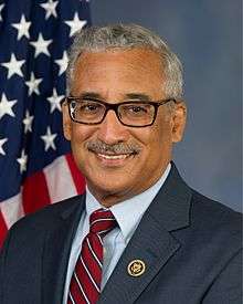
| Current Representative | Robert C. Scott (D–Newport News) |
| Distribution |
|
| Population (2016) | 739,169[2] |
| Median income | $51,794 |
| Ethnicity |
|
| Cook PVI | D+16[3] |
Virginia's third congressional district is a United States congressional district in the Commonwealth of Virginia, serving the independent cities of Franklin, Newport News, and Portsmouth, parts of the independent cities of Chesapeake, Hampton, Norfolk, and Suffolk, and all of the county of Isle of Wight. The current representative is Robert C. Scott (D).
2016 redistricting
The Virginia Legislature's 2012 redistricting was found unconstitutional and replaced with a court-ordered redistricting on January 16, 2016 for the 2016 elections.[4][5][6][7][8] One reason for the redistricting is the racial gerrymandering.[9][10] From 1993 to 2016, the 3rd had covered most of the majority-black precincts in and around Hampton Roads and Richmond. The court-drawn map shifted the area near Richmond to the 4th District. The dispute over the district borders went to the U.S. Supreme Court in Wittman v. Personhuballah.
Recent election results from statewide races
| Year | Office | Results |
|---|---|---|
| 1996 | President | Clinton 72–22% |
| Senator | Warner 72–28% | |
| 1997 | Governor | Beyer 67–31% |
| Lieutenant Governor | Payne 66–28% | |
| Attorney General | Dolan 64–36% | |
| 2000 | President | Gore 66–32% |
| Senator | Robb 67–33% | |
| 2001 | Governor | Warner 71–28% |
| Lieutenant Governor | Kaine 73–26% | |
| Attorney General | McEachin 63–37% | |
| 2004 | President | Kerry 66–33% |
| 2008 | President | Obama 76–24% |
| 2008 | President | Obama 76 24% |
| 2016 | President | Clinton 63–32%[11] |
| 2017 | Governor | Northam 68-31%[12] |
Historical composition of the district
In 1788 Virginia's 3rd Congressional District consisted of all of modern Virginia including and west of the counties of Carroll, Floyd, Roanoke, Botetourt, Augusta and Rockingham. It also included what is today Pendleton County, West Virginia and also about the southern third of West Virginia which in 1788 was all Greenbrier County. This area that is today about 48 counties and 13 independent cities was in 1788 only nine counties.[13]
In the 1790 census this area had a population of 66,045.[14]
For the 1792 congressional elections the number of congressional districts in Virginia rose from 10 to 19. The only county that remained in the third district was Pendleton County. Harrison, Randolph, Hardy, Hampshire, Monongalia and Ohio Counties, all now in West Virginia were also in the district.[15] This was all of northern West Virginia except the far eastern panhandle area. The new district's 1790 population was 30,145.[16]
The 1800 Census lead to another increase in Virginia's congressional districts in 1802. The third district was again moved, this time to what was then Frederick and Shenandoah Counties in Virginia, which besides those counties also included the modern counties of Clarke, Warren and part of Page.[17] The new 3rd district had a population of 38,767 in 1800.[18]
For most of the time from the end of the Civil War to 1993, the 3rd District was a relatively compact district centered on Richmond.
The district's current configuration dates to 1993, when the Justice Department ordered Virginia to create a majority-minority district. At that time, portions of the old 1st, 2nd, 3rd and 4th districts were combined to create a new 3rd District.
As of 2016, the 3rd district has been ruled unconstitutional. The new map gave the 3rd a slight plurality of blacks.[19][20]
List of representatives
| Representative | Party | Term | Note |
|---|---|---|---|
| District created: March 4, 1789 | |||
 |
Anti-Administration | March 4, 1789 – March 3, 1793 |
Redistricted to Virginia 2nd District |
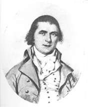
| Joseph Neville | Anti-Administration | March 4, 1793 – March 3, 1795 |
Retired |
| George Jackson | Democratic-Republican | March 4, 1795 – March 3, 1797 |
Lost re-election |
 |
Federalist | March 4, 1797 – March 3, 1799 |
Lost re-election |
| George Jackson | Democratic-Republican | March 4, 1799 – March 3, 1803 |
Retired |
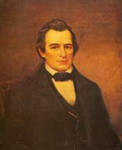
| John Smith | Democratic-Republican | March 4, 1803 – March 3, 1815 |
Retired |
 |
Democratic-Republican | March 4, 1815 – March 3, 1819 |
Elected Virginia State Senator |
| Jared Williams | Democratic-Republican | March 4, 1819 – March 3, 1823 |
Redistricted to Virginia 17th District |
 |
Crawford Republican | March 4, 1823 – March 3, 1825 |
Lost re-election |
| Jacksonian | March 4, 1825 – March 3, 1835 | ||
 |
Jacksonian | March 4, 1835 – March 3, 1837 |
Redistricted to Virginia 6th District |
| Democratic | March 4, 1837 – March 3, 1843 | ||
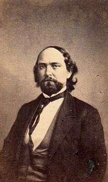
| Walter Coles | Democratic | March 4, 1843 – March 3, 1845 |
Redistricted from Virginia 6th District Retired |
| William M. Tredway | Democratic | March 4, 1845 – March 3, 1847 |
Lost re-election |
| Thomas S. Flournoy | Whig | March 4, 1847 – March 3, 1849 |
Lost re-election |
| Thomas H. Averett | Democratic | March 4, 1849 – March 3, 1853 |
Lost re-election |
 |
Democratic | March 4, 1853 – March 3, 1859 |
Redistricted from Virginia 6th District Lost re-election |
 |
Independent Democrat | March 4, 1859 – March 3, 1861 |
Resigned |
| Vacant | March 4, 1861 – January 27, 1870 |
Civil War | |
 |
Republican | January 27, 1870 – March 3, 1873 |
Retired |
 |
Republican | March 4, 1873 – March 3, 1875 |
Lost re-election |
 |
Democratic | March 4, 1875 – March 3, 1879 |
Retired |
 |
Democratic | March 4, 1879 – March 3, 1881 |
Retired |
 |
Democratic | March 4, 1881 – April 11, 1890 |
Election invalidated |
| Edmund Waddill, Jr. | Republican | April 12, 1890 – March 3, 1891 |
Retired |
|
Democratic | March 4, 1891 – March 3, 1895 |
Retired |
 |
Democratic | March 4, 1895 – March 3, 1897 |
Lost re-election |
 |
Democratic | March 4, 1897 – March 3, 1913 |
Lost re-election |
 |
Democratic | March 4, 1913 – March 3, 1933 |
Redistricted to Virginia At-Large District |
| District eliminated March 4, 1933 | |||
| District recreated: January 3, 1935 | |||
|
Democratic | January 3, 1935 – January 24, 1937 |
Died |
| Vacant | January 24, 1937 – November 2, 1937 | ||
 |
Democratic | November 2, 1937 – February 15, 1945 |
Resigned |
| Vacant | February 15, 1945 – March 6, 1945 | ||
 |
Democratic | March 6, 1945 – January 3, 1965 |
Retired |
 |
Democratic | January 3, 1965 – January 3, 1981 |
Retired |
 |
Republican | January 3, 1981 – January 3, 1993 |
Redistricted to Virginia 7th District |
 |
Democratic | January 3, 1993 – Present |
First elected in 1992 |
Election results
| Year | Democratic | Republican | Independents |
|---|---|---|---|
| 1970 | David E. Satterfield, III: 73,104 | J. Harvie Wilkinson, III: 35,229 | Mrs. Ulrich Troubetskoy: 371 |
| 1972 | David E. Satterfield, III: 102,523 | ||
| 1974 | David E. Satterfield, III: 64,627 | Alan Robert Ogden: 7,574 | |
| 1976 | David E. Satterfield, III: 129,066 | Alan Robert Ogden: 17,503 | |
| 1978 | David E. Satterfield, III: 104,550 | Alan Robert Ogden: 14,453 | |
| 1980 | John A. Mapp: 60,962 | Thomas J. Bliley, Jr.: 96,524 | Howard H. Carwile: 19,549 |
| 1982 | John A. Waldrop, Jr.: 63,946 | Thomas J. Bliley, Jr.: 92,928 | |
| 1984 | Thomas J. Bliley, Jr.: 169,987 | Roger L. Coffey: 28,556 | |
| 1986 | Kenneth E. Powell: 32,961 | Thomas J. Bliley, Jr.: 74,525 | J. Stephen Bodges: 3,675 |
| 1988 | Thomas J. Bliley, Jr.: 187,354 | ||
| 1990 | James A. Starke, Jr.: 36,253 | Thomas J. Bliley, Jr.: 77,125 | Rose L. Simpson: 4,317 |
| 1992 | Robert C. Scott: 132,432 | Daniel Jenkins: 35,780 | |
| 1994 | Robert C. Scott: 108,532 | Thomas E. Ward: 28,080 | |
| 1996 | Robert C. Scott: 118,603 | Elsie Goodwyn Holland: 25,781 | |
| 1998 | Robert C. Scott: 48,129 | R. S. Barnett: 14,453 | |
| 2000 | Robert C. Scott: 137,527 | ||
| 2002 | Robert C. Scott: 87,521 | ||
| 2004 | Robert C. Scott: 159,373 | Winsome E. Sears: 70,194 | |
| 2006 | Robert C. Scott: 133,546 | ||
| 2008 | Robert C. Scott: 239,911 | ||
| 2010 | Robert C. Scott: 114,754 | C. L. Smith, Jr.: 44,553 | John D. Kelly: 1,927 |
| 2012 | Robert C. Scott: 259,199 | Dean J. Longo: 58,931 | |
| 2014 | Robert C. Scott: 139,197 | ||
| 2016 | Robert C. Scott: 208,337 | Martin L. Williams: 103,289 |
Historical district boundaries
See also
Sources
- ↑ Geography, US Census Bureau. "Congressional Districts Relationship Files (state-based)". www.census.gov. Retrieved 9 April 2018.
- ↑ Bureau, Center for New Media & Promotion (CNMP), US Census. "My Congressional District". www.census.gov. Retrieved 9 April 2018.
- ↑ "Partisan Voting Index – Districts of the 115th Congress" (PDF). The Cook Political Report. April 7, 2017. Retrieved April 7, 2017.
- ↑ "Court Ordered Redistricting". Redistricting.dls.virginia.gov. 2015-09-03. Retrieved 2017-05-06.
- ↑ http://redistricting.dls.virginia.gov/2010/Data/Court%20Ordered%20Redistricting/2016%2001%2007%20Personnhuballah%20v%20Alcorn%20Civil%20Action%20No.%203-13cv678.pdf
- ↑ "Supreme Court weighs legality of Virginia redistricting". The Hill. Retrieved 2017-05-06.
- ↑ Lydia Wheeler (2016-02-01). "Supreme Court Allows Virginia Redistricting to Stand in 2016". Rollcall.com. Retrieved 2017-05-06.
- ↑ Andrew Cain (2016-01-07). "Judges impose new Va. congressional map, redrawing 3rd, 4th Districts | Virginia Politics". Richmond Times-Dispatch. Retrieved 2017-05-06.
- ↑ Weiner, Rachel (2014-10-07). "Court declares Virginia's congressional map unconstitutional". The Washington Post. Retrieved 2017-05-06.
- ↑ Farnsworth, Stephen J. (2015-11-05). "The 2015 election in Virginia: A tribute to gerrymandering". The Washington Post. Retrieved 2017-05-06.
- ↑ "2016 November General President". Retrieved November 26, 2016.
- ↑ "2017 Governor's Election Results by Congressional District". The Virginia Public Access Project. Retrieved 2018-06-16.
- ↑ Parsons, Stanley B, William W. Beach and Dan Hermann. United States Congressional Districts 1788-1841. (Westport: Greenwood Press, 1978) p. 29
- ↑ Parsons. Congressional Districts. p. 28
- ↑ Parsons. Congressional Districts. p. 71
- ↑ Parsons. Congressional Districts. p. 70
- ↑ Parsons. Congressional Districts. p. 129
- ↑ Parsons. Congressional Districts. p. 128
- ↑ "Virginia Politics: Court orders redistricting". Daily Press. Retrieved 2017-05-06.
- ↑ By $${element.Contributor} (2016-01-07). "Judges Select New Virginia Congressional Map". Rollcall.com. Retrieved 2017-05-06.
- Martis, Kenneth C. (1989). The Historical Atlas of Political Parties in the United States Congress. New York: Macmillan Publishing Company.
- Martis, Kenneth C. (1982). The Historical Atlas of United States Congressional Districts. New York: Macmillan Publishing Company.
- Congressional Biographical Directory of the United States 1774–present
Coordinates: 37°12′49″N 76°57′04″W / 37.21361°N 76.95111°W