Vincentpiramid
| Vincentpiramid | |
|---|---|
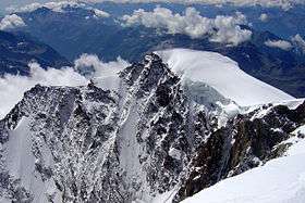 View from the Parrotspitze (north side) | |
| Highest point | |
| Elevation | 4,215 m (13,829 ft) |
| Prominence | 128 m (420 ft) [1] |
| Isolation | 0.7 kilometres (0.43 mi) |
| Parent peak | Dufourspitze |
| Coordinates | 45°54′28″N 7°51′43″E / 45.90778°N 7.86194°ECoordinates: 45°54′28″N 7°51′43″E / 45.90778°N 7.86194°E |
| Geography | |
 Vincentpiramid Location in the Alps | |
| Country | Italy |
| Region | Aosta Valley and Piedmont |
| Parent range | Pennine Alps |
| Climbing | |
| First ascent | 15 August 1819 by the brothers Nicolas and Joseph Vincent from Gressoney-Saint-Jean |
The Vincentpiramid (Walser German, French: Pyramide Vincent, Italian: Piramide Vincent) (4,215 m (13,829 ft)) is a mountain of the Pennine Alps, located on the border between the Italian regions of Aosta Valley and Piedmont. The Vincentpiramid is one of the secondary summits of Monte Rosa. It lies south of the Ludwigshöhe, between the Lysgletscher and the Piode Glacier.
The Vincentpiramid summit was successfully climbed on 15 August 1819 by the brothers Nicolas (Johann Nikolaus) and Joseph Vincent from Gressoney-Saint-Jean, after whom the peak has been named.
It is one of the few peaks on Monte Rosa to lie entirely within Italian territory and is the fourth highest peak, completely in Italy. It is normally ascended from the Gnifetti Hut at the foot of the Lys Glacier and is rated as PD (Peu Difficile); a straightforward introduction to alpine climbing and often ascended in conjunction with another peak on Monte Rosa.[2]
References
- ↑ Retrieved from the Swisstopo topographic maps. The key col is located north of the summit at 4,087 metres.
- ↑ "Monte Rosa: A Love Affair". The Armchair Mountaineer. Retrieved 3 June 2017.
External links
| Wikimedia Commons has media related to Piramide Vincent. |