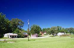
Vina, Alabama
| Vina, Alabama | |
|---|---|
| Town | |
 Vina | |
| Motto(s): "The Best Small Town in Alabama" | |
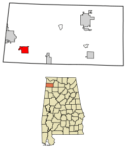 Location of Vina in Franklin County, Alabama. | |
| Coordinates: 34°22′30″N 88°3′13″W / 34.37500°N 88.05361°W | |
| Country | United States |
| State | Alabama |
| County | Franklin |
| Area[1] | |
| • Total | 4.80 sq mi (12.45 km2) |
| • Land | 4.80 sq mi (12.43 km2) |
| • Water | 0.00 sq mi (0.01 km2) |
| Elevation | 682 ft (208 m) |
| Population (2010) | |
| • Total | 358 |
| • Estimate (2017)[2] | 358 |
| • Density | 74.57/sq mi (28.79/km2) |
| Time zone | UTC-6 (Central (CST)) |
| • Summer (DST) | UTC-5 (CDT) |
| ZIP code | 35593 |
| Area code(s) | 256 |
| FIPS code | 01-78984 |
| GNIS feature ID | 0153851 |
| Website |
vinaalabama |
Vina is a town in Franklin County, Alabama, United States. At the 2010 census the population was 358,[3] down from 400 in 2000.
Carl Elliott, the representative of Alabama's 7th congressional district from 1949 to 1965, graduated in 1929 from Vina High School.
Vina was incorporated in 1909.[4]
History
Vina was originally known as "Jones Crossroads," and later as "New Burleson." When a branch of the Illinois Central Railroad was constructed through the area in the early 1900s, the community was renamed "Vina" after the wife of a railroad engineer.[4]
Geography
Vina is located in southwestern Franklin County County at 34°22′30″N 88°3′13″W / 34.37500°N 88.05361°W (34.374874, -88.053498).[5] Alabama State Route 19 passes through the town, leading northwest 7 miles (11 km) to Red Bay and south 21 miles (34 km) to Hamilton.
According to the U.S. Census Bureau, the town has a total area of 4.8 square miles (12.4 km2), all land.[3] The town sits on the Tennessee Valley Divide, with the north side draining via several creeks to Bear Creek, a north-flowing tributary of the Tennessee River; the south side of town drains to Hurricane Creek, a southwest-flowing part of the Tombigbee River watershed.
Demographics
| Historical population | |||
|---|---|---|---|
| Census | Pop. | %± | |
| 1920 | 339 | — | |
| 1930 | 448 | 32.2% | |
| 1940 | 472 | 5.4% | |
| 1950 | 313 | −33.7% | |
| 1960 | 184 | −41.2% | |
| 1970 | 366 | 98.9% | |
| 1980 | 346 | −5.5% | |
| 1990 | 356 | 2.9% | |
| 2000 | 400 | 12.4% | |
| 2010 | 358 | −10.5% | |
| Est. 2017 | 358 | [2] | 0.0% |
| U.S. Decennial Census[6] 2013 Estimate[7] | |||
As of the census[8] of 2000, there were 400 people, 155 households, and 110 families residing in the town. The population density was 100.2 people per square mile (38.7/km²). There were 188 housing units at an average density of 47.1 per square mile (18.2/km²). The racial makeup of the town was 97.50% White, 0.50% Black or African American, 0.25% from other races, and 1.75% from two or more races. 1.75% of the population were Hispanic or Latino of any race.
There were 155 households out of which 31.0% had children under the age of 18 living with them, 41.9% were married couples living together, 21.3% had a female householder with no husband present, and 29.0% were non-families. 26.5% of all households were made up of individuals and 13.5% had someone living alone who was 65 years of age or older. The average household size was 2.58 and the average family size was 3.11.
In the town, the population was spread out with 31.8% under the age of 18, 5.3% from 18 to 24, 27.3% from 25 to 44, 22.3% from 45 to 64, and 13.5% who were 65 years of age or older. The median age was 34 years. For every 100 females, there were 99.0 males. For every 100 females age 18 and over, there were 90.9 males.
The median income for a household in the town was $18,594, and the median income for a family was $20,625. Males had a median income of $23,000 versus $19,444 for females. The per capita income for the town was $10,662. About 46.1% of families and 47.5% of the population were below the poverty line, including 69.3% of those under age 18 and 52.9% of those age 65 or over.
References
- ↑ "2017 U.S. Gazetteer Files". United States Census Bureau. Retrieved Jul 7, 2018.
- 1 2 "Population and Housing Unit Estimates". Retrieved March 24, 2018.
- 1 2 "Geographic Identifiers: 2010 Census Summary File 1 (G001): Vina town, Alabama". American Factfinder. U.S. Census Bureau. Retrieved April 13, 2016.
- 1 2 Sarah Carlson, "Markers Highlight Local Culture," Florence TimesDaily, 10 June 2010.
- ↑ "US Gazetteer files: 2010, 2000, and 1990". United States Census Bureau. 2011-02-12. Retrieved 2011-04-23.
- ↑ "U.S. Decennial Census". Census.gov. Retrieved June 6, 2013.
- ↑ "Annual Estimates of the Resident Population: April 1, 2010 to July 1, 2013". Retrieved June 3, 2014.
- ↑ "American FactFinder". United States Census Bureau. Retrieved 2008-01-31.
External links

- Town of Vina official website
Coordinates: 34°22′30″N 88°03′13″W / 34.374874°N 88.053498°W
Municipalities and communities of Franklin County, Alabama, United States | ||
|---|---|---|
| Cities | 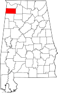 | |
| Towns | ||
| CDPs | ||
| Unincorporated communities | ||