Liberty Hill, Franklin County, Alabama
| Liberty Hill, Alabama | |
|---|---|
| Unincorporated community | |
 Liberty Hill  Liberty Hill | |
| Coordinates: 34°20′51″N 87°45′54″W / 34.34750°N 87.76500°WCoordinates: 34°20′51″N 87°45′54″W / 34.34750°N 87.76500°W | |
| Country | United States |
| State | Alabama |
| County | Franklin |
| Elevation | 981 ft (299 m) |
| Time zone | UTC-6 (Central (CST)) |
| • Summer (DST) | UTC-5 (CDT) |
| Area code(s) | 205 |
| GNIS feature ID | 121568[1] |
Liberty Hill is an unincorporated community in Franklin County, Alabama, United States. Liberty Hill is located on U.S. Route 43 and Alabama State Route 17, 3.4 miles (5.5 km) west of Phil Campbell.[2]
References
- ↑ "Liberty Hill". Geographic Names Information System. United States Geological Survey.
- ↑ Franklin County, Alabama General Highway Map (PDF) (Map). Alabama Department of Transportation. 2005. Retrieved March 13, 2012.
Municipalities and communities of Franklin County, Alabama, United States | ||
|---|---|---|
| Cities | 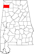 | |
| Towns | ||
| CDPs | ||
| Unincorporated communities | ||
This article is issued from
Wikipedia.
The text is licensed under Creative Commons - Attribution - Sharealike.
Additional terms may apply for the media files.