Van Reenen
| Van Reenen | |
|---|---|
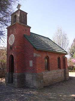 Llandaff Oratory in Van Reenen | |
 Van Reenen  Van Reenen Van Reenen (South Africa)  Van Reenen Van Reenen (Africa) | |
| Coordinates: 28°22′34″S 29°22′52″E / 28.376°S 29.381°ECoordinates: 28°22′34″S 29°22′52″E / 28.376°S 29.381°E | |
| Country | South Africa |
| Province | KwaZulu-Natal |
| District | Uthukela |
| Municipality | Alfred Duma |
| Area[1] | |
| • Total | 0.48 km2 (0.19 sq mi) |
| Elevation | 1,680 m (5,510 ft) |
| Population (2001)[1] | |
| • Total | 78 |
| • Density | 160/km2 (420/sq mi) |
| Racial makeup (2001)[1] | |
| • Black African | 73.1% |
| • Indian/Asian | 11.5% |
| • White | 15.4% |
| First languages (2001)[1] | |
| • Zulu | 46.2% |
| • Sotho | 26.9% |
| • English | 23.1% |
| • Afrikaans | 3.8% |
| Time zone | UTC+2 (SAST) |
| PO box | 3372 |
| Area code | 058 |
Van Reenen is a settlement in Uthukela District Municipality in the KwaZulu-Natal province of South Africa. It is located on the N3 national road at the top of Van Reenen's Pass on the Great Escarpment of the Drakensberg. The town is named after Frans van Reenen, original owner of the farm where Van Reenen was established and planner of the route of the Van Reenen's Pass.[2]
Llandaff Oratory, an eight-seat memorial church built around 1925, is a Heritage Landmark.
Gallery
 Van Reenen's Pass
References
- 1 2 3 4 "Main Place Van Reenen". Census 2001.
- ↑ Raper, R.E. Dictionary of Southern African Place Names. Human Sciences Research Council (South Africa).
Municipalities and communities of UThukela District Municipality, KwaZulu-Natal | ||
|---|---|---|
District seat: Ladysmith | ||
| Alfred Duma | .svg.png) | |
| Inkosi Langalibalele | ||
| Okhahlamba | ||
This article is issued from
Wikipedia.
The text is licensed under Creative Commons - Attribution - Sharealike.
Additional terms may apply for the media files.