Valley Wells, California
| Valley Wells | |
|---|---|
| census-designated place | |
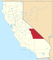
 Valley Wells Location in California  Valley Wells Valley Wells (the US) | |
| Coordinates: 35°49′42″N 117°19′54″W / 35.82833°N 117.33167°WCoordinates: 35°49′42″N 117°19′54″W / 35.82833°N 117.33167°W | |
| Country |
|
| State |
|
| County | Inyo County |
| Area[1] | |
| • Total | 10.737 sq mi (27.809 km2) |
| • Land | 10.669 sq mi (27.632 km2) |
| • Water | 0.068 sq mi (0.177 km2) 0.64% |
| Elevation[2] | 1,749 ft (533 m) |
| Population (2010) | |
| • Total | 0 |
| • Density | 0.0/sq mi (0.0/km2) |
| Time zone | UTC-8 (Pacific (PST)) |
| • Summer (DST) | UTC-7 (PDT) |
| GNIS feature IDs | 1661620; 2408400 |
|
U.S. Geological Survey Geographic Names Information System: Valley Wells, California; U.S. Geological Survey Geographic Names Information System: Valley Wells, California | |
| Reference no. | 443 |
Valley Wells is a census-designated place[3] in Inyo County, California.[2] It lies at an elevation of 1,749 ft (533 m).[2] Prior to 2010, for census purposes it was part of Homewood Canyon-Valley Wells CDP. The 2010 census reported that population was zero.[4] The town is now registered as California Historical Landmark #443; in 1849, several groups of midwestern emigrants settled here to secure water from nearby Searles Lake.[5]
References
- ↑ "2010 Census Gazetteer Files - Places - California". United States Census Bureau. Retrieved March 26, 2015.
- 1 2 3 U.S. Geological Survey Geographic Names Information System: Valley Wells, California
- ↑ U.S. Geological Survey Geographic Names Information System: Valley Wells, California
- ↑ "2010 Census P.L. 94-171 Summary File Data". United States Census Bureau.
- ↑ "Valley Wells". Office of Historic Preservation, California State Parks. Retrieved 2012-10-07.
This article is issued from
Wikipedia.
The text is licensed under Creative Commons - Attribution - Sharealike.
Additional terms may apply for the media files.