Evelyn, California
| Evelyn | |
|---|---|
| Unincorporated community | |
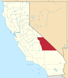
 Evelyn Location in California  Evelyn Evelyn (the US) | |
| Coordinates: 36°08′48″N 116°18′58″W / 36.14667°N 116.31611°WCoordinates: 36°08′48″N 116°18′58″W / 36.14667°N 116.31611°W | |
| Country | United States |
| State | California |
| County | Inyo County |
| Elevation[1] | 1,880 ft (573 m) |
Evelyn is an unincorporated community in Inyo County, California.[1] It is located on the Tonopah and Tidewater Railroad 5 miles (8 km) south-southeast of Eagle Mountain,[2] at an elevation of 1880 feet (573 m).[1]
The place was named in 1907 for Evelyn Kate Smith (née Ellis), wife of Francis Marion Smith of the Pacific Coast Borax Company.[2]
Currently, there are no residents of Evelyn. No structures remain. All that remains is a paved loop of road next to the old railroad grade. The California Department of Transportation uses this area to store paving materials and test equipment for work on California State Route 127 and other area roads.
References
This article is issued from
Wikipedia.
The text is licensed under Creative Commons - Attribution - Sharealike.
Additional terms may apply for the media files.