Vallée de l'Ernz
| Vallée de l'Ernz Ärenzdall | |
|---|---|
| Commune | |
 Ermsdorf | |
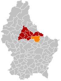 Map of Luxembourg with Vallée de l'Ernz highlighted in orange, and the canton in dark red | |
| Coordinates: 49°49′N 6°13′E / 49.82°N 6.22°ECoordinates: 49°49′N 6°13′E / 49.82°N 6.22°E | |
| Country |
|
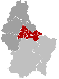
| Canton | Diekirch |
| Government | |
| • Mayor | André Kirschten |
| Area | |
| • Total | 39.73 km2 (15.34 sq mi) |
| Area rank | 12th of 102 |
| Highest elevation | 420 m (1,380 ft) |
| • Rank | 36th of 102 |
| Lowest elevation | 213 m (699 ft) |
| • Rank | 32nd of 102 |
| Population (2014) | |
| • Total | 2,462 |
| • Rank | 53rd of 102 |
| • Density | 62/km2 (160/sq mi) |
| • Density rank | 82nd of 102 |
| Time zone | UTC+1 (CET) |
| • Summer (DST) | UTC+2 (CEST) |
| LAU 2 | LU00002010 |
| Website |
www |
Vallée de l'Ernz (Luxembourgish: Ärenzdall) is a commune in northern Luxembourg, in the canton of Diekirch. The commune of Vallée de l'Ernz was formed on 1 January 2012 from the former communes of Ermsdorf and Medernach. The law creating the Vallée de l'Ernz was passed on 24 May 2011.[1] It has an area of 39.73 km2.
References
- ↑ "Mémorial A, 2011, No. 110" (PDF) (in French). Service central de législation. Retrieved 2012-01-02.
External links

Places adjacent to Vallée de l'Ernz | ||||||||||
|---|---|---|---|---|---|---|---|---|---|---|
| ||||||||||
 | ||
This article is issued from
Wikipedia.
The text is licensed under Creative Commons - Attribution - Sharealike.
Additional terms may apply for the media files.