Erpeldange
| Erpeldange Ierpeldeng | ||
|---|---|---|
| Commune | ||
 | ||
| ||
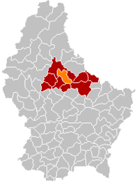 Map of Luxembourg with Erpeldange highlighted in orange, and the canton in dark red | ||
| Coordinates: 49°51′N 6°06′E / 49.85°N 6.1°ECoordinates: 49°51′N 6°06′E / 49.85°N 6.1°E | ||
| Country |
| |
| Canton | Diekirch | |
| Government | ||
| • Mayor | Claude Gleis | |
| Area | ||
| • Total | 17.97 km2 (6.94 sq mi) | |
| Area rank | 65 of 102 | |
| Highest elevation | 459 m (1,506 ft) | |
| • Rank | 24th of 102 | |
| Lowest elevation | 190 m (620 ft) | |
| • Rank | 22nd of 102 | |
| Population (2014) | ||
| • Total | 2,347 | |
| • Rank | 58th of 102 | |
| • Density | 130/km2 (340/sq mi) | |
| • Density rank | 53rd of 102 | |
| Time zone | UTC+1 (CET) | |
| • Summer (DST) | UTC+2 (CEST) | |
| LAU 2 | LU00002006 | |
| Website | erpeldange.lu | |

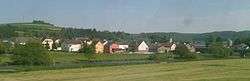
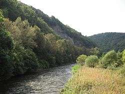
Erpeldange (Luxembourgish: Ierpeldeng, German: Erpeldingen) is a commune and small town in north-eastern Luxembourg. It lies along the river Sauer, between Ettelbruck and Diekirch. It is part of the canton of Diekirch, which is part of the district of Diekirch.
As of 2001, the town of Erpeldange, which lies in the centre of the commune, has a population of 818. Other towns within the commune include Burden and Ingeldorf
Erpeldange was formed on 1 July 1850, when it was detached from the commune of Ettelbruck, along with the commune of Schieren. The law forming Erpeldange was passed on the 22 January 1850.[1]
Erpeldange Castle now houses the commune's administrative offices. It has a history dating from the 13th century.[2]
References
- ↑ (in French)/(in German) "Mémorial A, 1850, No. 18" (PDF). Service central de législation. Retrieved 2006-08-15.
- ↑ "Histoire" Archived 2009-12-01 at the Wayback Machine., Commune d'Erpeldange. (in French) Retrieved 26 March 2011.
External links
![]()
- Official Website for Erpeldange
- Official website of the Erpeldange tourist board
- Football club in Erpeldange
- Team III from the Football club in Erpeldange
- Erpeldange Youth association
- Band and Choir Concordia Erpeldange
Places adjacent to Erpeldange | ||||||||||
|---|---|---|---|---|---|---|---|---|---|---|
| ||||||||||