Vajont Dam
| Vajont Dam | |
|---|---|
 | |
| Official name | Vajont Dam |
| Location | Italy |
| Coordinates | 46°16′02″N 12°19′44″E / 46.26722°N 12.32889°ECoordinates: 46°16′02″N 12°19′44″E / 46.26722°N 12.32889°E |
| Construction began | 1956 |
| Operator(s) | SADE – Società Adriatica di Elettricità |
| Dam and spillways | |
| Height | 262 metres (860 ft) |
| Length | 160 metres (520 ft) (chord) |
| Width (base) | 27 metres (89 ft) (89 ft) |
| Reservoir | |
| Creates | Lago del Vajont |
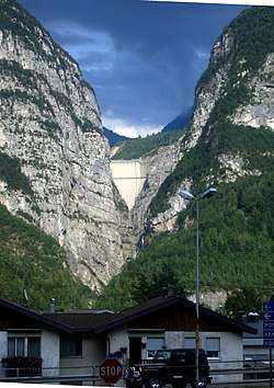
The Vajont Dam (or Vaiont Dam)[2] is a disused dam, completed in 1959 in the valley of the Vajont River under Monte Toc, in the municipality of Erto e Casso, 100 km (60 miles) north of Venice, Italy. One of the tallest dams in the world, it is 262 metres (860 ft) high, 27 metres (89 ft) wide and 22.11 metres (72 ft 6 in) thick at the base and 191 metres (627 ft) wide and 3.4 metres (11 ft 2 in) thick at the top.[3]
On 9 October 1963, during initial filling, a massive landslide caused a man-made megatsunami in the lake in which 50 million cubic metres of water overtopped the dam in a wave 250 metres (820 ft) high, leading to 1,910 deaths and the complete destruction of several villages and towns.
The construction company and the Italian government initially disregarded early warning signs and reports describing the geological instability of Monte Toc on the southern side of the basin. The eventual attempt to safely control the landslide by lowering the lake level was too late. The dam remained almost intact and two thirds of the water was retained behind it, but the landslide was much larger than expected and the impact brought massive flooding and destruction to the Piave valley below.
Construction
The 'tallest dam in the world', was conceived in the 1920s, to control and harness the rivers Piave, Maè and the Boite stream, and to meet the growing demand for power generation and industrialization. It was designed by Carlo Semenza, and eventually built between 1957 and 1960 by Società Adriatica di Elettricità ("SADE", or "EDIS") (English: Adriatic Energy Corporation), the electricity supply and distribution monopoly in northeastern Italy, which was owned by Giuseppe Volpi di Misurata. In 1962 the dam was nationalized and came under the control of ENEL as part of the Italian Ministry for Public Works. It was described as 'the tallest dam in the world', intended to meet the growing demands of industrialization, and as of 2018 is still one of the tallest in the world.
The dam had a volume of 360,000 m³ and held up to 168,715,000 cubic metres of water. The dam and basin were intended to be at the centre of a complex system of water management in which water would have been channeled from nearby valleys and artificial basins located at higher levels. Tens of kilometres of concrete pipes and pipe-bridges across valleys were planned.
In the 1950s, SADE's monopoly was confirmed by post-fascist governments and it bought the land despite opposition by the communities of Erto and Casso in the valley, which was overcome with government and police support. SADE stated that the geology of the gorge had been studied, including analysis of ancient landslides, and that the mountain was believed to be sufficiently stable.
Construction work started in 1957, but by 1959 shifts and fractures were noticed during the construction of a new road on the side of Monte Toc. This led to new studies in which three experts separately told SADE that the entire side of Monte Toc was unstable and would likely collapse into the basin if the filling were completed.[4] All three were ignored by SADE. Construction was completed in October 1959, and in February 1960, SADE was authorised to start filling the basin. In 1962 the dam was nationalized and came under the control of ENEL as part of the Italian Ministry for Public Works.
Early signs of disaster
On March 22, 1959, during construction of the Vajont Dam, a landslide at the nearby Pontesei dam created a 20 meters (66 ft) high wave that killed one person.[5]
Throughout the summer of 1960, minor landslides and earth movements were noticed. However, instead of heeding these warning signs, the Italian government chose to sue at least one of the journalists reporting the problems.[6]
On 4 November 1960, with the water level in the reservoir at about 190 metres (620 ft) of the planned 262 metres (860 ft), a landslide of about 800,000 cubic metres (1,000,000 cu yd) collapsed into the lake. SADE stopped the filling, lowered the water level by about 50 metres (160 ft), and started to build an artificial gallery in the basin in front of Monte Toc to keep the basin usable even if additional landslides (which were expected) divided it into two parts.[7]
In October 1961, after the completion of the gallery, SADE resumed filling the narrow reservoir under controlled monitoring. In April and May 1962, with the basin water level at 215 metres (705 ft), the people of Erto and Casso reported five "grade five" Mercalli intensity scale earthquakes. SADE downplayed the importance of these quakes.[8] SADE was then authorized to fill the reservoir to the maximum level.
In July 1962, SADE's own engineers reported the results of model-based experiments on the effects of further landslides from Monte Toc into the lake. The tests indicated that a wave generated by a landslide could top the crest of the dam if the water level was 20 metres (66 ft) or less from the dam crest. It was therefore decided that a level 25 metres (82 ft) below the crest would prevent any displacement wave from over-topping the dam. However, a decision was made to fill the basin beyond that, because the engineers thought they could control the rate of the landslide by controlling the level of water in the reservoir.
In March 1963, the dam was transferred to the newly constituted government service for electricity, ENEL. During the following summer, with the basin almost completely filled, slides, shakes, and movements of the ground were continuously reported by the alarmed population. On 15 September, the entire side of the mountain slid down by 22 centimetres (8.7 in). On 26 September, ENEL decided to slowly empty the basin to 240 metres (790 ft), but in early October the collapse of the mountain's south side looked unavoidable: one day it moved almost 1 metre (3.3 ft).
Landslide and wave

On 9 October 1963, engineers saw trees falling and rocks rolling down into the lake where the predicted landslide would take place. Before this, the alarming rate of movement of the landslide had not slowed as a result of lowering the water, although the water had been lowered to what SADE believed was a safe level to contain the displacement wave should a catastrophic landslide occur.
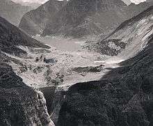
At 10:39 p.m., a massive landslide of about 260,000,000 cubic metres (340,000,000 cu yd) of forest, earth, and rock fell into the reservoir at up to 110 kilometres per hour (68 mph), completely filling the narrow reservoir behind the dam. The landslide was complete in just 45 seconds, much faster than predicted, and the resulting displacement of water caused 50,000,000 cubic metres (65,000,000 cu yd) of water to overtop the dam in a 250-metre (820 ft) high wave.[1]
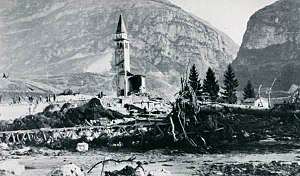
The flooding from the huge wave in the Piave valley destroyed the villages of Longarone, Pirago, Rivalta, Villanova and Faè, killing around 2,000 people and turning the land below the dam into a flat plain of mud[9] with an impact crater 60 metres (200 ft) deep and 80 metres (260 ft) wide. Many small villages near the landslide along the lakefront also suffered damage from a giant displacement wave. Villages in the territory of Erto e Casso and the village of Codissago, near Castellavazzo, were largely wrecked.[10]
Estimates of the dead range from 1,900 to 2,500 people, and about 350 families lost all members. Most of the survivors had lost relatives and friends along with their homes and belongings. US Army helicopters and paratroopers aided in rescue efforts and bringing in relief supplies. In 300 flights they ferried out 4,000 survivors.
The dam was largely undamaged, and still exists today.[11][12]
Causes and responsibility
Immediately after the disaster, the government (which at the time owned the dam), politicians and public authorities insisted on attributing the tragedy to an unexpected and unavoidable natural event.
The debate in the newspapers was heavily influenced by politics. The paper l'Unità, the mouthpiece of the Partito Comunista Italiano (PCI), was the first to denounce the actions of the management and government, as it had previously carried a number of articles by Tina Merlin addressing the behaviour of the SADE management in the Vajont project and elsewhere. Indro Montanelli, then the most influential Italian journalist and a vocal anti-communist, attacked l'Unità and denied any human responsibility; l'Unità and the PCI were dubbed "jackals, speculating on pain and on the dead" in many articles by the Domenica del Corriere and a national campaign poster paid for by Democrazia Cristiana (DC). The catastrophe was attributed only to natural causes and "God's will".[13]
The campaign accused the PCI of sending agitprops into the refugee communities, as relief personnel; most of them were partisans from Emilia Romagna who fought on Mount Toc in the Second World War and often had friends in the stricken area.[14]
Democrazia Cristiana, the party of prime minister Giovanni Leone, accused the Communist Party of 'political profiteering' from the tragedy. Leone promised to bring justice to the people killed in the disaster. A few months after he lost the premiership, he became the head of SADE's team of lawyers, who significantly reduced the amount of compensation for the survivors and ruled out payment for at least 600 victims.[15]
The DC's newspaper, La Discussione,[16] called the disaster "a mysterious act of God's love", in an article that drew sharp criticism from l'Unità.[17]
Apart from journalistic attacks and the attempted cover-up from news sources aligned with the government, there had been proven flaws in the geological assessments, and disregard of warnings about the likelihood of a disaster by SADE, ENEL and the government.
The trial was moved to L'Aquila, in Abruzzo, by the judges who heard the preliminary trial, thus preventing public participation, and resulted in lenient sentencing for a handful of the SADE and ENEL engineers. One SADE engineer (Mario Pancini) committed suicide in 1968. The government never sued SADE for damage compensation.
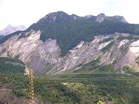
Subsequent engineering analysis has focused on the cause of the landslide, and there is ongoing debate about the contribution of rainfall, dam level changes and earthquakes as triggers of the landslide, as well as differing views about whether it was an old landslide that slipped further or a completely new one.[18]
There were a number of problems with the choice of site for the dam and reservoir: the canyon was steep sided, the river had undercut its banks, and the limestone and clay-stone rocks that made up the walls of the canyon were inter-bedded with the slippery clay-like Lias and Dogger Jurassic-period horizons and the Cretaceous-period Malm horizon, all of which were inclined towards the axis of the canyon. In addition, the limestone layers contained many solution caverns that became only more saturated because of rains in September.[19]
Before the landslide that caused the overtopping flood, the creep of the regolith had been 1.01 centimetres (0.40 in) per week. In September, this creep reached 25.4 centimetres (10.0 in) per day until finally, the day before the landslide, the creep was measured at 1 metre (3.3 ft).[19]
Reconstruction
Most of the survivors were moved into a newly built village, Vajont, 50 km (31 mi) south-east on the Tagliamento river plain. Those who insisted on returning to their mountain life in Erto e Casso were strongly discouraged. Longarone, in the Piave valley, was rebuilt.[20][21]
The government used the disaster to promote the industrialization of the North-East of Italy. Survivors were entitled to 'business start-up' loans, public subsidies and ten years tax exemption, all of which they could 'sell-on' to major companies from the Venice region. These concessions were then converted into millions of lira for plants elsewhere. Among the corporations were Zanussi (now owned by Electrolux), Ceramica Dolomite (now owned by American Standard), Confezioni SanRemo, and SAVIC (now owned by Italcementi).[22]
Compensation measures did not clearly distinguish between victims and people who lived nearby; thus much of the compensation went to people who had suffered little damage, creating a negative public image.
A pumping station was installed in the dam basin to keep the lake at a constant level, and the bypass gallery was lengthened beyond the dam to let the water flow down to the Piave valley. The dam wall is still in place and maintained, but there are no plans to exploit it. The dry basin, filled with landslip, has been open to visitors since 2002.
Current status and memorials
In recent years there has been a revival of interest both by researchers with specialist interest, and sightseers. The dam, now owned by ENEL, was partially opened to the public in 2002 with guided tours and access to the walkway along the top and other locations. In September 2006 an annual non-competitive track event, called "Paths of Remembrance", was inaugurated, which allows participants to access some locations inside the mountain.
On 12 February 2008, while launching the International Year of Planet Earth, UNESCO cited the Vajont Dam tragedy as one of five "cautionary tales", caused by "the failure of engineers and geologists".[23]
For 2013, on the occasion of the fiftieth anniversary of the disaster, the region of Venice set aside one million euro for safety works and recovery of tunnels inside the mountain which were part of the "road Colomber" (the old national road 251).
The memorial church in Longarone—although its construction was strongly opposed by the surviving parish priest—is a late masterpiece of the famous architect Giovanni Michelucci.
In the media
After the initial worldwide reporting,[24] the tragedy became regarded as part of the price of economic growth in the 1950s and 1960s.
Interest was rejuvenated by a 1997 television program by Marco Paolini and Gabriele Vacis, "Il racconto del Vajont".
In 2001, a docudrama about the disaster was released. A joint production of Italian and French companies, it was titled Vajont—La diga del disonore ("Vajont—The Dam of Dishonour") in Italy, and La Folie des hommes ("The Madness of Men") in France. It stars Michel Serrault and Daniel Auteuil.
It was studied in the 2008 documentary series Disasters of the Century.[25]
The TV show Seconds From Disaster featured the event in episode two of the fifth season, "Mountain Tsunami" in 2012.[26][27]
In 2013, the eleventh stage of the Giro d'Italia finished in Vajont to commemorate the fiftieth anniversary of the disaster.[28]
The TV show Make It Out Alive (Smithsonian Channel) featured the disaster in November 2017 in Season 1, Episode 6.
In March 2018, the dam and the disaster were also covered in Season 2, Episode 1 of Science Channel's Mysteries of the Abandoned.
See also
References
- 1 2 The Vajont Dam Disaster Archived 27 February 2008 at the Wayback Machine., TeLL-Net Kick-Off Assembly, 2006, retrieved January 2008.
- ↑ "Vaiont Dam photos and virtual field trip". University of Wisconsin. Archived from the original on 29 July 2009. Retrieved 1 July 2009.
- ↑ "Capolavoro d'ingegneria nel posto sbagliato". Gruppo Editoriale L'Espresso Spa. Retrieved 19 September 2014.
- ↑ T. Merlin, Sulla pelle viva, Cierre Edizioni, Verona, 1993, pp. 59 and 73.
- ↑ See:
- "Release of 50 million m3 of water at the Vajont Dam [on] October 9, 1963 [in] Erto e Casso (PN), Italy," French Ministry for Sustainable Development, November 2010, pp. 1–2. Available at: ARIA
- Lago di Pontesei in Italian Wikipedia (in Italian)
- ↑ https://www.aria.developpement-durable.gouv.fr/wp-content/files_mf/FD_23607_Vajont_Italie_1963_ang.pdf
- ↑ A. De Nardi, Il bacino del Vajont e la frana del M. Toc, 1965, p. 27.
- ↑ T. Merlin, ibidem, p. 102.
- ↑ "Vajont, il muro d'acqua che ha ucciso Longarone". Lastampa.It. 9 October 2008. Archived from the original on 30 September 2012. Retrieved 29 October 2012.
- ↑ Enrico Camanni (2016-06-09). Alpi ribelli: Storie di montagna, resistenza e utopia. Gius.Laterza & Figli Spa. pp. 94–. ISBN 978-88-581-2599-1.
- ↑ John Hall Stephens (1976). The Guinness book of structures: bridges, towers, tunnels, dams. Guinness Superlatives.
- ↑ Éric Gilli; Christian Mangan; Jacques Mudry (14 September 2012). Hydrogeology: Objectives, Methods, Applications. CRC Press. pp. 301–. ISBN 978-1-57808-794-5.
- ↑ "Mattolinimusic.com". Mattolinimusic.com. Retrieved 2012-10-29.
- ↑ "La rabbia e la speranza". Tinamerlin.it. Archived from the original on 17 April 2012. Retrieved 29 October 2012.
- ↑ "Vajont, Due Volte Tragedia". Sopravvissutivajont.org. 2002-10-09. Retrieved 2012-10-29.
- ↑ La Discussione at Italian Wiki (temp ref)
- ↑ L'Unità, 24 October 1963
- ↑ David Petley. "Landslide information: The Vajont (Vaiont) Landslide, 2001". Land-man.net. Archived from the original on 13 August 2006. Retrieved 8 January 2008.
- 1 2 M. Dane Picard, Mountains and Minerals, Rivers and Rocks: A geologist's notes from the field, Pub. Chapman & Hall (1993)
- ↑ Duff, Mark (10 October 2013). "Night of the 'tsunami'" – via www.bbc.com.
- ↑ "2000 people, 11 family members, died in 1963 Italian rockslide".
- ↑ L. Vastano, Vajont, l'onda lunga, Salani Editore, Varese, 2008, pp. 80–3.
- ↑ "Five Cautionary Tales and Five Good News Stories". International Year of Planet Earth – Global Launch Event. Latest Science Web News-lswn.it. 11 February 2008. ISSN 1827-8922. Archived from the original on 8 March 2014. Retrieved 4 January 2009.
- ↑ Towns wiped out in night of horror (Newsreel). MCA/Universal Pictures. 14 October 1963. National Archives Identifier 2050680. Retrieved 7 October 2013.
- ↑ History Television, Vajont Dam Collapse Archived 6 July 2011 at the Wayback Machine., retrieved January 2008.
- ↑ "Seconds from Disaster, Schedule, Video, Photos, Facts and More – National Geographic Channel: Episode Guide – Series 5 – National Geographic Channel".
- ↑ "Mega Disasters – Mountain Tsunami". 7 June 2015.
- ↑ Cycling News, Giro d'Italia 2013 Stage 11
Bibliography
- Franco Mantovania and Claudio Vita-Finzi, 'Neotectonics of the Vajont dam site', Geomorphology, Vol. 54, Issues 1–2, 2003, pp 33–37.
- David Petley, Landslide information: The Vajont (Vaiont) Landslide, 2001, retrieved January 2008.
- Suburban Emergency Management Project (SEMP), 'Epic Vajont Dam Disaster, Italy, 1963: Manmade or Natural?', Biot #373: 17 June 2006, retrieved January 2008.
External links
| Wikimedia Commons has media related to Vajont Dam. |
- Kiersch, G. A. The Vaiont Reservoir Disaster. Mineral Information Service, July 1965, pp. 129–38. (in English)
- Vajont dam disaster: a fascist legacy (in English)
- Vajont forecast manslaughter (in English)
- Sito documentale antimafia Vajont (in Italian)
- Eyewitnesses, 1964's original movie (2.000 condanne) (in Italian)
- the last OUTRAGE: in fact, a mere commercial business. Again... (in Italian)
- ...Testuale: i FESTEGGIAMENTI del CINQUANTESIMO della TRAGEDIA (in Italian)
- Vajont, l'onda lunga, Lucia Vastano. Libro inchiesta, testo di corso IUAV Venezia (in Italian)
- Il disastro del Vajont (in Italian)
- Comitato Sopravissuti del Vajont (in Italian)
- Vajont: Almost a Greek Tragedy (in English)
- Vajont, La diga del disonore on IMDb
- Vajont Dam photos and virtual field trip (University of Wisconsin), retrieved 2009-07-01