Monte Toc
| Monte Toc | |
|---|---|
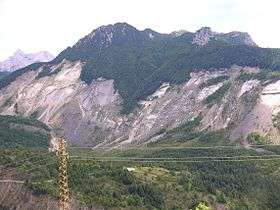 The area of the 1963 landslide on Monte Toc, taken in 2005 | |
| Highest point | |
| Elevation | 1,921 m (6,302 ft) |
| Coordinates | 46°14′N 12°20′E / 46.233°N 12.333°ECoordinates: 46°14′N 12°20′E / 46.233°N 12.333°E |
| Geography | |
 Monte Toc Location in the Alps | |
| Location | Pordenone, Italy |
| Parent range | Venetian Prealps |
Monte Toc, nicknamed the walking mountain by locals due to its tendency to landslide, is a mountain on the border between Veneto and Friuli-Venezia Giulia in Northern Italy best known for the Vajont Dam, which was built at the mountain's base in 1960.
On October 9, 1963, 260 million cubic metres[1] of rock slid down the side of Mount Toc and plunged into the reservoir created by the Vajont Dam sending a wave of water 250 metres high over the dam wall and destroying the town of Longarone and its suburbs.[1][2] 1,918 people were killed, 1,450 of whom were in Longarone.
References
- 1 2 Petley, Dave (Professor) (2008-12-11). "The Vaiont (Vajont) landslide of 1963". The Landslide Blog. Archived from the original on 2013-12-06. Retrieved 2014-02-26.
- ↑ Duff, Mark (2013-10-10). "Italy Vajont anniversary: Night of the 'tsunami'". BBC News. Bbc.co.uk. Retrieved 2014-02-27.
External links
- Excerpt from: Silenced Rivers: The Ecology and Politics of Large Dams by Patrick McCully
This article is issued from
Wikipedia.
The text is licensed under Creative Commons - Attribution - Sharealike.
Additional terms may apply for the media files.