Uturoa
| Uturoa | |
|---|---|
| Commune | |
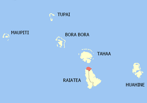 Location of the commune (in red) within the Windward Islands | |
| Coordinates: 16°43′52″S 151°26′35″W / 16.731°S 151.443°WCoordinates: 16°43′52″S 151°26′35″W / 16.731°S 151.443°W | |
| Country | France |
| Overseas collectivity | French Polynesia |
| Government | |
| • Mayor | Sylviane Terooatea |
| Area | 15 km2 (6 sq mi) |
| Population (August 2007 census)1 | 3,778 |
| • Density | 250/km2 (650/sq mi) |
| Time zone | UTC-10 |
| INSEE/Postal code | 98758 /98735 |
| Elevation | 0–479 m (0–1,572 ft) |
| 1 Population without double counting: residents of multiple communes (e.g., students and military personnel) only counted once. | |
Uturoa is a commune (Islands) of French Polynesia and an overseas territory of France in the Pacific Ocean. Uturoa is located on the island of Raiatea in the administrative subdivision of the Leeward Islands, of which Uturoa is the administrative capital.[1] The Leeward Islands are part of the Society Islands, and Uturoa is the main port of Raiatea Island. During August of 2007, the urban area of Uturoa had 8,735 inhabitants, 3,778 of whom lived in Uturoa proper. Uturoa is about 120 mi (200 km) northwest of Papeete, the Tahitian capital. The present mayor of Uturoa is Sylviane Terooatea.
Transport
Raiatea Airport is a single-runway airport located in Eastern Uturoa and linked to many nearby islands. Air Tahiti is one of the main airlines in Uturoa. Its runway is made of asphalt and stretches to the eastern side of the island. Air Tahiti provides service to Faa'a International Airport to make over seas flights. Ferries from Raiatea sail north to Tahaa, to Vaitape/Bora Bora to the north-west, and to Tahiti to the south-east. Most airlines in Tahiti are American, including Delta, United, JetBlue, and Frontier.
History
Early Polynesians, traveling from Southeast Asia, were the first people to settle in Uturoa. The settlers built houses from branches and grass. Fish, bananas, and apples were their main food. The first European to visit Uturoa was Pedro Fernandez de Quirós in 1606, charting it as Fugitive.[2] During the 1700s, Captain James Cook arrived at Tahiti, and many more French Polynesian islands to map most of the Pacific Ocean. Later, Charles Darwin would arrive, exploring Moorea, and the other Society Islands. An 1896 raid by the forces of Queen Mamea in retaliation for the French annexation of her kingdom killed several traders.[3] Don the Beachcomber resided in Uturoa for some of his life. Uturoa experienced major population growth during the 1940s.
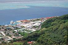
Harbor
Container ships and ferries are found throughout the harbor. The ferries sail to the other Society Islands such as Bora Bora and Moorea. The harbor's size is limited by a short coastline.
Recreation
Uturoa has parks near the harbor, with the closest being the Uturoa Coastal Park. The parks on the mountains close to Uturoa have a view of both the harbor and the city, which makes them beautiful. School parks are found throughout Raiatea and usually have wide open spaces.
Geography
Uturoa is around 169 mi (270 km) from Teahupo'o, a district of Tahiti. Teahupo is close to a reef break that has enormous swells. The northernmost point is Raiatea and has a view of Bora Bora, Taha'a, and Huahine. The commune is about 5 ft (1.5 m) above sea level on average. The mountains of Uturoa are not far inland and sometimes touch the coast and form coastal ranges. Uturoa is situated between the small pass of Taha'a and the forest-covered mountains of Raiatea. This small territory is located between a blue lagoon and t Mount Tapioi, 294 meters high.[4]
Weather
Temperature is usually between 20-30 degrees Celsius throughout the year. The rainy season is considered to be between the months of November - May, with the average rainfall being around 17 days per month. Humidity levels hover around 80% and remain consistent throughout the year.[5]
Beaches
Some beaches of Uturoa have black sand in part due to past volcanic eruptions. The beaches give way to an industrialized coast filled with cranes and container ships.
Nearby communes
Uturoa is part of the Raiatea commune. Two other districts make up Raiatea: Huahine, which is about 31 mi (50 km) away from Raiatea and is home to Fare, a large community; and Tahaa, which is just across the strait. The main island of Bora Bora (Anau) can be seen from Uturoa.
Sports
Major sports include football and basketball. Due to high rates of tourism, water sports are also vastly popular in Uturoa, including sailing, jet skiing, water skiing, kayaking, and windsurfing.
See also
References
- ↑ "Raiatea".
- ↑ Burney, James A chronological history of the discoveries in the South Sea or the Pacific Ocean London, 1803, vII, p.326.
- ↑ "Mamea is Plucky". The Saint Paul Globe (Page 9). April 12, 1896. Retrieved 14 April 2018.
- ↑ Stanley, David (2003-08-26). Moon Handbooks Tahiti: Including the Cook Islands. David Stanley. ISBN 9781566914123.
- ↑ https://weather-and-climate.com/average-monthly-Rainfall-Temperature-Sunshine,uturoa-raiatea-pf,French-Polynesia
External links
| Wikimedia Commons has media related to Uturoa. |