Urupá
| Urupá | |||
|---|---|---|---|
| Municipality | |||
| |||
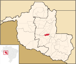 Location in Rondônia state | |||
 Urupá Location in Brazil | |||
| Coordinates: 11°8′26″S 62°21′39″W / 11.14056°S 62.36083°WCoordinates: 11°8′26″S 62°21′39″W / 11.14056°S 62.36083°W | |||
| Country |
| ||
| Region | North Region | ||
| State | Rondônia | ||
| Area | |||
| • Total | 832 km2 (321 sq mi) | ||
| Population (2015) | |||
| • Total | 13,293 | ||
| • Density | 16/km2 (41/sq mi) | ||
| Time zone | BRT-1 (UTC-4) | ||
Urupá is a municipality located in the Brazilian state of Rondônia. Its population was 13,293 (2015) and its area is 832 km2.[1]
References
Capital: Porto Velho | ||
| Alvorada d'Oeste | 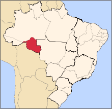 | |
| Ariquemes | ||
| Cacoal | ||
| Colorado do Oeste | ||
| Guajara-Mirim | ||
| Ji-Parana | ||
| Porto Velho | ||
| Vilhena | ||
This article is issued from
Wikipedia.
The text is licensed under Creative Commons - Attribution - Sharealike.
Additional terms may apply for the media files.