Urmitz
| Urmitz | ||
|---|---|---|
| ||
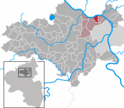
 Urmitz Location of Urmitz within Mayen-Koblenz district  | ||
| Coordinates: 50°24′51″N 7°31′11″E / 50.41417°N 7.51972°ECoordinates: 50°24′51″N 7°31′11″E / 50.41417°N 7.51972°E | ||
| Country | Germany | |
| State | Rhineland-Palatinate | |
| District | Mayen-Koblenz | |
| Municipal assoc. | Weißenthurm | |
| Government | ||
| • Mayor | Manfred Kuhn | |
| Area | ||
| • Total | 3.77 km2 (1.46 sq mi) | |
| Elevation | 66 m (217 ft) | |
| Population (2017-12-31)[1] | ||
| • Total | 3,437 | |
| • Density | 910/km2 (2,400/sq mi) | |
| Time zone | CET/CEST (UTC+1/+2) | |
| Postal codes | 56220 | |
| Dialling codes | 02630 | |
| Vehicle registration | MYK | |
| Website | urmitz.de | |
Urmitz is a municipality in the district of Mayen-Koblenz in Rhineland-Palatinate, western Germany. In 4th millennium BC it contained one of the largest fortified settlements of the time. This archaeological site has since been destroyed by modern constructions.
Local council
The local council has 20 members.
The elections in 2014 showed the following results.[2]
| Election | SPD | CDU | Total |
|---|---|---|---|
| 2014 | 12 | 8 | 20 seats |
| 2009 | 12 | 8 | 20 seats |
| 2004 | 12 | 8 | 20 seats |
References
- ↑ Statistisches Landesamt Rheinland-Pfalz "Bevölkerungsstand 2017 - Gemeindeebene" Check
|url=value (help). Statistisches Landesamt Rheinland-Pfalz (in German). 2018. - ↑ Der Landeswahlleiter Rheinland-Pfalz: Kommunalwahl 2014, Stadt- und Gemeinderatswahlen
This article is issued from
Wikipedia.
The text is licensed under Creative Commons - Attribution - Sharealike.
Additional terms may apply for the media files.
