Unterwellenborn
| Unterwellenborn | ||
|---|---|---|
| ||
 Unterwellenborn Location of Unterwellenborn within Saalfeld-Rudolstadt district 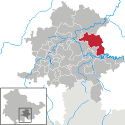 | ||
| Coordinates: 50°39′31″N 11°26′31″E / 50.65861°N 11.44194°ECoordinates: 50°39′31″N 11°26′31″E / 50.65861°N 11.44194°E | ||
| Country | Germany | |
| State | Thuringia | |
| District | Saalfeld-Rudolstadt | |
| Government | ||
| • Mayor | Andrea Wende | |
| Area | ||
| • Total | 63.06 km2 (24.35 sq mi) | |
| Elevation | 265 m (869 ft) | |
| Population (2017-12-31)[1] | ||
| • Total | 8,533 | |
| • Density | 140/km2 (350/sq mi) | |
| Time zone | CET/CEST (UTC+1/+2) | |
| Postal codes | 07333, 07334, 07336, 07387 | |
| Dialling codes | 03647, 03671, 036732 | |
| Vehicle registration | SLF | |
| Website | www.unterwellenborn.de | |

Unterwellenborn is a municipality in the district Saalfeld-Rudolstadt, in Thuringia, Germany. It was created on 1 February 2006 by fusion of the municipalities Birkigt, Goßwitz, Könitz, Lausnitz bei Pößneck and Unterwellenborn itself which had cooperated earlier as Verwaltungsgemeinschaft Unterwellenborn. Already on 9 April 1994, the municipalities Dorfkulm, Langenschade and Oberwellenborn had become part of the municipality of Unterwellenborn. In July 2018 the former municipality of Kamsdorf was merged into Unterwellenborn.
References
This article is issued from
Wikipedia.
The text is licensed under Creative Commons - Attribution - Sharealike.
Additional terms may apply for the media files.