Oberweißbach
| Oberweißbach | ||
|---|---|---|
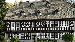 Friedrich Fröbel's birthplace in Oberweißbach | ||
| ||
 Oberweißbach Location of Oberweißbach within Saalfeld-Rudolstadt district  | ||
| Coordinates: 50°34′58″N 11°8′40″E / 50.58278°N 11.14444°ECoordinates: 50°34′58″N 11°8′40″E / 50.58278°N 11.14444°E | ||
| Country | Germany | |
| State | Thuringia | |
| District | Saalfeld-Rudolstadt | |
| Municipal assoc. | Bergbahnregion/Schwarzatal | |
| Government | ||
| • Mayor | Bernhard Schmidt[1] | |
| Area | ||
| • Total | 9.62 km2 (3.71 sq mi) | |
| Elevation | 670 m (2,200 ft) | |
| Population (2017-12-31)[2] | ||
| • Total | 1,678 | |
| • Density | 170/km2 (450/sq mi) | |
| Time zone | CET/CEST (UTC+1/+2) | |
| Postal codes | 98744 | |
| Dialling codes | 036705 | |
| Vehicle registration | SLF | |
| Website | Official website | |

Oberweißbach (or Oberweissbach) is a town in the district of Saalfeld-Rudolstadt, in Thuringia, Germany.

Overview
Oberweißbach is situated in the Thuringian Forest, 17 km (11 mi) southwest of Saalfeld. On 1 December 2008, it incorporated the former municipality Lichtenhain/Bergbahn.
Geography
Oberweißbach is a nationally recognized resort town in the Thuringian Forest Nature Park in the Weißbachtal.
Furthermore, Oberweißbach is the location of the municipal administration Bergbahnregion/Schwarzatal with communities of Cursdorf, Deesbach, Katzhütte, Oberweißbach and Meuselbach-Schwarzmühle. Colloquially this area is called Raanz, based on the primary transportation method of the pharmacists, the backpack. These pharmacists shaped this region between the 16th and 20th centuries.
The town of Oberweißbach consists of two districts:
- Oberweißbach / Thüringer Wald and
- Lichtenhain/Bergbahn.
References
- ↑ "Archived copy" (PDF). Archived from the original (PDF) on 2015-11-20. Retrieved 2015-11-19.
- ↑ "Bevölkerung der Gemeinden, Gemeinschaftsfreie Gemeinde, erfüllende/beauftragende Gemeinden, Verwaltungsgemeinschaft/Mitgliedsgemeinden in Thüringen". Thüringer Landesamt für Statistik (in German). September 2018.
External links
![]()