Unorganized North Sudbury District
| Unorganized North Sudbury District | |
|---|---|
| Unorganized area | |
| Sudbury, Unorganized, North Part | |
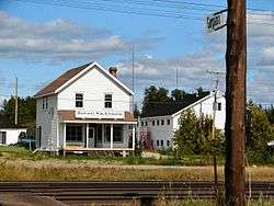 Railstop and HBC store in Gogama | |
 | |
| Coordinates: 46°30′N 80°58′W / 46.500°N 80.967°WCoordinates: 46°30′N 80°58′W / 46.500°N 80.967°W | |
| Country |
|
| Province |
|
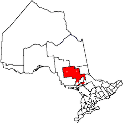
| District | Sudbury |
| Government | |
| • MP | Marc Serré (Liberal), Carol Hughes (NDP) |
| • MPP | France Gélinas (NDP), Michael Mantha (NDP) |
| Area[1] | |
| • Land | 35,594.71 km2 (13,743.19 sq mi) |
| Population (2011)[1] | |
| • Total | 2,306 |
| • Density | 0.1/km2 (0.3/sq mi) |
| Time zone | UTC-5 (EST) |
| • Summer (DST) | UTC-4 (EDT) |
| Postal code FSA | P0M |
| Area code(s) | 705 |
Unorganized North Sudbury District is an unorganized area in the Canadian province of Ontario, comprising all portions of the Sudbury District which are not organized into incorporated municipalities. Despite its name, there is no longer an accompanying "South Part", as that subdivision has subsequently been incorporated into municipalities and Statistics Canada has not renamed the North Part.
The subdivision consists of three non-contiguous areas, totalling 35,594.71 square kilometres, or about 92% of the district. It had a population of 2,306 in the Canada 2011 Census.[1]
Communities
- Benny
- Biscotasing
- Cartier
- Estaire
- Foleyet
- Gogama
- Mattagami
- Metagama
- Paget
- Shining Tree
- Sultan
- West River
- Westree
- Whitefish Falls
- Willisville
Ghost towns
Demographics
| Canada census – Sudbury, Unorganized, North Part community profile | |||
|---|---|---|---|
| 2011 | 2006 | ||
| Population: | 2306 (-4.5% from 2006) | 2415 (-17.0% from 2001) | |
| Land area: | 35,594.71 km2 (13,743.19 sq mi) | 35,481.13 km2 (13,699.34 sq mi) | |
| Population density: | 0.1/km2 (0.26/sq mi) | 0.1/km2 (0.26/sq mi) | |
| Median age: | 49.3 (M: 49.8, F: 48.9) | ||
| Total private dwellings: | 1728 | 1911 | |
| Median household income: | $49,690 | ||
| References: 2011[2] 2006[3] earlier[4] | |||
Population:[5]
- Population in 2006: 2415
- Population in 2001: 2910
- Population in 1996: 7147 (or 2929 when adjusted to 2001 boundaries)
- Population in 1991: 7463
Mother tongue:[6]
- English as first language: 60.8%
- French as first language: 32.4%
- English and French as first language: 0.8%
- Other as first language: 6.0%
See also
References
- 1 2 3 "Sudbury, Unorganized, North Part census profile". 2011 Census of Population. Statistics Canada. Retrieved 2012-02-10.
- ↑ "2011 Community Profiles". Canada 2011 Census. Statistics Canada. July 5, 2013. Retrieved 2012-02-10.
- ↑ "2006 Community Profiles". Canada 2006 Census. Statistics Canada. March 30, 2011. Retrieved 2012-02-10.
- ↑ "2001 Community Profiles". Canada 2001 Census. Statistics Canada. February 17, 2012.
- ↑ Statistics Canada: 1996, 2001, 2006 census
- ↑ Statistics Canada 2006 Census - Community Profile
Main northern part | |
|---|---|
Southwestern part | |
|---|---|
Southeastern part | ||||||||||
|---|---|---|---|---|---|---|---|---|---|---|
| ||||||||||
| Towns | 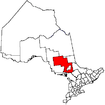 | |
|---|---|---|
| Townships | ||
| First Nations | ||
| Indian reserves | ||
| Unorganized area | ||
| Local services boards | ||
| ||
This article is issued from
Wikipedia.
The text is licensed under Creative Commons - Attribution - Sharealike.
Additional terms may apply for the media files.