Westree, Ontario
| Westree, Ontario | |
| Settlement | |
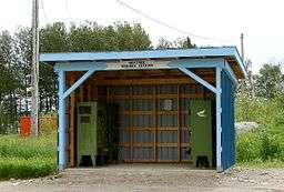 Communal mail boxes in Westree | |
| Country | Canada |
|---|---|
| Province | Ontario |
| Region | Northeastern Ontario |
| District | Sudbury |
| Municipality | Sudbury, Unorganized, North Part |
| Elevation | 405 m (1,329 ft) |
| Coordinates | 47°25′08″N 81°32′43″W / 47.41889°N 81.54528°WCoordinates: 47°25′08″N 81°32′43″W / 47.41889°N 81.54528°W |
| Timezone | Eastern Time Zone (UTC−5) |
| - summer (DST) | Eastern Time Zone (UTC−4) |
| FSA | P0M |
| Area code | 705 |
 Location of Westree in Ontario | |
Westree is an unincorporated community in the Unorganized, North Part of Sudbury District in northeastern Ontario, Canada. It is located at the end of the spur Ontario Highway 560A and lies on the north shore of Duchabani Lake about 110 kilometres (68 mi) northwest of the centre of Sudbury. The community is on the Canadian National Railway mainline, and is the location of Westree railway station served by Via Rail.
References
- "Map Sheet 12 - Sudbury" (PDF). The Official Road Map of Ontario. Ministry of Transportation of Ontario. 2010-06-08. Retrieved 2010-10-25.
This article is issued from
Wikipedia.
The text is licensed under Creative Commons - Attribution - Sharealike.
Additional terms may apply for the media files.