University Heights, Ohio
| University Heights, Ohio | |
|---|---|
| City | |
| Motto(s): "City of Beautiful Homes" | |
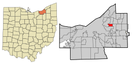 Location in Cuyahoga County and the state of Ohio. | |
.svg.png) Location of Ohio in the United States | |
| Coordinates: 41°29′42″N 81°32′13″W / 41.49500°N 81.53694°WCoordinates: 41°29′42″N 81°32′13″W / 41.49500°N 81.53694°W | |
| Country | United States |
| State | Ohio |
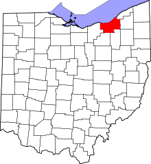
| County | Cuyahoga |
| Government | |
| • Mayor | Michael Dylan Brennan |
| Area[1] | |
| • Total | 1.82 sq mi (4.71 km2) |
| • Land | 1.82 sq mi (4.71 km2) |
| • Water | 0 sq mi (0 km2) |
| Elevation[2] | 1,027 ft (313 m) |
| Population (2010)[3] | |
| • Total | 13,539 |
| • Estimate (2012[4]) | 13,442 |
| • Density | 7,439.0/sq mi (2,872.2/km2) |
| Time zone | UTC−5 (Eastern (EST)) |
| • Summer (DST) | UTC−4 (EDT) |
| ZIP Codes | 44118, 44122 |
| Area code(s) | 216 |
| FIPS code | 39-78932[5] |
| GNIS feature ID | 1065413[2] |
| Website | http://www.universityheights.com/ |
University Heights is a city in Cuyahoga County, Ohio, United States. It borders Beachwood to the east, Cleveland Heights to the west, South Euclid to the north and Shaker Heights to the south. The population was 13,539 as of the 2010 Census. University Heights is nicknamed the "City of Beautiful Homes." University Heights is closely tied to neighboring Cleveland Heights, with the two sharing a school system, library system, post office and ZIP Code, some city services, and local media outlets. With about half the population under the age of 30, University Heights is home to one of the youngest communities in the region, including both students and families.
History
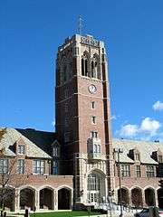
Originally part of the Warrensville Township, University Heights was incorporated as Idlewood Village in 1908. It adopted its present name in the mid-1920s, when John Carroll University was anticipated to move into the area. John Carroll attracted massive growth and University Heights soon became recognized as a city in 1940. Every summer since 1967 has begun with a Memorial Day parade which is the longest-running Memorial Day parade on the east side of Cleveland. Over time the city has become home to multiple parks, a public pool, and several commercial developments.
Geography
University Heights is located at 41°29′42″N 81°32′13″W / 41.49500°N 81.53694°W (41.495019, −81.536864).[6] According to the United States Census Bureau, the city has a total area of 1.82 square miles (4.71 km2), all land.[1]
Both branches of Dugway Brook rise in University Heights, on or near the campus of John Carroll University. All of the brook within the city was culverted in the early 20th century and now flows under the pavement. Meadowbrook Boulevard traces the winding course of the upper west branch.
Demographics
| Historical population | |||
|---|---|---|---|
| Census | Pop. | %± | |
| 1910 | 221 | — | |
| 1920 | 131 | −40.7% | |
| 1930 | 2,237 | 1,607.6% | |
| 1940 | 5,981 | 167.4% | |
| 1950 | 11,566 | 93.4% | |
| 1960 | 16,641 | 43.9% | |
| 1970 | 17,055 | 2.5% | |
| 1980 | 15,401 | −9.7% | |
| 1990 | 14,790 | −4.0% | |
| 2000 | 14,146 | −4.4% | |
| 2010 | 13,539 | −4.3% | |
| Est. 2017 | 13,028 | [7] | −3.8% |
| Sources:[8][9][5][10] | |||
The median income for a household in the city was $72,519, and the median income for a family was $88,892. The per capita income for the city was $30,081. About 6.2% of the total population were below the poverty line. Of the city's population over the age of 25, 67.0% hold a bachelor's degree or higher,[11][12] and 92.8% spoke English, 2.1% Spanish, 0.9% Yiddish, 0.9% Hebrew, and 0.7% Russian at home.[13]
2010 census
As of the census[3] of 2010, there were 13,539 people, 4,810 households, and 3,011 families residing in the city. The population density was 7,439.0 inhabitants per square mile (2,872.2/km2). There were 5,248 housing units at an average density of 2,883.5 per square mile (1,113.3/km2). The racial makeup of the city was 71.8% White, 23.1% African American, 0.1% Native American, 2.4% Asian, 0.9% from other races, and 1.6% from two or more races. Hispanic or Latino of any race were 2.8% of the population.
There were 4,810 households of which 31.9% had children under the age of 18 living with them, 48.9% were married couples living together, 10.9% had a female householder with no husband present, 2.8% had a male householder with no wife present, and 37.4% were non-families. Of all households 29.1% were made up of individuals and 10% had someone living alone who was 65 years of age or older. The average household size was 2.48 and the average family size was 3.11.
The median age in the city was 30.7 years. 22.7% of residents were under the age of 18; 19.7% were between the ages of 18 and 24; 25.8% were from 25 to 44; 20.1% were from 45 to 64; and 11.7% were 65 years of age or older. The gender makeup of the city was 47.7% male and 52.3% female.
2000 census
In 2000, there were 5,163 households out of which 29.3% had children under the age of 18 living with them, 52.9% were married couples living together, 9.3% had a female householder with no husband present, and 35.7% were non-families. Of all households 29.9% were made up of individuals and 11.7% had someone living alone who was 65 years of age or older. The average household size was 2.37 and the average family size was 2.99.
In the city, the population was spread out with 20.8% under the age of 18, 18.9% from 18 to 24, 27.8% from 25 to 44, 19.1% from 45 to 64, and 13.4% who were 65 years of age or older. The median age was 32 years. For every 100 females, there were 89.2 males. For every 100 females age 18 and over, there were 85.2 males.
Education
Colleges and universities
Public schools
Public education in the city of University Heights is provided by the Cleveland Heights-University Heights City School District. Located in University Heights are Gearity Professional Development School,[14] Cleveland Heights High School (temporary location) and Gearity Early Childhood Center.[15]
Private schools
- Gesu Catholic School
- The Bellefaire JCB provides preschool programs, childcare, counseling & education for children[16]
See also
References
- 1 2 "US Gazetteer files 2010". United States Census Bureau. Archived from the original on January 24, 2012. Retrieved 2013-01-06.
- 1 2 "US Board on Geographic Names". United States Geological Survey. 2007-10-25. Retrieved 2008-01-31.
- 1 2 "American FactFinder". United States Census Bureau. Retrieved 2013-01-06.
- ↑ "Population Estimates". United States Census Bureau. Archived from the original on June 17, 2013. Retrieved 2013-06-17.
- 1 2 "American FactFinder". United States Census Bureau. Retrieved 2008-01-31.
- ↑ "US Gazetteer files: 2010, 2000, and 1990". United States Census Bureau. 2011-02-12. Retrieved 2011-04-23.
- ↑ "Population and Housing Unit Estimates". Retrieved May 26, 2018.
- ↑ "Number of Inhabitants: Ohio" (PDF). 18th Census of the United States. U.S. Census Bureau. Retrieved 22 November 2013.
- ↑ "Ohio: Population and Housing Unit Counts" (PDF). U.S. Census Bureau. Retrieved 22 November 2013.
- ↑ "Incorporated Places and Minor Civil Divisions Datasets: Subcounty Population Estimates: April 1, 2010 to July 1, 2012". U.S. Census Bureau. Archived from the original on June 17, 2013. Retrieved 25 November 2013.
- ↑ "Archived copy". Archived from the original on 2013-03-10. Retrieved 2012-11-07.
- ↑ http://factfinder2.census.gov/faces/tableservices/jsf/pages/productview.xhtml?pid=ACS_10_5YR_DP03&prodType=table
- ↑ http://www.mla.org/map_data_results&state_id=39&place_id=78932&cty_id=
- ↑ http://www.chuh.org/gearityprofessionaldevelopmentschool_home.aspx
- ↑ http://www.chuh.org/earlychildhoodcenter_home.aspx
- ↑ http://www.bellefairejcb.org/
External links
| Wikimedia Commons has media related to University Heights, Ohio. |
Municipalities and communities of Cuyahoga County, Ohio, United States | ||
|---|---|---|
| Cities |
|  |
| Villages | ||
| Townships | ||
| Footnotes | ‡This populated place also has portions in an adjacent county or counties | |