Olmsted Township, Cuyahoga County, Ohio
| Olmsted Township, Cuyahoga County, Ohio | |
|---|---|
| Township | |
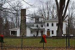 John and Maria Adams House on Columbia Road | |
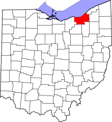
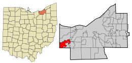 Location in Cuyahoga County and the state of Ohio. | |
.svg.png) Location of Ohio in the United States | |
| Coordinates: 41°22′50″N 81°55′17″W / 41.38056°N 81.92139°WCoordinates: 41°22′50″N 81°55′17″W / 41.38056°N 81.92139°W | |
| Country | United States |
| State | Ohio |
| County | Cuyahoga |
| Area | |
| • Total | 10.0 sq mi (25.9 km2) |
| • Land | 10.0 sq mi (25.9 km2) |
| • Water | 0.0 sq mi (0.0 km2) |
| Elevation[1] | 781 ft (238 m) |
| Population (2010) | |
| • Total | 13,513 |
| • Density | 1,400/sq mi (520/km2) |
| Time zone | UTC-5 (Eastern (EST)) |
| • Summer (DST) | UTC-4 (EDT) |
| Area code(s) | 440, 216 |
| FIPS code | 39-58408[2] |
| GNIS feature ID | 1085988[1] |
| Website | http://www.olmstedtownship.org/ |
Olmsted Township is a township located in Cuyahoga County, Ohio, United States. Situated in the southwest end of the county, Olmsted Township is a west side suburb of Cleveland, and a part of the even larger Greater Cleveland area. As of the 2010 Census, Olmsted had a population of 13,513.[3] It is one of only two civil townships remaining in Cuyahoga County, and the only Olmsted Township statewide.[4]
Geography
Located in the western part of the county, it borders the following cities and townships:
- North Olmsted - Cuyahoga County - north
- Olmsted Falls - Cuyahoga County - southeast, west of Berea
- Berea - Cuyahoga County - southeast, east of Olmsted Falls
- Brook Park - Cuyahoga County - northeast
- Columbia Township - Lorain County - south
- Eaton Township - Lorain County - southwest corner
- North Ridgeville - Lorain County - west
According to the United States Census Bureau, the township has a total area of 10.0 sq mi. All of the area consists of land, and none of it is covered with water.
Olmsted Township, is a part of the Cleveland-Elyria-Mentor Metropolitan Statistical Area which in 2010 had a population of 2,077,240. Olmsted Twp. is also part of the larger Cleveland-Akron-Elyria Combined Statistical Area, which in 2010 had a population of 2,780,440.
History
After the discovery of the New World, the land that became Olmsted Township was originally part of the French colony of Canada (New France), which was ceded in 1763 to Great Britain and renamed Province of Quebec. In the late 18th century the land became part of the Connecticut Western Reserve in the Northwest Territory, then was purchased by the Connecticut Land Company in 1795.
In 1806, the vast tract of land comprising present-day North Olmsted, Olmsted Falls and Olmsted Township was purchased for $30,000 by Aaron Olmsted, a wealthy sea captain.[5][6]
Government
The township is governed by a three-member board of trustees, who are elected in November of odd-numbered years to a four-year term beginning on the following January 1. Two are elected in the year after the presidential election and one is elected in the year before it. There is also an elected township fiscal officer,[7] who serves a four-year term beginning on April 1 of the year after the election, which is held in November of the year before the presidential election. Vacancies in the fiscal officership or on the board of trustees are filled by the remaining trustees. As of 2011, the board was composed of James Carr, Tom Bush, and Sherri Lippus and the fiscal officer was Daniel Faust.[8]
References
- 1 2 "US Board on Geographic Names". United States Geological Survey. 2007-10-25. Retrieved 2008-01-31.
- ↑ "American FactFinder". United States Census Bureau. Retrieved 2008-01-31.
- ↑ "Profile of General Population and Housing Characteristics: 2010 Demographic Profile Data (DP-1): Olmsted township, Cuyahoga County, Ohio". U.S. Census Bureau, American Factfinder. Retrieved November 23, 2011.
- ↑ "Detailed map of Ohio" (PDF). United States Census Bureau. 2000. Retrieved 2007-02-16.
- ↑ http://www.olmstedfalls.org/community.htm
- ↑ http://ech.case.edu/cgi/article.pl?id=OT1
- ↑ §503.24, §505.01, and §507.01 of the Ohio Revised Code. Accessed 4/30/2009.
- ↑ , Olmsted Township, 2011. Accessed 2011-04-17.
External links
Places adjacent to Olmsted Township, Cuyahoga County, Ohio | |
|---|---|
Municipalities and communities of Cuyahoga County, Ohio, United States | ||
|---|---|---|
| Cities |
|  |
| Villages | ||
| Townships | ||
| Footnotes | ‡This populated place also has portions in an adjacent county or counties | |