Union Township, Davis County, Iowa
| Union Township | |
|---|---|
| Township | |
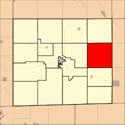 Location in Davis County | |
| Coordinates: 40°46′28″N 92°14′07″W / 40.77444°N 92.23528°WCoordinates: 40°46′28″N 92°14′07″W / 40.77444°N 92.23528°W | |
| Country |
|
| State |
|
| County | Davis |
| Area | |
| • Total | 36.56 sq mi (94.69 km2) |
| • Land | 36.52 sq mi (94.6 km2) |
| • Water | 0.04 sq mi (0.09 km2) 0.1% |
| Elevation | 758 ft (231 m) |
| Population (2000) | |
| • Total | 305 |
| • Density | 8.4/sq mi (3.2/km2) |
| GNIS feature ID | 0468817 |
Union Township is a township in Davis County, Iowa, USA. As of the 2000 census, its population was 305.
History
Union Township was organized in 1846.[1]
Geography
Union Township covers an area of 36.56 square miles (94.69 square kilometers); of this, 0.04 square miles (0.09 square kilometers) or 0.1 percent is water. The streams of Burr Oak Creek, Hickory Creek, Locke Branch and South Chequest Creek run through this township.
Unincorporated towns
- Dover (historical)
- Troy
(This list is based on USGS data and may include former settlements.)
Adjacent townships
- Salt Creek Township (north)
- Village Township, Van Buren County (northeast)
- Chequest Township, Van Buren County (east)
- Jackson Township, Van Buren County (southeast)
- Prairie Township (south)
- Cleveland Township (west)
- Perry Township (west)
- Lick Creek Township (northwest)
Cemeteries
The township contains seven cemeteries: Arney, Clark, Cupp Grave, Fountain, Richardson, Rouch and Troy.
Airports and landing strips
- Hooper Field
References
- ↑ History of Davis County, Iowa. State Historical Company. 1882. p. 428.
External links
Municipalities and communities of Davis County, Iowa, United States | ||
|---|---|---|
| Cities | ||
| Townships | ||
| Unincorporated community | ||
This article is issued from
Wikipedia.
The text is licensed under Creative Commons - Attribution - Sharealike.
Additional terms may apply for the media files.