U.S. Route 395 in Nevada
| ||||
|---|---|---|---|---|
_map.svg.png) | ||||
| Route information | ||||
| Maintained by NDOT | ||||
| Length | 85.627 mi[1] (137.803 km) | |||
| Existed | 1926–present | |||
| Major junctions | ||||
| South end |
| |||
| ||||
| North end |
| |||
| Highway system | ||||
| ||||

U.S. Route 395 (US 395) is an 85-mile-long (137 km) United States Numbered Highway near Lake Tahoe in the state of Nevada. It traverses the state after entering from California at Topaz Lake and crosses back into California near Hallelujah Junction. US 395 serves the cities of Gardnerville, Minden, Carson City and Reno. All of US 395 north of Carson City is a freeway and is built up to Interstate Highway standards. Part of the freeway section is also designated as Interstate 580 (I-580).
US 395 is an important regional highway, serving the communities of western Nevada, connecting them to other major communities via California, and it is the only major north–south arterial for the geographically isolated region.
Route description
US 395 enters Nevada at Topaz Lake as a two-lane highway and gradually winds its way to Carson Valley where it becomes the principal thoroughfare for the Minden-Gardnerville area. Upon entering the Carson Valley, US 395 becomes a four-lane highway through Minden and Gardnerville. Upon leaving Minden, the highway becomes a four-lane divided highway and turns due north towards Carson City.
At the south end of Carson City, the route intersects US 50, and the southern terminus of Interstate 580, which provide a bypass around Carson City. US 50 departs from the freeway at East William Street, while Interstate 580 begins here and heads north through Carson City concurrent with US 395.
_in_Reno%2C_Nevada.jpg)
Upon exiting Carson City, the freeway continues north through Washoe Valley and crosses through the mountains west of Washoe City and Pleasant Valley before entering Reno. Upon entering Reno, the route is designated as the Martin Luther King Jr. Freeway. The highway heads north to the I-80 interchange near Downtown Reno and I-580 ends here. Shortly afterward, US 395 turns northwest to serve the northern valleys of the greater Reno area before returning to California at Bordertown.
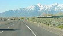
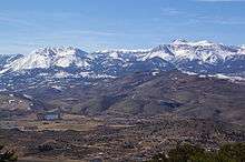
The entire route of US 395 through Nevada closely follows the eastern edge of the Sierra Nevada range. Several prominent peaks are visible from the highway, including Jobs Peak and Mount Rose.
Major intersections
- Note: Mileposts in Nevada reset at county lines. Freeway exits are numbered according to statewide mileage.
| County | Location | mi[1] | km | Exit | Destinations | Notes |
|---|---|---|---|---|---|---|
| Douglas DO 0.00–33.96 | Topaz Lake | 0.000 | 0.000 | — | Continuation into California | |
| Holbrook Junction | — | |||||
| Gardnerville | — | |||||
| Minden | — | |||||
| | — | |||||
| | — | |||||
| | — | |||||
| City of Carson City CC 0.00–9.56 | 35 | Southern end of I-580 / US 50 overlap | ||||
| Southern end of freeway | ||||||
| 38 | Fairview Drive | |||||
| 39 | Northern end of US 50 overlap | |||||
| 41 | College Parkway | Serves Carson Airport and Western Nevada College | ||||
| 42 | Arrowhead Drive | Northbound exit and southbound entrance | ||||
| 43 | Southbound exit and northbound entrance | |||||
| Washoe WA 0.00–42.10 | Washoe Valley | 44 | Eastlake Boulevard (to US 395 Alt.) | Serves Washoe Lake State Park | ||
| 46 | Bellevue Road | |||||
| Washoe City | 50 | Old US 395 (US 395 Alt., Bowers Mansion Road, Carson–Reno Highway) – Washoe City | Serves Bowers Mansion | |||
| Pleasant Valley | Galena Creek Bridge | |||||
| Reno | 56 | Also serves SR 341 (Geiger Grade) to Virginia City | ||||
| 57B | S. Virginia Street south (US 395 Alt. south) – Virginia City, Washoe City | Southbound exit and northbound entrance | ||||
| 57A | S. Virginia Street north (US 395 Alt. north / US 395 Bus. north) | Southbound exit and northbound entrance | ||||
| 59 | Damonte Ranch Parkway | |||||
| 60 | South Meadows Parkway (SR 426 west) | |||||
| 61 | S. Virginia Street (US 395 Alt. / US 395 Bus.) | |||||
| 62 | Neil Road, Meadowood Mall Way | |||||
| 63 | S. Virginia Street (US 395 Bus.), Kietzke Lane | Southbound exit and northbound entrance | ||||
| 64 | Moana Lane | Serves Reno-Sparks Convention Center | ||||
| 65 | Signed as exits 65A (Plumb Lane, Villanova Drive) and 65B (airport) southbound | |||||
| 66 | Mill Street | |||||
| 67 | E. Second Street, Glendale Avenue (SR 648) | |||||
| 68 | Northern end of I-580 overlap; signed as exits 68A (east) and 68B (west) northbound; I-80 exit 15 | |||||
| 69 | Oddie Boulevard | |||||
| 70 | N. McCarran Boulevard (SR 659), Clear Acre Lane (SR 443) – Sun Valley | Signed as exits 70A (McCarran Boulevard) and 70B (Clear Acre Lane) northbound | ||||
| 71 | Dandini Boulevard, Parr Boulevard | Serves Truckee Meadows Community College and Desert Research Institute | ||||
| 72 | ||||||
| 73 | Golden Valley Road | |||||
| 74 | Lemmon Drive | |||||
| 76 | Stead Boulevard (SR 673 south) | Serves Reno Stead Airport | ||||
| 78 | Red Rock Road | |||||
| 80 | Cold Springs Valley (White Lakes Parkway) | |||||
| 83 | Bordertown (Village Parkway) | |||||
| 85.627 | 137.803 | — | Northern end of freeway; continuation into California | |||
1.000 mi = 1.609 km; 1.000 km = 0.621 mi
| ||||||

Special routes
Current
- U.S. Route 395 Alternate, an alternate route between Carson City and Reno
- U.S. Route 395 Business, a business route in Carson City
- U.S. Route 395 Business, a little-signed business route in Reno
- U.S. Route 395 Temporary, a current temporary route on Fairview Drive
Former
- U.S. Route 395 Alternate, a former alternate route of US 395 on Sierra Street in Reno
- U.S. Route 395 Temporary, a former temporary route mostly on Kietzke Lane in Reno
See also


References
- 1 2 Nevada Department of Transportation (January 2018). "State Maintained Highways of Nevada: Descriptions and Maps". Retrieved October 6, 2018.
External links
| Wikimedia Commons has media related to U.S. Route 395 in Nevada. |
| Previous state: California |
Nevada | Next state: California |