U.S. Route 17 in Georgia
| |||||||
|---|---|---|---|---|---|---|---|
| Route information | |||||||
| Maintained by GDOT | |||||||
| Length | 124.20 mi[1] (199.88 km) | ||||||
| Existed | 1926[2][3]–present | ||||||
| History | SR 25 established at least as early as 1919[4] | ||||||
| Major junctions | |||||||
| South end |
| ||||||
| North end |
| ||||||
| Location | |||||||
| Counties | Camden, Glynn, McIntosh, Liberty, Bryan, Chatham | ||||||
| Highway system | |||||||
| |||||||

U.S. Route 17 (US 17) is a 124.20-mile-long (199.88 km) U.S. Highway in the U.S. state of Georgia. It travels south-to-north near the Atlantic Ocean, serving the Brunswick and Savannah metropolitan areas on its path from Florida at the St. Marys River to South Carolina at the Savannah River. Except for part of the highway in Savannah, which is concurrent with Interstate 16 (I-16; internally designated as SR 404) and SR 404 Spur to the Talmadge Memorial Bridge to Hutchinson Island, US 17 is concurrent with State Route 25. SR 25 uses an older western alignment of US 17 into South Carolina.
US 17 formerly traveled on part of what is now SR 303 west of Brunswick and US 25/US 341/SR 27 in the city. A portion of US 17 in Savannah was formerly US 17 Alt. US 17/SR 25, as well as US 80/SR 26 in Savannah utilized portions of Montgomery Street, West Broad Street (now known as Martin Luther King Jr. Boulevard), and Bay Street, through the central part of the city. The portion of US 17 concurrent with I-16 and SR 404 Spur (on the Talmadge Memorial Bridge) were formerly part of US 17 Alt.
Route description
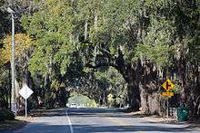
All of US 17 in Georgia that does not have a local street name is known as Ocean Highway (alternatively spelled "Ocean Hiway"), which was the name of an auto trail established in 1935 connecting Jacksonville, Florida with New York, New York.[5] The Georgia General Assembly made the Ocean Hiway designation official in a 1958 resolution that recognized the concerted advertising effort of the Ocean Hiway Association, its impact on tourism, and the signage of the highway in the coastal states to the north.[6] US 17 travels concurrently with SR 25 for almost its entire length in the state. The highways split at the I-16/I-516 interchange in Savannah; US 17 follows I-16 and its unsigned companion SR 404 and then signed SR 404 Spur to the South Carolina state line at the Savannah River, while SR 25 heads northwest along the old route of US 17 to Port Wentworth to cross the river upstream from the city. US 17 is a part of the National Highway System from I-95 west of Brunswick to SR 25 Spur in Brunswick, and from a point about halfway between Midway and Richmond Hill to the South Carolina state line.[7][8]
Kingsland to Brunswick
US 17 enters Camden County from Nassau County, Florida by crossing the St. Marys River on a through truss bridge. The two-lane highway closely parallels the First Coast Railroad, formerly part of the Seaboard Air Line Railroad (now CSX Transportation) through the southern part of the county. US 17 crosses Catfish Creek before entering the city of Kingsland. The U.S. Highway travels through the city as Lee Street, which crosses the St. Mary's Railroad at its junction with the First Coast line just south of SR 40 (King Street), which parallels the railroad east to St. Marys. Leaving Kingsland, the highway intersects a spur from the rail line and crosses the main flow and the North Fork Crooked River. US 17 parallels the First Coast Railroad to its terminus at the hamlet of Seals. The highway travels through Colesburg before entering the city of Woodbine, the county seat of Camden County. Within the city, US 17 follows four-lane divided Bedell Avenue, which intersects SR 25 Spur (10th Street), a connector between the center of town and I-95. The highway intersects and begins to travel concurrently with SR 110 (4th Street) within the Woodbine Historic District. US 17 and SR 110 reduce to two lanes and leave town by crossing the Satilla River.[9][10]

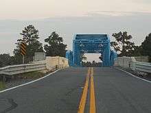
US 17 and SR 110 cross Piney Island Creek and meet the eastern terminus of SR 252 (Burnt Fort Road) at the hamlet of White Oak just south of White Oak Creek. The U.S. Highway and state route cross Waverly Creek then diverge at Waverly. US 17 curves east and enters Glynn County by crossing the Little Satilla River at Spring Bluff. The U.S. Highway curves north and within a suburban area has a four-way intersection with US 82/SR 520 (South Georgia Parkway) and the southern terminus of SR 303 (Blythe Island Highway). US 17 turns east onto four-lane divided South Georgia Parkway, here also known as Jekyll Island Road, to travel concurrently with US 82/SR 520. The concurrency with US 82 ends at that highway's eastern terminus at a partial cloverleaf interchange with I-95. US 17 and SR 520 cross Fancy Bluff Creek onto Colonel's Island and the highway becomes undivided at its crossing of the Golden Isles Terminal Railroad between a pair of automobile manufacturing plants. The highway becomes divided again shortly before SR 520 splits east as Jekyll Island Road toward Jekyll Island as US 17 curves north to cross the Brunswick River on the cable-stayed Sidney Lanier Bridge into the city of Brunswick.[9][10]
Brunswick to Richmond Hill

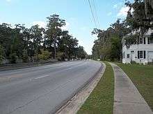
US 17 heads along the eastern edge of Brunswick as Glynn Avenue, a controlled-access four-lane divided highway that has junctions with the southern termini of US 341/SR 27 (4th Avenue) and US 25/SR 25 Conn. (Gloucester Street). The highway gains a third lane southbound at US 25/SR 25 Conn. and a third lane northbound at the F.J. Torras Causeway to St. Simons Island, which is unsigned SR 25 Spur E. US 17 crosses Cypress Mill Creek and leaves the city limits just south of its directional intersection with SR 25 Conn. (Golden Isles Parkway), which connects US 17 with I-95. There is no direct access from southbound SR 25 Conn. to northbound US 17; that movement is made via the U.S. Highway's junction with the northern terminus of SR 303 (Cypress Mill Road). The U.S. Highway continues north with four lanes through a suburban area north of Brunswick. US 17 reduces to two lanes just north of Chapel Crossing Road to the east of the Federal Law Enforcement Training Center. The U.S. Highway re-enters a rural area as it passes to the east of Brunswick Golden Isles Airport. US 17 begins to travel concurrently with I-95 Bus./SR 99 and travels along the edge of the Hofwyl-Broadfield Plantation Historic Site before crossing the South Altamaha River into McIntosh County.[9][10]
I-95 Bus., US 17, and SR 99 travel through the Altamaha Waterfowl Management Area, during which the highways traverse Champney Island, Butler Island, and Generals Island. The highways cross between the islands by crossing the Champney River and the Butler River, which are branches of the Altamaha River, and the Darien River, where the highways enter the city of Darien, the county seat of McIntosh County, as Walton Street. In the center of town, SR 99 splits east onto Adams Street and I-95 Bus./US 17 continues as North Way, which is a four-lane undivided street in the city. North of the city limits, I-95 Bus. splits west along SR 251 and the U.S. Highway reduces to two lanes and passes Eden Field Airport. US 17 crosses a pair of swamps around the hamlet of Ardick and intersects SR 99 (Ridge Road) again at Eulonia. The highway crosses the Sapelo River and Buck Hill Swamp on its way to its crossing of the South Newport River at South Newport.[9][10]
US 17 continues north through Liberty County and meets I-95 at a diamond interchange. The highway enters the sparsely populated city of Riceboro at Payne Creek. US 17 temporarily expands to four lanes between its crossing of the Riceboro Southern Railway, which is part of the former Seaboard Air Line corridor, and its intersection with the eastern terminus of SR 119 (E.B. Cooper Highway). At the north end of town, the highway crosses Riceboro Creek. US 17 crosses Peacock Creek and enters the city of Midway at Porter Creek. US 17 intersects US 84/SR 38 (Oglethorpe Highway) in the center of town. The U.S. Highway expands to a four-lane divided highway at its intersection with SR 196 (Leroy Coffer Highway) just before crossing Mount Hope Creek, a tributary of the Jerico River, at the Liberty–Bryan county line. US 17 enters a suburban area and parallels the city limits of Richmond Hill, which is immediately to the west, until the highway enters the city proper just before its partial cloverleaf interchange with I-95. The U.S. Highway crosses over CSX's Nahunta Subdivision and intersects SR 144 (Ford Avenue) before leaving the city and entering Chatham County by crossing the Ogeechee River at Kings Ferry.[9][10]
Richmond Hill to Savannah
US 17 continues northeast as Ogeechee Road through a suburban area. The U.S. Highway meets SR 204 (Abercorn Expressway) at a diamond interchange in the suburb of Georgetown then crosses the Little Ogeechee River. US 17 meets the southern terminus of SR 307 (Dean Forest Road) just west of Salt Creek, then continues east as a five-lane road with center turn lane. The highway crosses over CSX's Nahunta Subdivision before reaching I-516/SR 21 (W.F. Lynes Parkway) at a diamond interchange the city limit of Savannah. Ogeechee Road continues toward downtown Savannah as US 80/SR 26; both U.S. Highways head north from the interchange on four-lane I-516. The freeway has a partial interchange with Tremont Street (southbound exit, northbound entrance), which serves the Savannah Amtrak station, and crosses CSX's Savannah Subdivision before its interchange with I-16 (Jim Gillis Historic Savannah Parkway). US 17 heads east on six-lane I-16 while US 80, SR 21, SR 25, and SR 26 continue north concurrent with I-516.[9][10]
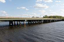
I-16 and US 17 have a partial interchange with the eastern terminus of SR 204, then curve northeast. The U.S. Highway diverges from I-16 one interchange west of the Interstate's eastern terminus and just south of a partial interchange (northbound exit, southbound entrance) with Gwinnett Street. Four-lane US 17, which is also signed as SR 404 Spur, travels through another pair of partial interchanges: a northbound exit, southbound entrance for Louisville Road and southbound exit, northbound entrance for a spur to Oglethorpe Street. North of the latter interchange, US 17 ascends onto the cable-stayed Tallmadge Memorial Bridge, which crosses over Bay Street and the main channel of the Savannah River. The U.S. Highway descends onto Hutchinson Island, crosses over Wayne Shackelford Boulevard and the Savannah Port Terminal Railroad, and has a partial cloverleaf interchange with the boulevard, which leads to the Savannah Convention Center. Within the interchange, US 17 reduces to two lanes and crosses the Back River, another branch of the Savannah River, on a low-level bridge into Jasper County, South Carolina.[9][10]
History
1920s to 1940s
SR 25 was established at least as early as 1919, but only from Brunswick to Darien. At this time, SR 27 was established from SR 40 west-northwest of St. Marys to a point northwest of Brunswick. Also, SR 30 was established from southeast of Clyde to Savannah.[4] By the end of September 1921, SR 25 was extended from Darien to southeast of Clyde. SR 27's path from west-northwest of St. Marys to northwest of Brunswick was decommissioned; it was then proposed on a more western path from SR 40 in Kingsland to SR 50 northwest of Brunswick. An unnumbered road was established from SR 21 northwest of Savannah east-northeast to the South Carolina state line.[4][2] By October 1926, the proposed path of SR 27, from Kingsland to northwest of Brunswick, was redesignated as US 17/SR 25. There was no indication if this segment connected with the portion from Brunswick to the Savannah area. SR 25 was extended northeast on the former path of SR 30 from southeast of Clyde to Savannah, northwest on SR 21 to the previously unnumbered road, and on this road to the South Carolina state line. US 17 was designated on SR 25 from Brunswick to the state line.[2][3] Between October 1929 and June 1930, the entire length of US 17/SR 25 that existed at the time had a "completed hard surface".[11][12] The 1938 GDOT map, which was the first one that had an inset map of Savannah, indicated that US 17/SR 25 entered the city on Victory Drive. They turned left onto Montgomery Street and traveled to the north-northeast. At 37th Street, US 80/SR 26 joined the concurrency. At Liberty Street, US 80/SR 26 departed the concurrency to the west-northwest, along with US 280, which ended at this intersection at the time. At Bay Street, US 17/SR 25 turned left onto the southern part of SR 21, which began at this intersection, and traveled to the west-northwest.[13][14] Between the beginning of 1945 and November 1946, US 17/SR 25 were indicated to enter Savannah on Ogeechee Road. They turned right onto 37th Street and traveled to the east-southeast. They turned left onto Montgomery Street and traveled north-northeast with US 80/SR 26. The four highways turned left on SR 21 (Bay Street). All five highways traveled to the west-northwest.[15][16] By February 1948, US 17/SR 25 were then indicated to enter Savannah on Ogeechee Road. They turned right onto 52nd Street and traveled to the east-southeast. They turned left onto Whatley Avenue and traveled to the northeast. They curved to the north-northeast on Montgomery Street and traveled to the north-northeast. At 37th Street, US 80/SR 26 joined the concurrency. The highways continued as before.[16][17]
1950s to 1990s
Between April 1949 and August 1950, US 17/SR 25 was reverted to its 1946 routing, on Ogeechee Road, 37th Street, Montgomery Street, and Bay Street. The former path was redesignated as SR 25 Spur.[18][19] In 1953, the path of US 17/SR 25, on Ogeechee Road and 37th Street, became the southbound lanes of these highways. The path of US 17 Alt., on Mills B. Lane Boulevard, Whatley Avenue, and Montgomery Street, became the northbound lanes of US 17/SR 25 Spur.[20][21] Between June 1954 and June 1955, the lanes of northbound US 17/SR 25 and westbound US 80/SR 26 utilized Montgomery Street as before, while the lanes of southbound US 17/SR 25 and eastbound US 80/SR 26 utilized West Broad Street.[22][23] Between July 1957 and June 1960, the path of US 17/SR 25 in the Brunswick area was shifted southeastward, onto the path of US 84/SR 50, replacing the path of SR 25 Spur. The former path became parts of SR 303 and US 25/US 341/SR 27.[24][25] By June 1963, the southbound lanes of US 17/SR 25, in Savannah, were shifted south-southwestward, off of 37th Street and onto Victory Street. SR 26 Loop was proposed from US 17/SR 25 southwest of the city north-northeast to US 17/US 80/SR 25/SR 26 just northwest of it.[25][26] In 1966, SR 26 Loop was under construction from US 17/SR 25 to Augusta Avenue.[27][28] The next year, the portion of SR 26 Loop from US 17/SR 25 to I-16 was indicated to "open spring '68".[28][29] In 1968, SR 26 Loop was open on this segment.[29][30] The next year, SR 26 Loop was open from I-16 to Augusta Avenue.[30][31] In 1970, SR 26 Loop was proposed to be extended north-northeast and west-northwest to US 17/US 80/SR 25/SR 26 just southeast of Fair Street.[31][32] In 1977, SR 26 Loop was completed on this proposed extension.[33][34] The next year, SR 26 Loop was redesignated as a southern extension of SR 21.[34][35] In 1985, I-516 was designated on most of SR 21 in Savannah. US 17/US 80/SR 25/SR 26 was shifted onto I-516/SR 21 north of the Ogeechee Road interchange.[36][37] In 1988, SR 404 Spur was proposed from I-16 from just east of I-16's interchange with SR 204 in Savannah and then east-northeast, north-northwest, and north-northeast to US 17 Alt./SR 25 Alt. on Hutchinson Island, just south of the South Carolina state line. The path of SR 50 was truncated out of the Brunswick area. Its former path in the area was redesignated as SR 520.[38][39] The next year, the paths of US 82 and US 84 east of Waycross were swapped, to their current paths, thus truncating US 84 in the Brunswick area to its current eastern terminus.[39][40] In 1995, the path of US 17, from Savannah to Hardeeville, South Carolina, was shifted southeastward, replacing the path of US 17 Alt. The South Carolina portion was redesignated as a western extension of South Carolina Highway 170.[41][42]
The section of US 17 known as the "Gateway to Historic Brunswick and The Golden Isles" was included in The Georgia Trust for Historic Preservation's 2006 list of Places in Peril.
Major intersections
| County | Location | mi | km | Exit | Destinations | Notes |
|---|---|---|---|---|---|---|
| Camden | | 0.00 | 0.00 | Southern terminus of US 17 and SR 25 in Georgia; Florida state line at St. Marys River | ||
| Kingsland | 4.06 | 6.53 | ||||
| Woodbine | 15.23 | 24.51 | Western terminus of SR 25 Spur | |||
| 15.77 | 25.38 | |||||
| White Oak | 20.22 | 32.54 | Eastern terminus of SR 252 | |||
| Waverly | 24.53 | 39.48 | ||||
| Glynn | | 34.23 | 55.09 | South end of US 82 and SR 520 concurrencies; southern terminus of SR 303 | ||
| | 34.93 | 56.21 | I-95 exit 29; eastern terminus of US 82 | |||
| | 40.30 | 64.86 | North end of SR 520 concurrency | |||
| | 40.6– 42.0 | 65.3– 67.6 | Sidney Lanier Bridge over the Brunswick River | |||
| Brunswick | Southern terminus of US 341/SR 27 | |||||
| Southern terminus of US 25/SR 25 Conn. | ||||||
| F.J. Torras Causeway (SR 25 Spur E east) – St. Simons Island, Sea Island | Western terminus of unsigned SR 25 Spur E | |||||
| Southern terminus of SR 25 Spur; no direct access from southbound SR 25 Spur to northbound US 17 | ||||||
| Northern terminus of SR 303 | ||||||
| | South end of I-95 Bus. and SR 99 concurrencies | |||||
| McIntosh | Darien | 60.27 | 97.00 | North end of SR 99 concurrency | ||
| | 61.38 | 98.78 | North end of I-95 Bus. concurrency; southern terminus of SR 251 | |||
| Eulonia | 71.37 | 114.86 | ||||
| Liberty | | 80.71 | 129.89 | I-95 exit 67 | ||
| Riceboro | 87.63 | 141.03 | Southern terminus of SR 119 | |||
| Midway | 91.89 | 147.88 | ||||
| | Eastern terminus of SR 196 | |||||
| Bryan | Richmond Hill | 103.02 | 165.79 | I-95 exit 87 | ||
| 104.93 | 168.87 | |||||
| Chatham | Georgetown | Interchange | ||||
| Garden City | Southern terminus of SR 307 | |||||
| Savannah | ||||||
| 118.08 | 190.03 | 3 | South end of I-516/US 80/SR 21/SR 26 concurrency; US 17 south follows exit 3. | |||
| 4 | Tremont Avenue to Amtrak Station | Southbound exit and northbound entrance | ||||
| 119.56 | 192.41 | I-516 exit 5; I-16 exit 164 | North end of I-516/US 80/SR 21/SR 25/SR 26 concurrency; south end of I-16 concurrency; US 17 north follows exit 5; US 17 south follows exit 164A; Signed as exits 164A (I-516 North), & 164B (I-516 South) on I-16. | |||
| 120.39 | 193.75 | 165 | Northbound exit and southbound entrance; eastern terminus of SR 204. | |||
| 120.94 | 194.63 | 166 | Northbound exit and southbound entrance; north end of I-16 concurrency; south end of SR 404 Spur concurrency; southern terminus of SR 404 Spur; US 17 north follows exit 166. | |||
| 121.32 | 195.25 | Gwinnett Street | Interchange; northbound exit and southbound entrance | |||
| 121.66 | 195.79 | Louisville Road – Visitors Center | Interchange; northbound exit and southbound entrance | |||
| 122.10 | 196.50 | Interchange; southbound exit and northbound entrance | ||||
| Talmadge Memorial Bridge over Savannah River | ||||||
| 123.44 | 198.66 | Hutchinson Island, Convention Center | Interchange | |||
| 124.01 | 199.57 | South Carolina state line (Back River bridge); northern end of SR 404 concurrency; northern terminus of SR 404 Spur | ||||
1.000 mi = 1.609 km; 1.000 km = 0.621 mi
| ||||||
Future
US 17 is scheduled to be widened in northern Glynn County in the coming years. The Georgia Department of Transportation is currently planning to convert the highway from a two-lane undivided road to a four-lane divided highway for a 6-mile-long (9.7 km) segment from Yacht Drive where it currently becomes two lanes north to SR 99. This segment of highway frequently gets congested during peak hours, lacks left turn lanes, and has had a high rate of accidents in recent years. According to GDOT, construction will begin around 2020.[43]
Related routes
SR 25
| |
|---|---|
| Location | Kingsland–Port Wentworth |
| Length | 129.07 mi[1] (207.72 km) |
State Route 25 (SR 25) is US 17's companion route along much of the U.S. Highway's course through Georgia. The state highway has a total length of 129.07 miles (207.72 km); the highway travels concurrently with US 17 for 119.56 miles (192.41 km) from the Florida state line south of Kingsland north to Savannah.[1][9] SR 25 has a length of 9.51 miles (15.30 km) from its split with US 17 in Savannah to the South Carolina state line near Port Wentworth.[1][44]
SR 25 splits from US 17 at the I-16/I-516 interchange in Savannah. US 17 heads east with I-16 (Jim Gillis Historic Savannah Parkway) toward downtown Savannah and the Talmadge Memorial Bridge. SR 25 continues north on I-516 (W.F. Lynes Parkway), a four-lane freeway that also carries US 80, SR 21, SR 26, and the unsigned SR 421. The freeway has a half-diamond interchange with Gwinnett Street, which connects downtown Savannah with the Savannah Amtrak station. The interchange allows access to and from the south. After crossing a rail line belonging to the Savannah Port Terminal Railroad, I-516, SR 21, and SR 25 diverge from US 80 and SR 26 and meet the western end of SR 25 Conn. at another partial interchange. The southern part of the interchange includes ramps from northbound SR 25 to Augusta Street and from Augusta Street to southbound SR 25; Augusta Street serves as a connector to Bay Street, on which US 80/SR 26 heads west and SR 25 Conn. heads east. The interchange also includes ramps from southbound SR 25 to SR 25 Conn., SR 25 Conn. to northbound SR 25, and from northbound SR 25 to Lathrop Avenue, which serves an industrial area along the Savannah River.[10][44]
Within the interchange with US 80/SR 26 and SR 25 Conn., I-516, SR 21, and SR 25 curve northwest. The highways cross CSX's Charleston Subdivision and parallel Bay Street toward the northern terminus of I-516 at a partial cloverleaf interchange with Burnseed Boulevard on the boundary of the cities of Savannah and Garden City. SR 25 exits onto the four-lane connector between US 80/SR 26 and Main Street; SR 21 continues northwest as the freeway transitions to Augusta Road, a four-lane divided highway. SR 25 turns northwest onto Main Street, a five-lane road with center turn lane, crosses a canal, and parallels a portion of the port railroad. The highway reduces to two lanes at its intersection with SR 21 Spur (Brampton Road), which heads into the Port of Savannah. SR 25 curves north as it crosses a pair of intersecting rail lines and passes between the port property to the east and a residential area of Garden City to the west.[10][44]
SR 25 meets the northern end of SR 307 (Bourne Avenue) just after leaving Garden City. The highway continues as Coastal Highway into Port Wentworth, the site of the 2008 Georgia sugar refinery explosion. SR 25 meets the eastern end of SR 30 (Bonnybridge Road) before leaving Port Wentworth and curving east around the northern end of an industrial area. The highway crosses the Front River, the main channel of the Savannah River, on the Houlihan Bridge, a through truss swing bridge. SR 25 continues east across Onslow Island, crosses the Middle River, cuts through Argyle Island, then crosses the Little Back River into South Carolina. The highway continues as South Carolina Highway 170 (SC 170), which intersects US 17 south of Hardeeville.[10][44]
See also

.svg.png)
- Special routes of U.S. Route 17
References
- 1 2 3 4 Geographic Transportation Reporting Analysis and Query System (GeoTRAQS) (Map). Georgia Department of Transportation. Archived from the original on December 27, 2012. Retrieved May 11, 2012.
- 1 2 3 State Highway Department of Georgia (1921). System of State Roads (PDF) (Map). Scale not given. Atlanta: State Highway Department of Georgia. Retrieved June 26, 2017.
- 1 2 State Highway Department of Georgia (October 1926). System of State Roads (PDF) (Map). Scale not given. Atlanta: State Highway Department of Georgia. Retrieved June 26, 2017.
- 1 2 3 State Highway Department of Georgia (1920). System of State Aid Roads as Approved Representing 4800 Miles of State Aid Roads Outside the Limits of the Incorporated Towns (PDF) (Map). Scale not given. Atlanta: State Highway Department of Georgia. Retrieved June 26, 2017.
- ↑ Staff (January 15, 1956). "Ocean Hiway Now Improved". Sunday Herald. Bridgeport, Connecticut: Bridgeport Herald Corporation. p. 13. Retrieved April 22, 2012.
- ↑ Georgia General Assembly (March 17, 1958). "Ocean Hway — Designated" (PDF). Acts and Resolutions of the General Assembly of the State of Georgia 1958. p. 143. Retrieved May 10, 2012.
- ↑ National Highway System: Brunswick, GA (PDF) (Map). Federal Highway Administration. March 25, 2015. Retrieved December 29, 2016.
- ↑ National Highway System: Savannah, GA (PDF) (Map). Federal Highway Administration. March 25, 2015. Retrieved December 29, 2016.
- 1 2 3 4 5 6 7 8 Google (April 8, 2012). "U.S. Route 17 in Georgia" (Map). Google Maps. Google. Retrieved April 8, 2012.
- 1 2 3 4 5 6 7 8 9 10 Office of Transportation Data. "County Maps". Georgia Department of Transportation. Retrieved April 22, 2012.
- ↑ State Highway Department of Georgia (October 1929). System of State Roads (PDF) (Map). Scale not given. Atlanta: State Highway Department of Georgia. Retrieved June 26, 2017.
- ↑ State Highway Department of Georgia (June 1930). System of State Roads (PDF) (Map). Scale not given. Atlanta: State Highway Department of Georgia. Retrieved June 26, 2017.
- ↑ State Highway Department of Georgia (October 1, 1937). System of State Roads (PDF) (Map). Scale not given. Atlanta: State Highway Department of Georgia. Retrieved June 26, 2017.
- ↑ Georgia State Highway Board (January 1, 1938). System of State Roads (PDF) (Map). Scale not given. Atlanta: State Highway Department of Georgia. OCLC 5673161. Retrieved June 26, 2017.
- ↑ State Highway Department of Georgia (January 1, 1945). System of State Roads (PDF) (Map). Scale not given. Atlanta: State Highway Department of Georgia. OCLC 5673161. Retrieved June 26, 2017.
- 1 2 State Highway Department of Georgia (1946). System of State Roads (PDF) (Map). Scale not given. Atlanta: State Highway Department of Georgia. OCLC 5673161. Retrieved June 26, 2017. (Corrected to November 7, 1946.)
- ↑ State Highway Department of Georgia (1948). System of State Roads (PDF) (Map). Scale not given. Atlanta: State Highway Department of Georgia. OCLC 5673161. Retrieved June 26, 2017. (Corrected to February 28, 1948.)
- ↑ State Highway Department of Georgia (1949). System of State Roads (PDF) (Map). Scale not given. Atlanta: State Highway Department of Georgia. OCLC 5673161. Retrieved June 26, 2017. (Corrected to April 1, 1949.)
- ↑ State Highway Department of Georgia (1950). System of State Roads (PDF) (Map). Scale not given. Atlanta: State Highway Department of Georgia. OCLC 5673161. Retrieved June 26, 2017. (Corrected to August 1, 1950.)
- ↑ State Highway Department of Georgia (January 1, 1953). System of State Roads (PDF) (Map). Scale not given. Atlanta: State Highway Department of Georgia. Retrieved June 26, 2017. (Corrected to January 1, 1953.)
- ↑ State Highway Department of Georgia (1953). State Highway System and Other Principal Connection Roads (PDF) (Map). Scale not given. Atlanta: State Highway Department of Georgia. OCLC 5673161. Retrieved June 26, 2017. (Corrected to September 1, 1953.)
- ↑ State Highway Department of Georgia (1954). State Highway System and Other Principal Connection Roads (PDF) (Map). Scale not given. Atlanta: State Highway Department of Georgia. OCLC 5673161. Retrieved June 26, 2017. (Corrected to June 1, 1954.)
- ↑ State Highway Department of Georgia (1955). State Highway System and Other Principal Connection Roads (PDF) (Map). Scale not given. Atlanta: State Highway Department of Georgia. OCLC 5673161. Retrieved June 26, 2017. (Corrected to June 1, 1955.)
- ↑ State Highway Department of Georgia (1957). State Highway System and Other Principal Connection Roads (PDF) (Map). Scale not given. Atlanta: State Highway Department of Georgia. OCLC 5673161. Retrieved June 26, 2017. (Corrected to July 1, 1957.)
- 1 2 State Highway Department of Georgia (1960). State Highway System and Other Principal Connection Roads (PDF) (Map) (1960–1961 ed.). Scale not given. Atlanta: State Highway Department of Georgia. OCLC 5673161. Retrieved June 26, 2017. (Corrected to June 1, 1960.)
- ↑ State Highway Department of Georgia (1963). State Highway System and Other Principal Connection Roads (PDF) (Map). Scale not given. Atlanta: State Highway Department of Georgia. OCLC 5673161. Retrieved June 26, 2017. (Corrected to June 1, 1963.)
- ↑ State Highway Department of Georgia (January 1966). Official Highway Map (PDF) (Map). Scale not given. Atlanta: State Highway Department of Georgia. Retrieved June 26, 2017.
- 1 2 State Highway Department of Georgia (January 1967). Official Highway Map (PDF) (Map). Scale not given. Atlanta: State Highway Department of Georgia. Retrieved June 26, 2017.
- 1 2 State Highway Department of Georgia (January 1968). Official Highway Map (PDF) (Map). Scale not given. Atlanta: State Highway Department of Georgia. Retrieved June 26, 2017.
- 1 2 State Highway Department of Georgia (January 1969). Official Highway Map (PDF) (Map). Scale not given. Atlanta: State Highway Department of Georgia. Retrieved June 26, 2017.
- 1 2 State Highway Department of Georgia (January 1970). Official Highway Map (PDF) (Map). Scale not given. Atlanta: State Highway Department of Georgia. Retrieved June 27, 2017.
- ↑ State Highway Department of Georgia (January 1971). Official Highway Map (PDF) (Map). Scale not given. Atlanta: State Highway Department of Georgia. Retrieved June 27, 2017.
- ↑ Georgia Department of Transportation (January 1977). Official Highway Map (PDF) (Map) (1977–1978 ed.). Scale not given. Atlanta: Georgia Department of Transportation. Retrieved June 27, 2017.
- 1 2 Georgia Department of Transportation (January 1977). Official Highway Map (PDF) (Map) (1977–1978 ed.). Scale not given. Atlanta: Georgia Department of Transportation. Retrieved June 27, 2017.
- ↑ Georgia Department of Transportation (January 1978). Official Highway Map (PDF) (Map) (1978-79 ed.). Scale not given. Atlanta: Georgia Department of Transportation. Retrieved June 27, 2017.
- ↑ Georgia Department of Transportation (1984). Official Highway and Transportation Map (PDF) (Map) (1984–1985 ed.). Scale not given. Atlanta: Georgia Department of Transportation. Retrieved June 27, 2017.
- ↑ Georgia Department of Transportation (1986). Official Highway and Transportation Map (PDF) (Map) (1986–1987 ed.). Scale not given. Atlanta: Georgia Department of Transportation. Retrieved June 27, 2017.
- ↑ Georgia Department of Transportation (1988). Official Highway and Transportation Map (PDF) (Map) (1988–1989 ed.). Scale not given. Atlanta: Georgia Department of Transportation. Retrieved June 27, 2017.
- 1 2 Georgia Department of Transportation (1989). Official Highway and Transportation Map (PDF) (Map) (1989–1990 ed.). Scale not given. Atlanta: Georgia Department of Transportation. Retrieved June 27, 2017.
- ↑ Georgia Department of Transportation (1990). Official Highway and Transportation Map (PDF) (Map) (1990–1991 ed.). Scale not given. Atlanta: Georgia Department of Transportation. Retrieved June 27, 2017.
- ↑ Georgia Department of Transportation (1995). Official Highway and Transportation Map (PDF) (Map) (1995–1996 ed.). Scale not given. Atlanta: Georgia Department of Transportation. Retrieved June 27, 2017.
- ↑ Georgia Department of Transportation (1996). Official Highway and Transportation Map (PDF) (Map) (1996–1997 ed.). Scale not given. Atlanta: Georgia Department of Transportation. Retrieved June 27, 2017.
- ↑ Story, Brent (January 15, 2014). "Approved Revised Concept Report" (PDF). Georgia State Department of Transportation. Retrieved June 26, 2017.
- 1 2 3 4 Google (April 27, 2012). "Georgia State Route 25" (Map). Google Maps. Google. Retrieved April 27, 2012.
External links
Route map:
| Wikimedia Commons has media related to U.S. Route 17 in Georgia. |
| Previous state: Florida |
Georgia | Next state: South Carolina |