Drag, Norway
| Ájluokta Ájluokta Drag | |
|---|---|
| Village | |
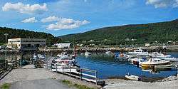 View of the village harbor | |
 Ájluokta Location in Nordland  Ájluokta Ájluokta (Norway) | |
| Coordinates: 68°02′40″N 16°04′46″E / 68.04444°N 16.07944°ECoordinates: 68°02′40″N 16°04′46″E / 68.04444°N 16.07944°E | |
| Country | Norway |
| Region | Northern Norway |
| County | Nordland |
| District | Ofoten |
| Municipality | Tysfjord |
| Area[1] | |
| • Total | 0.47 km2 (0.18 sq mi) |
| Elevation[2] | 8 m (26 ft) |
| Population (2013)[1] | |
| • Total | 870 |
| • Density | 670/km2 (1,700/sq mi) |
| Time zone | UTC+01:00 (CET) |
| • Summer (DST) | UTC+02:00 (CEST) |
| Post Code | 8270 Drag |
Drag (Lule Sami: Ájluokta and Northern Sami: Áiluokta) is a village in the municipality of Tysfjord in Nordland county, Norway. It is located along the Tysfjorden, about 200 kilometres (120 mi) north of Bodø and about 120 kilometres (75 mi) south of Narvik. The 0.47-square-kilometre (120-acre) village has a population (2013) of 315. The population density is 670 inhabitants per square kilometre (1,700/sq mi).[1]
Drag is located along Norwegian National Road 827 runs through Drag to a ferry port that connects to the village of Kjøpsvik across the fjord. Árran, the national Lule Sami Center is located in Drag. The Drag/Helland Church is located just outside the village of Drag.[3]
References
- 1 2 3 Statistisk sentralbyrå (1 January 2013). "Urban settlements. Population and area, by municipality".
- ↑ "Drag" (in Norwegian). yr.no. Retrieved 2012-05-15.
- ↑ Store norske leksikon. "Drag" (in Norwegian). Retrieved 2012-05-14.
This article is issued from
Wikipedia.
The text is licensed under Creative Commons - Attribution - Sharealike.
Additional terms may apply for the media files.