Tylersville, Pennsylvania
| Tylersville, Pennsylvania | |
|---|---|
| Unincorporated community | |
 Tylersville | |
| Coordinates: 40°59′26″N 77°25′30″W / 40.99056°N 77.42500°WCoordinates: 40°59′26″N 77°25′30″W / 40.99056°N 77.42500°W | |
| Country | United States |
| State | Pennsylvania |
| County | Clinton |
| Elevation | 1,188 ft (362 m) |
| Time zone | UTC-5 (Eastern (EST)) |
| • Summer (DST) | UTC-4 (EDT) |
| Area code(s) | 272 & 570 |
| GNIS feature ID | 1190051[1] |
Tylersville is an unincorporated community in Clinton County, Pennsylvania, United States.[1] The community is located along Pennsylvania Route 880 6.9 miles (11.1 km) west-southwest of Loganton. Tylersville had a post office until January 9, 2010.[2]
References
- 1 2 "Tylersville". Geographic Names Information System. United States Geological Survey.
- ↑ "Postmaster Finder - Post Offices by ZIP Code". United States Postal Service. Retrieved August 13, 2017.
Municipalities and communities of Clinton County, Pennsylvania, United States | ||
|---|---|---|
| City | 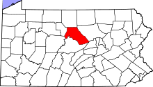 | |
| Boroughs | ||
| Townships | ||
| CDPs | ||
| Unincorporated communities | ||
| Footnotes | ‡This populated place also has portions in an adjacent county | |
This article is issued from
Wikipedia.
The text is licensed under Creative Commons - Attribution - Sharealike.
Additional terms may apply for the media files.