Lamar, Pennsylvania
| Lamar, Pennsylvania | |
|---|---|
| Census-designated place | |
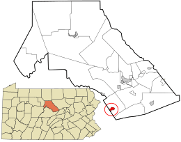 Location in Clinton County and the state of Pennsylvania. | |
| Coordinates: 41°00′54″N 77°31′50″W / 41.01500°N 77.53056°WCoordinates: 41°00′54″N 77°31′50″W / 41.01500°N 77.53056°W | |
| Country | United States |
| State | Pennsylvania |
| County | Clinton |
| Township | Porter |
| Area | |
| • Total | 1.13 sq mi (2.92 km2) |
| • Land | 1.12 sq mi (2.89 km2) |
| • Water | 0.01 sq mi (0.03 km2) |
| Elevation | 795 ft (242 m) |
| Population (2010) | |
| • Total | 562 |
| • Density | 504/sq mi (194.7/km2) |
| Time zone | UTC-5 (Eastern (EST)) |
| • Summer (DST) | UTC-4 (EDT) |
| ZIP code | 16848 |
| FIPS code | 42-41104 |
| GNIS feature ID | 2634235 |
Lamar is a census-designated place[1] in Porter Township in southern Clinton County, Pennsylvania, United States. As of the 2010 census the population was 562.[2]
The community is located along Pennsylvania Route 64 in southern Clinton County and is bordered on the west by Nittany in Walker Township, Centre County. PA 64 leads northeast 1 mile (2 km) to Exit 173 on Interstate 80 and 11 miles (18 km) to Lock Haven, the Clinton County seat, and southwest through Nittany 23 miles (37 km) to State College.
References
- ↑ "Archived copy". Archived from the original on 2013-12-21. Retrieved 2016-09-02.
- ↑ "Geographic Identifiers: 2010 Census Summary File 1 (G001): Lamar CDP, Pennsylvania". U.S. Census Bureau, American Factfinder. Retrieved May 19, 2015.
External links
Municipalities and communities of Clinton County, Pennsylvania, United States | ||
|---|---|---|
| City | 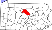 | |
| Boroughs | ||
| Townships | ||
| CDPs | ||
| Unincorporated communities | ||
| Footnotes | ‡This populated place also has portions in an adjacent county | |
This article is issued from
Wikipedia.
The text is licensed under Creative Commons - Attribution - Sharealike.
Additional terms may apply for the media files.