Turramurra
| Turramurra Sydney, New South Wales | |||||||||||||||
|---|---|---|---|---|---|---|---|---|---|---|---|---|---|---|---|
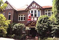
Hillview_guesthouse_Turramurra-2.jpg) Hillview guesthouse, part of the heritage-listed Hillview estate which later became the Hillview Community Health Centre | |||||||||||||||
| Population | 11,919 (2016 census)[1] | ||||||||||||||
| • Density | 1,944.4/km2 (5,036/sq mi) | ||||||||||||||
| Established | 1822 | ||||||||||||||
| Postcode(s) | 2074 | ||||||||||||||
| Area | 6.13 km2 (2.4 sq mi) | ||||||||||||||
| Location | 17 km (11 mi) north of Sydney | ||||||||||||||
| LGA(s) | Ku-ring-gai Council | ||||||||||||||
| State electorate(s) | Ku-ring-gai, Davidson | ||||||||||||||
| Federal Division(s) | Bradfield | ||||||||||||||
| |||||||||||||||
Turramurra_Library-2.jpg)
Turramurra is a suburb on the Upper North Shore of Sydney, in the state of New South Wales, Australia. It is located 17 kilometres (11 mi) north-west of the Sydney central business district, in the local government area of Ku-ring-gai Council. It shares the postcode of 2074 with the adjacent suburbs of North Turramurra, South Turramurra and Warrawee.
History
Turramurra is an Aboriginal word which is thought to mean either high hill, big hill, high place,[2] or small watercourse.[3] The Aboriginal reference of high hill covered the range from Pymble to Turramurra.[4] Early European settlers referred to the area as Eastern Road.
The name Turramurra was adopted when the railway station was built in 1890.
One of the early local landmarks was Ingleholme, a two-storey Federation Queen Anne home in Boomerang Street. It was designed by John Sulman (1849–1934) as his own home and built c. 1896. The house was part of the Presbyterian Ladies College (now the Pymble Ladies' College) until 1977 and was added to the New South Wales State Heritage Register on 2 April 1999;[5] and is on the (now defunct) Register of the National Estate as a notable example of Sulman's style.[6]
Turramurra Post Office opened on 16 August 1890.[7]
St Andrew's in Kissing Point Road is an example of the Federation Carpenter Gothic style. In 1932, Lewy Pattinson, founder of Washington H. Soul Pattinson, gave the Presbyterian Church in NSW the land for Mission Hall, at what is now 106 Kissing Point Road.[4] In 1936, ownership was transferred by Pattinson to St Margaret's Presbyterian Church, Turramurra.[8]
A Turramurra East Post Office opened on 1 May 1959 and closed in 1993. The Turramurra North Post Office opened on 1 September 1953.[7]
North Turramurra[9] and South Turramurra[10] became separate suburbs on 5 August 1994.
Hillview
The Hillview estate, situated on the Pacific Highway, started circa 1890 with a modest Federation cottage facing the highway. Later, the owner realized the commercial potential of the site, with its sweeping views, and built a grand, two-storey Federation home at the rear, to be used as a guesthouse, circa 1913. A large, six-car garage with a dwelling above it was added at the western end of the site in 1915. The estate was later leased out to Ku Ring Gai Hospital, Hornsby, to be used as the Hillview Community Health Centre. The entire estate is heritage-listed.[11]
Heritage listings
Turramurra has a number of heritage-listed sites, including:
- 17 Boomerang Street: Ingleholme[5]
- 43 Ku-Ring-Gai Avenue: Cossington (Turramurra)[12]
Churches
- Sydney Sungrak Baptist Church
- St James Turramurra
- Turramurra Uniting Church
- Uniting Church in Australia
Transport
The Pacific Highway (A1) is a major arterial road in Turramurra. Turramurra railway station is on the North Shore, Northern & Western Line of the Sydney Trains network. Transdev NSW buses run services from the railway station to local residential areas and schools.
Commercial area
The largest commercial area in Turramurra is located along the Pacific Highway and Rohini Street, beside Turramurra railway station. This shopping precinct includes real-estate agents, fruit-markets, banks, bakeries, a musical instrument store, petrol station, Turramurra Arcade. There are two supermarkets in this vicinity. There is Turramurra Plaza with shops, such as shoe-repairs, a fruit shop and a newsagent. A Coles supermarket is located behind Turramurra Station, on Ray Street, near the public library. Turramurra Masonic Centre is located along the Pacific Highway.
Princes Street shops are located in East Turramurra, on the corner of Princes Street and Bannockburn Road, near to Pymble Public School. Princes Street shops include a fine wine store, veterinary hospital, gift shop, delicatessen, butcher and grocer. Street renovations were completed in late 2013 and opened by Ku Ring Gai Mayor Jennifer Anderson during the annual community fair.
There are shops at South Turramurra on Kissing Point Road including a hairdresser, IAG supermarket, cafe, pizza restaurant, chemist, bakery, post office, BP petrol station and other services.
There is also a shopping village in North Turramurra on Bobbin Head Road which has an IGA supermarket, bakery, post office, newsagent and other facilities.
There is also shops along Eastern Road (between 95-105 Eastern Road) which has an IGA supermarket, dry cleaners, BWS liquor, bakery, butchers, greengrocer, pharmacy, florist and independent petrol station. There is a proposal currently underway for a Harris Farm market to be constructed at 105 Eastern Road (the site of GDR automotives) and part of the adjoining nursery. A proposal to rezone and develop an Aldi supermarket was rejected in 2016.[13]
Cherrywood_Turramurra-1.jpg)
Geography
Turramurra is a hilly suburb approximately 170 metres above sea level. On the south-eastern boundary, bordering with Pymble is Sheldon Forest, which has some of the best preserved examples of blue gums and turpentine high forest.
North Turramurra is a separate suburb, north of Burns Road. Bobbin Head Road runs in a north-south direction through North Turramurra and then into the Ku-ring-gai National Park. The North Turramurra shops are located next to North Turramurra Public School. Further north are Ku-ring-gai Chase National Park and Ku-ring-gai Creative Arts High School.
South Turramurra is a separate suburb, south of the Comenarra Parkway and centred on Kissing Point Road. South Turramurra is bordered by Lane Cove National Park start of the Great North Walk. Turramurra High School is in South Turramurra.
East Turramurra is an unofficial urban locality of Turramurra. It is situated in the area of Turramurra east of Bobbin Head Road. It has a small shopping area called Princes Street shops.
Weather
According to the Bureau of Meteorology, Turramurra was the wettest suburb in Sydney in the years 2007,[15] 2008,[16] 2010,[17] 2011,[18] 2012[19] and 2014.[20]
Education
- Turramurra High School (South Turramurra)
- Turramurra Public School
- Warrawee Public School
Sport and recreation
Ku-ring-gai Council has several sporting fields in the area, including a large tennis and netball facility at the end of Canoon Road and Kent Oval which has children's play equipment and tennis courts. Tennis courts and a basketball court are located at Hamilton Park. Irish Town Grove is a park located behind Princes Street shops in East Turramurra. Karuah Oval is a large oval located next to Karuah Road. Turramurra Memorial Park is a large park with an oval, four tennis courts (two grass and two hard), two table tennis tables, a running track, children's play area, outdoor exercise area and public toilets.
Comenarra Park on the Comenarra Parkway has cricket and a soccer field. It also has bushwalking tracks leading into the Lane Cove National Park.
Scouting groups in Turramurra take part in a range of outdoor, social and community service activities. 1st Turramurra Scout Group has active programs for boys and girls aged from 8-11 (Cub Scouts), 11-15 (Scouts) through to young men and women 15-17 (Venturer Scouts) and 18-25 (Rovers).[21][22]
Kissing Point Rover Crew is also based in Turramurra.[23]
Three teams which compete in the Northern Suburbs Football Association (NSFA) association football League have a venue in Turramurra as their home ground: Kissing Point Football Club (KPFC), Wahroonga Tigers Football (WAH) and Bannockburn Rovers (RVS).
The local Kissing Point Cricket Club fields a number of senior and junior sides in the Hornsby, Ku-ring-gai & Hills District Cricket Association. The club was established in 1961.
Residents
Demographics
At the 2016 census, the suburb of Turramurra recorded a population of 11,919 people. Of these:[1]
- Age distribution: The median age was 42 years, compared to the national median of 38 years. Children aged under 15 years made up 20.3% of the population (national average is 18.7%) and people aged 65 years and over made up 18.5% of the population (national average is 15.8%).
- Ethnic diversity : 61.5% of people were born in Australia, compared to the national average of 66.7%; the most common countries of birth were England 6.5%, China 5.1%, South Africa 2.7%, India 2.2% and Korea, South Korea 2.0%. 73.2% of people only spoke English at home. Other languages spoken at home included Mandarin 6.0%, Cantonese 3.4%, Korean 2.3%, Persian 1.1% and Hindi 0.9%
- Religion : The most common responses for religion were No Religion 29.5%, Anglican 20.5% and Catholic 20.3%.
- Finances: The median household weekly income was $2,657, compared to the national median of $1,438. This difference is also reflected in real estate, with the median mortgage payment being $3,000 per month, compared to the national median of $1,755.
- Housing: The great majority (73.9%) of occupied private dwellings were separate houses, 22.0% were flats, units or apartments, and 3.9% were semi-detached. The average household size was 2.9 people.
Notable residents
- Brett Beyer, Olympic sailing coach
- Faith Bandler, Aboriginal activist
- Trevor Allan Canoon Rd Turramurra in a house called Murrayfield named for the ground on which he made his debut as captain for Australian rugby.
- Eric Campbell, Leader of the New Guard lived at Boongala, 28 Ku-ring-gai Avenue[24]
- Grace Cossington Smith 20th-century Australian painter lived in Ku-ring-gai Avenue, Turramurra most of her life
- Shane Gould, gold medallist swimmer at 1972 Summer Olympics (Munich), attended Turramurra High School
- Stuart Inder, journalist, editor and specialist in Pacific Islands affairs[25]
- Kamahl, singer
- Gail Kelly, business woman
- John Kerr, Governor-General of Australia, lived on the corner of Kissing Point Road and Catalpa Crescent for part of his life
- Gretel Killeen, host of Big Brother Australia and author, was born in the suburb and spent some of her childhood at 24 Fairlawn Avenue
- Chris Lilley, actor and comedian (Summer Heights High), grew up there
- Gail Neall gold medallist swimmer at 1972 Summer Olympics (Munich), attended Turramurra High School
- Barry O'Farrell, Premier of New South Wales 2011-14, has lived with his family in Turramurra since 2011 or 2012. As a member of parliament, he has represented the electoral district of Ku-ring-gai, including Turramurra[26][27][28]
- Leslie Alfred Redgrave, author of the 1913 novel Gwen: a romance of Australian station life[29] and proprietor headmaster of Highfield College at 51 Ku-ring-gai Avenue, Turramurra, from 1907 until 1915.[30]
- Frank Riethmuller, German–Australian rose-breeder, boarded for seven years at "Wychwood" in Ku-Ring-Gai Avenue, in 1937 made a house and garden containing many original roses at 21 Eastern Road. Died in 1965
- Tony Roche, former coach of world number-one tennis player, Roger Federer
- Ken Rosewall, tennis great, became a resident in 1960
- Dave Sharma, diplomat, grew up there
- George Szekeres, mathematician
- Barrie Unsworth, Premier of New South Wales 1986–88, lived in Geoffrey Street
- Charles Weston, horticulturalist
- Prof Sir Brian Wellingham Windeyer (1904-1994), born in Turramurra; Professor of Therapeutic Radiology at Middlesex Hospital Medical School, University of London 1942-69; Vice-Chancellor, University of London (1969–72)
References
- 1 2 Australian Bureau of Statistics (27 June 2017). "Turramurra (State Suburb)". 2016 Census QuickStats. Retrieved 12 September 2017.

- ↑ "Turramurra". Kur-ing-gai Historical Society. Retrieved 9 September 2013.
- ↑ McCarthy; 1963, cited in "Turramurra". Geographical Names Register (GNR) of NSW. Geographical Names Board of New South Wales. Retrieved 22 January 2015.
- 1 2 Cook, Kerrin Margaret (1991). The railway came to Ku Ring gai. Genlin Investments. ISBN 064605113X.
- 1 2 "Ingleholme & Garage, New South Wales State Heritage Register (NSW SHR) Number H00071". New South Wales State Heritage Register. Office of Environment and Heritage. Retrieved 18 May 2018.
- ↑ The Heritage of Australia, Macmillan Company, 1981, p.2/33
- 1 2 Premier Postal History. "Post Office List". Premier Postal Auctions. Retrieved 16 June 2012.
- ↑ "St Andrews Uniting Church, S Turramurra / History of St Andrews". pbworks.com.
- ↑ "North Turramurra". Geographical Names Register (GNR) of NSW. Geographical Names Board of New South Wales. Retrieved 22 January 2015.
- ↑ "South Turramurra". Geographical Names Register (GNR) of NSW. Geographical Names Board of New South Wales. Retrieved 22 January 2015.
- ↑ "Hillview Garages & Precincts". nsw.gov.au.
- ↑ "Cossington, New South Wales State Heritage Register (NSW SHR) Number H01763". New South Wales State Heritage Register. Office of Environment and Heritage. Retrieved 18 May 2018.
- ↑ Duval, Vanessa. "Ku-ring-gai Council - State Government rejects Planning Proposal for Aldi supermarket in Turramurra". www.kmc.nsw.gov.au. Retrieved 2018-04-17.
- ↑ "Cherrywood Nursing Home". nsw.gov.au.
- ↑ Bureau of Meteorology. "Extremes in 2007". Commonwealth of Australia. Retrieved 22 January 2015.
- ↑ Bureau of Meteorology. "Extremes in 2008". Commonwealth of Australia. Retrieved 22 January 2015.
- ↑ Bureau of Meteorology. "Extremes in 2010". Commonwealth of Australia. Retrieved 22 January 2015.
- ↑ Bureau of Meteorology. "Extremes in 2011". Commonwealth of Australia. Retrieved 22 January 2015.
- ↑ Bureau of Meteorology. "Extremes in 2012". Commonwealth of Australia. Retrieved 22 January 2015.
- ↑ Bureau of Meteorology. "Extremes in 2014". Commonwealth of Australia. Retrieved 22 January 2015.
- ↑ "1st Turramurra Scout Group".
- ↑ "Sydney North Region - Turramurra Rovers". sydneynorthscouts.com.
- ↑ "Sydney North Region - Kissing Point Rovers". sydneynorthscouts.com.
- ↑ "Biography - Eric Campbell - Australian Dictionary of Biography". anu.edu.au.
- ↑ "Stuart Gerald Inder obituary". Sydney Morning Herald. 2015-02-05. Retrieved 2015-03-01.
- ↑ "Ku-ring-gai - NSW Votes 2011". ABC News. Archived from the original on 18 February 2012.
- ↑ Marr, David (29 August 2009). "Out of the ordinary". Brisbane Times. Fairfax Media. Retrieved 2013-01-11.
- ↑ Nicholls, Sean (24 March 2012). "Out of the ordinary". Sydney Morning Herald. Retrieved 2013-01-11.
- ↑ National Library of Australia Retrieved 30 April 2014
- ↑ "SOCIAL ITEMS". The Evening News. Sydney: National Library of Australia. 26 December 1908. p. 14. Retrieved 30 April 2014.
External links
| Wikimedia Commons has media related to Turramurra, New South Wales. |
- Joan Rowland (2011). "Turramurra". Dictionary of Sydney. Retrieved 29 September 2015. [CC-By-SA]
Coordinates: 33°44′02″S 151°07′48″E / 33.7338°S 151.1301°E