Turner, Phillips County, Arkansas
| Turner, Arkansas | |
|---|---|
| Unincorporated community | |
 Turner, Arkansas Turner's position in Arkansas. | |
| Coordinates: 34°28′34.4″N 91°1′7.4″W / 34.476222°N 91.018722°WCoordinates: 34°28′34.4″N 91°1′7.4″W / 34.476222°N 91.018722°W | |
| Country |
|
| State |
|
| County | Phillips |
| Township | Cypress |
| Elevation | 16 m (53 ft) |
| Time zone | UTC-6 (Central (CST)) |
| • Summer (DST) | UTC-5 (CDT) |
| ZIP Code | 72383 |
| Area code(s) | 870 |
| GNIS feature ID | 58771 |
| U.S. Geological Survey Geographic Names Information System: Turner, Phillips County, Arkansas | |
Turner is an unincorporated community in Cypress Township, Phillips County, Arkansas, United States.[1] The community is located at the intersection of Arkansas Highway 316 and the end of a concurrency between Arkansas Highway 1/Arkansas Highway 39.[2]
See also
References
- ↑ "Feature Detail Report for: Turner, Arkansas." USGS. U.S. Geological Survey Geographic Names Information System: Turner, Phillips County, Arkansas Retrieved April 18, 2011.
- ↑ Arkansas Atlas and Gazetteer (Map) (Second ed.). DeLorme. § 51.
Municipalities and communities of Phillips County, Arkansas, United States | ||
|---|---|---|
| Cities | 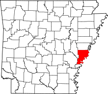 | |
| Town | ||
| Townships |
| |
| Unincorporated communities | ||
This article is issued from
Wikipedia.
The text is licensed under Creative Commons - Attribution - Sharealike.
Additional terms may apply for the media files.