Tuqu'
| Tuqu' | |
|---|---|
| Other transcription(s) | |
| • Arabic | تقوع |
| • Also spelled |
Taqua (official) Teqoa (unofficial) |
 Tuqu' Location of Tuqu' within Palestine | |
| Coordinates: 31°38′11″N 35°12′52″E / 31.63639°N 35.21444°ECoordinates: 31°38′11″N 35°12′52″E / 31.63639°N 35.21444°E | |
| Palestine grid | 170/115 |
| Governorate | Bethlehem |
| Government | |
| • Type | Municipality (from 1997) |
| • Head of Municipality | Khaled Ahmad Hamida |
| Area (built-up) | |
| • Jurisdiction | 590 dunams (0.6 km2 or 0.2 sq mi) |
| Population (2007) | |
| • Jurisdiction | 8,881 |
| Name meaning | "The ruin of Tekua",[1] or "the place for pitching tents" |
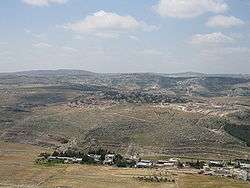
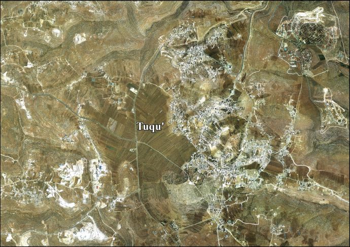
Tuquʿ (Arabic: تقوع, also spelled Teqoa) is a Palestinian town in the Bethlehem Governorate, located 12 km southeast of Bethlehem in the West Bank. The town is built adjacent to the biblical site of Tekoa (Thecoe), from which it takes its name. Today's town includes three other localities: Khirbet Ad Deir, Al Halkoom, and Khirbet Tuqu’.[2] According to the Palestinian Central Bureau of Statistics (PCBS), Tuqu' had a population of 8,881 in 2007.[3]
The town is a part of the 'Arab al-Ta'amira village cluster, along with Za'atara, Beit Ta'mir, Hindaza, Khirbet al-Deir and al-Asakra. Tuqu has a municipal jurisdiction of over 191,262 dunams, but its built-up area consists of 590 dunams,[2] as 98.5% of the village's land is classified by Israel as Area C or Nature Reserves, and 1.5% as Area B.[4] Situated in the immediate vicinity is the modern Israeli settlement of Tekoa.
Etymology
Strong's Concordance states that Tekoa means "a stockade".[5] Gesenius' lexicon uses "the pitching" in reference to tents.[6]
Location
Tuqu’ is located 12km (horizontal distance) south-east of Bethlehem. It is bordered by Tuqu’ wilds to the east, Jannatah town to the north, Al Manshiya and Marah Rabah to the west, and Al Maniya and Kisan villages to the south.[7]
In the Hebrew Bible
According to biblical sources, Ephrathites from Bethlehem and the Calebites from Hebron founded Tuqu' (Tekoa). In the Jewish Encyclopedia (1901), Isidore Singer notes that "the Greek text of a passage (Joshua 15:60) lost in the Hebrew places it, together with Bethlehem and other towns of the hill-country of Judah, south of Jerusalem".[8] The land was described as a "desert" in 2 Chronicles 20:20, but Amos 1:1 describes the prophet as "a herdsman of Tekoa", suggesting that the land was reasonable for shepherding.
History
Tekoa, the town known from the Hebrew Bible and other classical ancient sources, has been identified with Khirbet Tekua ("ruins of Tekua"), c. 5 miles (8 km) south of Bethlehem,[10] also spelled Khirbet al-Tuq'u.[11]
Hellenistic period
During the Maccabean Revolt it was fortified by the Greek general Bacchides (Josephus, Ant. XIII, 15).[10]
Roman period
Josephus again mentions Tekoa in connection with the First Jewish–Roman War (Life 420, War IV, 518).[10] Eusebius (c. 260s-340) mentions a village by the name of Tekoa (Onomasticon 98:17, etc.).[10]
Byzantine period
Tekoa is again mentioned in Byzantine sources.[10]
Muslim conquest and Early Muslim period
Tekoa was captured by the Arab Muslim army during the Muslim conquest of Syria and with time, several of its inhabitants converted to Islam. There was a significant nomadic Bedouin presence in the village's vicinity.[11]
Crusader and Ayyubid period
Teqo'a was known as "Casal Techue" by the Crusaders who conquered Palestine in 1099. Its Christian residents welcomed the Crusaders.[11] Medieval chronicler William of Tyre relates that the Christians of the village aided the Crusaders during the Siege of Jerusalem in 1099, by guiding them to local springs and food sources. Many of the villagers also joined the Crusader army.[12]
In 1108, the Russian traveller Abbot Daniel noted that Casal Techue was "a very big village" with a mixed Christian and Muslim population.[11] The village was granted by King Fulk and Queen Melisende to the canons of the Holy Sepulchre in 1138 in exchange for Bethany, the concession allowing the inhabitants to collect bitumen and 'salt' from the Dead Sea shores.[13][11] The area's population included villeins comprising local Christians and Muslims, the latter being Islamised former Christians, and apparently also recent Frankish (West European) settlers, with Bedouin living outside the village.[11]
The ruins of a castle, a Frankish manor house[11] from the period, are found at Khirbat at-Tuqu' at the edge of the biblical and Byzantine archaeological mound, some 41x48x60x60 m in size, and protected by a rock-cut ditch.[13][14]
Zengid forces captured Casal Techue in 1138. The Knights Templar under Robert the Burgundian managed to recapture the town easily, but experienced their first military defeat when Zengid forces counterattacked, leaving the area between the town and Hebron "strewn with Templar bodies" according to William of Tyre. He blamed the Templars' defeat on their failure to pursue fleeing Muslim forces which allowed them to regroup just outside Casal Techue.[15]
Syrian geographer Yaqut al-Hamawi described it as "a village famous for its honey" during a visit there in 1225,[13][16] during Ayyubid rule.
Ottoman period
Tuqu', like all of Palestine, was incorporated into the Ottoman Empire in 1517. According to an Ottoman census in 1526, 82 families lived in the village, 55 of which were Christians.[11] In 1596 the village appeared in Ottoman tax registers as being in the Nahiya of Quds of the Liwa of Quds. It had a population of 62 Muslim households and five Christian households. It paid taxes on wheat, barley, olives, vines or fruit trees, and goats or beehives.[17]
The majority of Tuqu's Christian inhabitants emigrated to Bethlehem in the 18th century.[18] Tuqu's Christian emigrants formed Bethlehem's Qawawsa Quarter.[19]
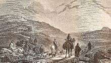
French explorer Victor Guérin visited the place in 1863, and he described finding the scarce remains of a church, and an octagonal baptismal font.[20]
The Palestine Exploration Fund's Survey of Western Palestine in 1883 mentions that Khurbet Tequa "seems to have been large and important in Christian times. It is still inhabited by a few persons living in the caves [...]"[21]
In the eighteenth century the Christian inhabitants of the village migrated to Bethlehem.[18]
Jordanian period
The modern town of Tuqu' was established in 1948 during Jordanian rule.[2][22] The inhabitants were Bedouin tribesmen from the 'Arab al-Ta'amira tribe.[2][22] In 1961, the population was 555.[23]
Post-1967 period
Since the Six-Day War in 1967, Tuqu' has been under Israeli occupation. The population in the 1967 census conducted by the Israeli authorities was 1,362.[24]
Over the years, Israel has illegally confiscated 1436 dunams of Tuqu's land for the construction of three Israeli settlements: Tekoa, Mitzpe Shalem, and a resort, Metzoke Dragot. In addition, the settlers have constructed various outposts.[25]
In May 2001, after the killing of two Jewish Israeli boys outside the nearby Israeli settlement of Tekoa, Tuqu' was temporarily sealed off by the Israeli Army. Consequently, residents could not reach their jobs in Bethlehem and Israel, and shepherds could not reach grazing lands outside the village.[26]
Archaeology and landmarks

Khirbet Tuqu', located about two kilometers east of modern Tuqu',[18] is the archaeological site identified with ancient Tekoa.[13] The site is considered "qualified in terms of tourism".[2] A second archaeological site near Tuqu', Khirbet Umm El 'Amd, is "not qualified" in terms of tourism.[2]
Various ruins were seen at the site in the mid-19th century. These included the walls of houses, cisterns, broken columns and heaps of building stones, some of which had "bevelled edges" which supposedly indicated ancient Jewish origin.[27]
Byzantine-period remnants
The Bible indicates Tekoa (now Khirbet Tuqu') as the birthplace of prophet Amos, and from the 4th century CE on a tomb alleged to be his was said to be visible at the village.[13] A chapel built over the tomb is attested in the 6th century and is mentioned again in the 8th.[13] The ruins consist of a double cave over what was a baptismal font, mosaic floors; a Monophysite monastery is located near the tomb.[18] Byzantine ceramics have been found.[28] The remains of the Byzantine church and monastery are still visible.[18][19]
When Victor Guérin visited the site in 1863, he described the remains of an almost completely destroyed church, and an octagonal baptismal font, carved into a monolithic block of reddish limestone, measuring a meter and ten centimeters deep inside, and one meter thirty centimeters in diameter. On different sides of the octagon crosses were carved. At the bottom of the baptismal font the water flowed through an opening into a tank.[20] The Survey of Western Palestine, with data collected between 1872–1877, refers again to the font: "There is also a very fine octagonal font about 4 feet high and 4 feet 3 inches diameter of inscribed circle; on every other side is a design. Two of these designs represent crosses, a third is a wreath, the fourth is formed by two squares interlaced diagonally to one another. The font is of good reddish stone."[21]
Paleolithic caves in Wadi Khureitun
Outside Tuqu', adjacent to the Israeli settlement of Tekoa is Wadi Khureitun[13], sometimes spelled Khreiton ("Chariton Valley"). The valley is notable for containing three prominent caves inhabited since the Paleolithic era: Umm Qatfa, Umm Qala'a and Erq al-Ahmar. The latter was inhabited since 8,000 BCE and traces of fire have been found in Umm Qala'a, dating back 500,000 years.[29]
Demographics
According to a 1997 census by the Palestinian Central Bureau of Statistics (PCBS), Tuqu' had a population of 4,890 inhabitants. There were only 24 Palestinian refugees, making up 0.5% of the population.[30] There were 2,534 males and 2,356 females.[31] Tuqu's population grew to 8,881 in the 2007 PCBS census. There were 1,368 households, with the average household size consisting of between six and seven members. The gender ratio was 49% women and 51% men.[3]
Tuqu' currently has a Muslim majority and there are ten mosques in the town. They are the following: Abu Bakr as-Siddik Mosque, Bilal Ibn Rabah Mosque, al-Sahaba Mosque, al-Tawba Mosque, Abd al-Rahman Ibn 'Oof Mosque, Zaid Ibn Haritha Mosque, al-Abbas Mosque and Salah ad-Deen Mosque, al-Ansar Mosque and Ali Ibn Abi Talib Mosque. Most of the inhabitants belong to the 'Arab al-Ta'amira tribe. Principal clans include Badan, Jibreen, Sha'er, 'Emur, Nawawra, 'Urooj, Abu Mifrih, az-Zawahra, Sbeih, at-Tnooh, Sleiman and Sabbah.[2]
The Tuqu´population initially comprised 80% Christians and 20% Jews until year 700 when many of its inhabitants converted to Islam.
Economy
Agriculture, particularly livestock, dominates Tuqu's economy. Dairy is produced and sold in local markets and in Bethlehem. Industry is virtually nonexistent, although there is a stone quarry and brick factory in the town. Unemployment is high at about 50% and mostly caused by Israeli restrictions on movement and access to the labor market in Israel proper as a result of the Second Intifada between 2000-04.[2]
As of 2008 around 45% of Tuqu's workforce was employed in the Israeli labor market while another 30% worked in agriculture. The remainder of economic activity was split between employment in the Palestinian government or trade and services.[2] Efforts have been made to attract tourists. A municipal center was built near the ruins of a Byzantine church in Tuqu'.[26] Tuqu' is well known for its vegetables.[18]
Government
98,5% Tuqu' has been located in Area C (West Bank), or Nature reserves since 1995, thus giving the Palestinian National Authority no control over its administration and civil affairs. Originally, twelve tribal elders managed the town, but unable to plan and carry out internal improvements, they ceded their power to a council of younger men.[32] The 13-member municipal council was established in 1997 to administer Tuqu' as well as the villages of Khirbet al-Deir, al-Halqum and Khirbet Tuqu' which were put under Tuqu's jurisdiction.[2] Its first mayor, Suleiman Abu Mufarreh, initiated the construction of the municipal hall and recovered Tuqu's stolen baptismal font, relocating it to the front of the municipal hall.[32]
Tuqu' is governed by a municipal council consisting of eleven members, including the mayor. In the 2005 Palestinian municipal elections, the Hamas-backed Reform list won the majority of the seats (eight), while the independent local United Tuqu' list won three. Reform member Khaled Ahmad Hamida won the post of mayor, succeeding Raed Hamida.[33]
References
- ↑ Palmer, 1881, p. 402
- 1 2 3 4 5 6 7 8 9 10 Tuqu' Town Profile, Applied Research Institute-Jerusalem, 2008. Retrieved on 2012-03-13.
- 1 2 2007 PCBS Census Archived December 10, 2010, at the Wayback Machine. Palestinian Central Bureau of Statistics. p. 117
- ↑ '15 Palestinians detained in Tuqu near Bethlehem', Ma'an News Agency 19 March 2015.
- ↑ Lexicon :: Strong's H8620 - Tĕqowa`, accessed 7 August 2018
- ↑ Gesenius' Hebrew-Chaldee Lexicon s.v. תְּקוֹעַ
- ↑ Tuqu’ Town Profile, ARIJ, p. 4
- ↑ Singer, I., The 1901 Jewish Encyclopedia - Tekoa, accessed 25 July 2017
- ↑ Thomson, 1859, p. 425
- 1 2 3 4 5 Negev, Avraham; Gibson, Shimon (2001). xxx. Archaeological Encyclopedia of the Holy Land. New York and London: Continuum. p. 496. ISBN 0-8264-1316-1.
- 1 2 3 4 5 6 7 8 Ellenblum, 2003, p. 136-137
- ↑ Thekoa - (Tuqu'a) Studium Biblicum Franciscanum - Jerusalem.
- 1 2 3 4 5 6 7 Pringle, 1998, pp. 347-348
- ↑ Pringle, Denys (2009). Tuqu', Khirbat at- (No. 226). Secular Buildings in the Crusader Kingdom of Jerusalem: An Archaeological Gazetteer. Cambridge University Press. p. 103. ISBN 9780521102636. Retrieved 4 September 2018.
- ↑ Howarth, Stephen. (1991). The Knights Templar Barnes & Noble Publishing, p.97.
- ↑ Le Strange, Guy, Palestine under the Moslems, p. 542, London, 1890
- ↑ Hütteroth and Abdulfattah, 1977, p. 114
- 1 2 3 4 5 6 Taqou' village (1998) Mitri Raheb and Fred Strickert, Bethlehem 2000: Past and Present, Palmyra publishing house, 1998, via This Week in Palestine
- 1 2 Tqoa’ area Zeiter, Leila. Centre for Preservation of Culture and History.
- 1 2 Guérin, 1869, p. 141
- 1 2 Conder and Kitchener, 1883, SWP III, p. 368
- 1 2 Kark, Ruth; Oren-Nordheim, Michal (2001). Jerusalem and its environs : quarters, neighborhoods, villages, 1800-1948. Detroit, Jerusalem: Wayne State University Press; Hebrew Univ. Magnes Press [u.a.] pp. 202, 241, 279ff. ISBN 978-0814329092. Retrieved 12 October 2015.
- ↑ Government of Jordan, Department of Statistics, 1964, p. 23
- ↑ Perlmann, Joel (November 2011 – February 2012). "The 1967 Census of the West Bank and Gaza Strip: A Digitized Version" (PDF). Levy Economics Institute. Retrieved 24 June 2016.
- ↑ Tuqu' Town (Fact Sheet), ARIJ, pp. 17-18,
- 1 2 Prophet Amos's Words Still Ring True Archived 2008-10-25 at the Wayback Machine. Abu Ghazaleh, Sami. International Center of Bethlehem
- ↑ William Aldis Wright; et al. (1865). Sir William Smith, ed. A concise dictionary of the Bible for the use of families and students. London: John Murray. p. 924. Retrieved 4 September 2018.
- ↑ Dauphin, 1998, p. 928
- ↑ Wadi Khreitoun Zeitar, Leila. Centre for Cultural Heritage Preservation.
- ↑ Palestinian Population by Locality and Refugee Status Archived 2008-11-18 at the Wayback Machine. (1997) Palestinian Central Bureau of Statistics (PCBS)
- ↑ Palestinian Population by Locality, Sex and Age Groups in Years Archived 2012-01-11 at the Wayback Machine. (1997) Palestinian Central Bureau of Statistics (PCBS)
- 1 2 Levin, Jerry. Save our heritage in the Holy Land Al-Ahram Weekly. October 2003.
- ↑ Local Elections (Round two)- Successful candidates by local authority, gender and No. of votes obtained Archived 2007-06-30 at the Wayback Machine. Central Elections Commission - Palestine, p.25
Bibliography
- Conder, C.R.; Kitchener, H. H. (1883). The Survey of Western Palestine: Memoirs of the Topography, Orography, Hydrography, and Archaeology. 3. London: Committee of the Palestine Exploration Fund.
- Dauphin, Claudine (1998). La Palestine byzantine, Peuplement et Populations. BAR International Series 726 (in French). III : Catalogue. Oxford: Archeopress. ISBN 0-860549-05-4.
- Ellenblum, Ronnie (2003). Frankish Rural Settlement in the Latin Kingdom of Jerusalem. Cambridge University Press. ISBN 0521521874.
- Government of Jordan, Department of Statistics (1964). First Census of Population and Housing. Volume I: Final Tables; General Characteristics of the Population (PDF).
- Guérin, V. (1869). Description Géographique Historique et Archéologique de la Palestine (in French). 1: Judee, pt. 3. Paris: L'Imprimerie Nationale.
- Hütteroth, Wolf-Dieter; Abdulfattah, Kamal (1977). Historical Geography of Palestine, Transjordan and Southern Syria in the Late 16th Century. Erlanger Geographische Arbeiten, Sonderband 5. Erlangen, Germany: Vorstand der Fränkischen Geographischen Gesellschaft. ISBN 3-920405-41-2.
- Palmer, E. H. (1881). The Survey of Western Palestine: Arabic and English Name Lists Collected During the Survey by Lieutenants Conder and Kitchener, R. E. Transliterated and Explained by E.H. Palmer. Committee of the Palestine Exploration Fund.
- Pringle, Denys (1998). The Churches of the Crusader Kingdom of Jerusalem: L-Z (excluding Tyre). II. Cambridge University Press. ISBN 0 521 39037 0.
- Robinson, E.; Smith, E. (1841). Biblical Researches in Palestine, Mount Sinai and Arabia Petraea: A Journal of Travels in the year 1838. 2. Boston: Crocker & Brewster. (pp. 183 ff, Tekoa)
- Röhricht, R. (1893). (RRH) Regesta regni Hierosolymitani (MXCVII-MCCXCI) (in Latin). Berlin: Libraria Academica Wageriana. (pp. 43-44, no. 174)
- Strange, le, G. (1890). Palestine Under the Moslems: A Description of Syria and the Holy Land from A.D. 650 to 1500. Committee of the Palestine Exploration Fund.
- Thomson, W.M. (1859). The Land and the Book: Or, Biblical Illustrations Drawn from the Manners and Customs, the Scenes and Scenery, of the Holy Land. 2 (1 ed.). New York: Harper & brothers.
External links
- Welcome To Taqu'
- Tekoa, Welcome to Palestine
- Survey of Western Palestine, Map 21: IAA, Wikimedia commons
- Tuqu' Town (Fact Sheet), Applied Research Institute–Jerusalem (ARIJ)
- Tuqu’ Town Profile, ARIJ
- Tuqu’ aerial photo, ARIJ
| Cities |  | |
|---|---|---|
| Municipalities | ||
| Villages |
| |
| Refugee camps | ||
| Other | ||