Tshopo
| Tshopo Province | |
|---|---|
| Province | |
_-_Tshopo.svg.png) | |
| Coordinates: 0°31′N 25°12′E / 0.517°N 25.200°ECoordinates: 0°31′N 25°12′E / 0.517°N 25.200°E | |
| Country |
|
| Capital | Kisangani |
| Government | |
| • Governor | Constant Lomata Kongoli[1] |
| Area | |
| • Total | 199,567 km2 (77,053 sq mi) |
| Population (2005 est.) | |
| • Total | 2,614,630 |
| • Density | 13/km2 (34/sq mi) |
| Official language | French |
Tshopo is one of the 26 provinces of the Democratic Republic of the Congo.[2] It is situated in the northeast of the country on the Tshopo River, for which it is named. Its capital is Kisangani.
Territories
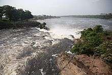
Cascades of the Tshopo River
The provincial capital is the city of Kisangani. Territories are:[3]
History
From 1963 to 1966, the area was constituted as the province of Haut-Congo. It was merged into Orientale Province in 1966 as, separately, the District of Tshopo and the city of Kisangani. The Presidents (later governors) of Haut-Congo were:
- 1963 – 26 June 1963: Georges Grenfell (b. 1908)
- 26 June 1963 – 1964: Paul Isombuma
- 1964 – August 1964: François Aradjabu
- August 1964 – 5 Nov 1966: Jean Marie Alamazani
Provincial status was re-instated to Tshopo in 2015, being formed from Tshopo District and the city of Kisangani.[4]
Approximate correspondence between historical and current province
| Belgian Congo | Republic of the Congo | Zaire | Democratic Republic of the Congo | ||||||
|---|---|---|---|---|---|---|---|---|---|
| 1908 | 1919 | 1932 | 1947 | 1963 | 1966 | 1971 | 1988 | 1997 | 2015 |
| 22 districts | 4 provinces | 6 provinces | 6 provinces | 21 provinces + capital | 8 provinces + capital | 8 provinces + capital | 11 provinces | 11 provinces | 26 provinces |
| Bas-Uele | Orientale | Stanleyville | Orientale | Uele | Orientale | Haut-Zaïre | Orientale | Bas-Uele | |
| Haut-Uele | Haut-Uele | ||||||||
| Ituri | Kibali-Ituri | Ituri | |||||||
| Stanleyville | Haut-Congo | Tshopo | |||||||
| Aruwimi | |||||||||
| Maniema | Costermansville | Kivu | Maniema | Kivu | Maniema | ||||
| Lowa | |||||||||
| Kivu | Nord-Kivu | Nord-Kivu | |||||||
| Kivu-Central | Sud-Kivu | ||||||||
References
- ↑ "Remise et reprise au Gouvernorat de la province de la Tshopo". mediacongo.net. 10 October 2017. Retrieved 16 October 2017.
- ↑ Central Intelligence Agency (2016). "Democratic Republic of the Congo". The World Factbook. Langley, Virginia: Central Intelligence Agency. Retrieved 10 May 2016.
- ↑ Blaes, X. (October 2008). "Découpage administratif de la République Démocratique du Congo" (PDF). PNUD-SIG. Archived from the original (PDF) on 2010-04-01. Retrieved 2011-12-09.
- ↑ "Provinces of the Democratic Republic of Congo". Statiods.com.
External links
- Provinceorientale.cd the Government official site for Orientale Province.
- Stanleyville.be City of Kisangani Website.
- Bamanisajean.unblog.fr is Governor Jean Bamanisa's blog site.
- @Prov_orientale Twitter for Orentale Provincial Government
- Facebook Orentale Provincial Government
This article is issued from
Wikipedia.
The text is licensed under Creative Commons - Attribution - Sharealike.
Additional terms may apply for the media files.