Kivu
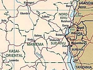
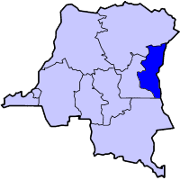
Kivu was the name for a large "Region" in the Democratic Republic of Congo under the rule of Mobutu Sese Seko that bordered Lake Kivu. It included three "Sub-Regions" ("Sous-Regions" in French): Nord-Kivu, Sud-Kivu and Maniema, corresponding to the three current provinces created in 1986.[1] The capital of the Kivu Region was in Bukavu, and the capitals of the three Sub-Regions were in Goma, Uvira and Kindu.
Geography
Kivu is also the name for the entire region surrounding Lake Kivu, including the portions in Rwanda which contain the vast majority of the lake area's population (the contiguous towns of Goma, Democratic Republic of Congo and Gisenyi, Rwanda, with a combined population approaching 1,000,000, form the largest urbanised area in the Lake Kivu area).[2] The area is characterized by lush vegetation and an extended growing season due in part to its high altitude (1500 m or 4900 ft at the lakeshore) and the volcanic nature of its soil. The Kivu region represents the high point of the East African Rift Valley.
The lake itself contains a massive amount of carbon dioxide in its depths, and there is some concern that tectonic activity (rifting) and/or volcanic activity might cause a sudden release of this captured carbon dioxide. If this were to happen it would devastate the population around the lake; however, the likelihood of this occurring is in dispute with arguments on both sides.
Approximate correspondence between historical and current provinces
| Belgian Congo | Republic of the Congo | Zaire | Democratic Republic of the Congo | ||||||
|---|---|---|---|---|---|---|---|---|---|
| 1908 | 1919 | 1932 | 1947 | 1963 | 1966 | 1971 | 1988 | 1997 | 2015 |
| 22 districts | 4 provinces | 6 provinces | 6 provinces | 21 provinces + capital | 8 provinces + capital | 8 provinces + capital | 11 provinces | 11 provinces | 26 provinces |
| Bas-Uele | Orientale | Stanleyville | Orientale | Uele | Orientale | Haut-Zaïre | Orientale | Bas-Uele | |
| Haut-Uele | Haut-Uele | ||||||||
| Ituri | Kibali-Ituri | Ituri | |||||||
| Stanleyville | Haut-Congo | Tshopo | |||||||
| Aruwimi | |||||||||
| Maniema | Costermansville | Kivu | Maniema | Kivu | Maniema | ||||
| Lowa | |||||||||
| Kivu | Nord-Kivu | Nord-Kivu | |||||||
| Kivu-Central | Sud-Kivu | ||||||||
References
- ↑ International Crisis Group, Congo: A Comprehensive Strategy to Disarm the FDLR, Africa Report No. 151, 9 July 2009, p. 1
- ↑ Lake Kivu Home Page