Kongo Central
| Kongo Central Province Province du Kongo Central | |
|---|---|
| Province | |
_-_Bas-Congo.svg.png) | |
| Coordinates: 05°49′S 13°29′E / 5.817°S 13.483°ECoordinates: 05°49′S 13°29′E / 5.817°S 13.483°E | |
| Country |
|
| Capital | Matadi |
| Largest city | Matadi |
| Government | |
| • Governor | Jacques Mbadu Nsitu Di Mavungu |
| Area | |
| • Total | 53,920 km2 (20,820 sq mi) |
| Population (2010 est.) | |
| • Total | 4,522,942 |
| • Density | 84/km2 (220/sq mi) |
| Demonym(s) | Bakongo |
| Official language | French |
| National language | Kikongo |
| Website | kongocentral.net |
Kongo Central, formerly Bas-Congo, is one of the 26 provinces of the Democratic Republic of the Congo.[1] Its capital is Matadi.
History
At the time of independence, the area now encompassing Kongo Central was part of the greater province of Leopoldville, along with the city of Kinshasa and the districts of Kwango, Kwilu and Mai-Ndombe. Under Belgian colonial rule, the province was known as Bas-Congo (as in "Lower Congo River") and was renamed Kongo Central after independence[2][3] Under the Mobutu regime when the Congo river was renamed "Zaire", it became Bas-Zaïre and then reverted to Bas-Congo. It was subsequently renamed Kongo Central in 2015.
Geography
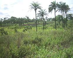
Kongo Central is the only province with a coastline (Atlantic Ocean). It borders the provinces of Kinshasa to the north-east, Kwango to the east, and the Republic of Angola to the south as well as the Republic of the Congo and Cabinda to the north.
Divisions
The provincial capital is Matadi. The only other official city is Boma. The remainder of the province is divided into the districts of Bas-Fleuve, Cataractes and Lukaya. Towns with their 2010 populations are:
References
- ↑ Central Intelligence Agency (2016). "Democratic Republic of the Congo". The World Factbook. Langley, Virginia: Central Intelligence Agency. Retrieved 10 May 2016.
- ↑ "Constitution de la République Démocratique du Congo du 1er août 1964" [Constitution of the Democratic Republic of the Congo of 1 August 1964]. Global Legal Information Network (in French). 1964. Archived from the original on 2 August 2012. Retrieved 22 May 2012. (Article 4)
- ↑ "Constitution de la République Démocratique du Congo du 24 juin 1967" [Constitution of the Democratic Republic of the Congo of 24 June 1967]. Global Legal Information Network (in French). 1967. Archived from the original on 2 August 2012. Retrieved 22 May 2012. (Article 1)
- 1 2 "Bas-Congo: largest cities and towns and statistics of their population". World Gazetteer. Archived from the original on 2012-12-16.
Bibliography
| Wikimedia Commons has media related to Kongo Central. |
- Gillet, J. (1927) Catalogue des plantes du jardin d'essais de la mission de Kisantu. Bruxelles 166 pp.
- Pauwels, L. (1993) Nzayilu N'ti – guide des arbres et arbustes de la région de Kinshasa – Brazzaville. Meise ISBN 9072619102, 495 pp.
- Latham, P. (2003) Edible caterpillars and their food plants in Bas-Congo Mystole Publications. ISBN 0954301277, 60 pp.
- Kibungu Kembelo, A.O. (2004) Plantes medicinales du Bas-Congo et leurs usages DFID. 197 pp.
- Latham, P. (2004) Useful plants of Bas-Congo province DFID. ISBN 0954669835, 320 pp.
- Latham, P. (2008) Les chenilles comestibles et leurs plantes nourricières dans la province du Bas-Congo DFID. ISBN 9780955420863,44 pp.
- Latham, P. et Konda ku Mbuta, A. (2010) Plantes utiles du Bas-Congo. Mystole Publications. ISBN 9780955420818, 372 pp.
- Latham, P. et Konda ku Mbuta, A. (2011) Some honeybee plants of Bas-Congo province DFID. ISBN 9780955420894, 248 pp.
- Latham, P. & Konda ku Mbuta, A. (2014) Useful plants of Bas-Congo province ISBN 9780955420870, 553 pp.
| Cities and communes |
| ||||||
|---|---|---|---|---|---|---|---|
| Districts and territories |
| ||||||