Tseung Kwan O New Town
| Tseung Kwan O 將軍澳 | |
|---|---|
 Tseung Kwan O New Town | |
| SAR | Hong Kong |
| District | Sai Kung |
| Development began | Late 1980s |
| Area | |
| • Total | 10.05 km2 (3.88 sq mi) |
| Population (2016) | |
| • Total | 396,000 |
| • Density | 39,000/km2 (100,000/sq mi) |
| Website | www.districtcouncils.gov.hk/sk/tc |
| Tseung Kwan O New Town | |||||||
| Traditional Chinese | 將軍澳新市鎮 | ||||||
|---|---|---|---|---|---|---|---|
| |||||||
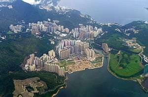
Tseung Kwan O New Town (Chinese: 將軍澳新市鎮) is one of the nine new towns in Hong Kong, built mainly on reclaimed land in the northern half of Junk Bay (also known as Tseung Kwan O), after which it is named.
Development of the new town was approved in 1982, with the initial population intake occurring in 1988. As of 2016, the town is home to around 372,000 residents. The total development area of Tseung Kwan O, including its industrial estate, is about 10.05 square kilometres (3.88 sq mi), with a planned population of 445,000.[1] Major residential areas within the new town include Tsui Lam, Po Lam, Hang Hau, Tseung Kwan O Town Centre, Tiu Keng Leng (formerly known as Rennie's Mill) and Siu Chik Sha.
Administratively, the new town belongs to Sai Kung District in the southeastern New Territories, although it is often incorrectly regarded as part of Kowloon due to its close proximity to the city—the town is bordered by the urban township of Kwun Tong to its west.
History and urban development

The Hong Kong Government had been interested in developing a new town at Hang Hau because of its proximity to the urban area. The project was postponed for a long time owing to the extensive scale of reclamation in the bay, which is rather deep. The project finally took off under the name of Tseung Kwan O in 1983, when the development of the new town's Phase I was endorsed by the Governor-in-Council.[2] This was followed by the decision to proceed with Phase II, which entailed further reclamation and the clearance of the Kuomintang refugee village at Rennie's Mill (later renamed Tiu Keng Leng), with a view to increase the planned population from 175,000 to 325,000.[2] The first families moved in to the new town in 1988 when public housing at the Head of the Bay (Po Lam Estate) was completed.[2].
The New Town was developed in three phases. The first phase encompasses Northern Tseung Kwan O, which includes Po Lam MTR Station and Hang Hau Station, while the second and third phase comprise Southern Tseung Kwan O, which includes Tseung Kwan O Station (Town Centre) and Tiu Keng Leng Station.
- Phase I – Hang Hau, Po Lam, Siu Chik Sha, Tsui Lam
- Phase II – Town Centre North, Tiu Keng Leng
- Phase III – Town Centre South, Pak Shing Kok, Tai Chik Sha
The design of the new town was highly transit-oriented. Developments centred along the MTR-corridor, with more than 80% of the population living within five minutes of an MTR station, with huge residential complexes surrounding the MTR stations. As most of the residential complexes surrounds the MTR station, there are huge parks in the rest of Tseung Kwan O New Town.
Demographics
The 2016 Population By-census records the population of Tseung Kwan O New Town at 398,479, a 7.12% increase from 2011.[3]
Private Residence
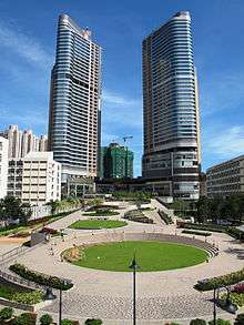

The Wings (Chinese: 天晉) is another private housing estate, with shopping mall PopCorn and two hotels, in Tsueng Kwan O. The estate is solely developed by Sun Hung Kai Properties, comprising 4 buildings with total of 784 flats completed in 2012[4][5][6]
Tseung Kwan O Plaza (Chinese: 將軍澳廣場) is a private housing estate and shopping mall near MTR Tseung Kwan O Station. It was developed by Nan Fung Group in 2004. It comprises 8 high-rise buildings with a total of 2880 units.[7]
Park Central (Chinese: 將軍澳中心) is a private housing estate and shopping mall near MTR Tseung Kwan O Station. It was developed by Sun Hung Kai Properties. It comprises 10 high-rise buildings.[8]
Economy
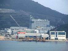
Tseung Kwan O Industrial Estate is located in the southeast of the town. The estate is where a number of mass media outlets locate their headquarters at, including TVB City, the headquarters of Hong Kong's largest television broadcaster, and news agencies like Apple Daily and Sing Tao Daily. It is also home to the data centres of various multinational corporations. The mass housing development LOHAS Park is built just north of the industrial estate.
Bus routes 797M (NWFB) and 298E (KMB) connect the industrial estate to southern Tseung Kwan O. A spur line of the MTR's Tseung Kwan O Line to the LOHAS Park station was completed in July 2009 and provides easy access to the industrial estate from Kowloon and Hong Kong Island.
Shopping complexes
Tseung Kwan O has several major shopping complexes. The largest shopping centre is Metro City (Chinese: 新都城) located by Po Lam MTR Station.
Hang Hau MTR Station is surrounded by an extensive network of mid-sized shopping arcades linked by footbridges. The mainstay of this multifarious complex is East Point City.
Tseung Kwan O Town Centre (Tseung Kwan O MTR Station) is home to Park Central, PopCorn, and Tseung Kwan O Plaza.
Infrastructure
Transport
Tseung Kwan O is linked to urban Hong Kong Island by the namesake Tseung Kwan O Line of the MTR metro system. The commutes from Po Lam and Tiu Keng Leng to Central District take 31 and 24 minutes, respectively. Currently the line calls at five stations in the new town:
Tiu Keng Leng Station is also the terminus of MTR's Kwun Tong Line. All MTR stations within the new town are either connected to or in the proximity of shopping centres and large private housing developments.
The new town is also well-covered by the local public bus and minibus network. Hong Kong's three major bus operators all have routes with termini in Tseung Kwan O. Kowloon Motor Bus, the major bus operator in the New Territories, serves mainly Po Lam and Hang Hau areas. Having successfully tendered for a package of bus routes serving southern Tseung Kwan O, New World First Bus now operates an extensive network serving Tiu Keng Leng, Tseung Kwan O Town Centre and most of the town's southern part. The new town is linked to the airport at Chek Lap Kok by a handful of Citybus routes.
Part of Route 7, the Tseung Kwan O Tunnel acts as the major road link between Tseung Kwan O and urban Kowloon. Other main roads leading to Tseung Kwan O include:
- Po Lam Road, connected to Kwun Tong.
- Hang Hau Road and Ying Yip Road, connected to Sai Kung and Clear Water Bay.
- Wan Po Road, connected to Tseung Kwan O Industrial Estate.
Healthcare
Tseung Kwan O Hospital is the only secondary care hospital within the new town boasting a 24-hour emergency department. Situated on the western slopes of Tseung Kwan O is Haven of Hope Hospital, where subacute medical care, comprehensive rehabilitation and long-term care is provided.
The two hospitals are supplemented by public healthcare facilities like the Tseung Kwan O Jockey Club General Out-patient Clinic and Po Ning Road Health Centre, as well as the numerous private physician practices scattered among the various residential areas in the new town.
Recreation
A public sports centre and a library are situated by the roundabout at the end of Tseung Kwan O Tunnel Road. Tseung Kwan O lacks a performing arts centre.
Tseung Kwan O Sports Ground was built for the 2009 East Asian Games. It was completed in early 2009 and will also host Hong Kong First Division League matches.
Tseung Kwan O Football Training Centre is being developed to deliver six state of the art pitches; three artificial and three natural. It is being funded by the Hong Kong Jockey Club, spear headed by Hong Kong Football Association, and constructed by Projexasia.

Photo gallery
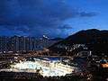 Tseung Kwan O Library at Dusk
 Tseung Kwan O Swimming Pool and Sports Centre.
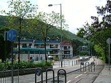 Tseung Kwan O Village
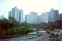 Tsui Lam Estate
See also
References
- ↑ Hong Kong: The Facts - New Towns, New Development Areas and Urban Developments
- 1 2 3 "Tseung Kwan O: Historical Background". Planning Department. Retrieved 2018-10-12.
- ↑ "District Profiles". 2016 Population By-census. Census and Statistics Department. Retrieved 2018-10-12.
- ↑ http://www.shkp.com/en-US/Pages/hkproperties-residential
- ↑ http://www.thewingsii.com.hk/
- ↑ http://ps.hket.com/project/239
- ↑ Official website of Tseung Kwan O Plaza Retrieved 2011-09-18
- ↑ http://www.park-central.com.hk/chi/home.html
External links
- District Council website
- Electoral Boundary Map 1
- Electoral Boundary Map 2
- Tseung Kwan O New Town
- The Website of Tseung Kwan O (Informal) – Chinese Version Only
Coordinates: 22°18′15″N 114°14′58″E / 22.3043°N 114.2494°E