Tseung Kwan O
| Tseung Kwan O | |
|---|---|
| Town | |
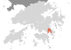 | |
| Country | Hong Kong |
| Region | New Territories |
| District | Sai Kung |
| Population (2011) | |
| • Total | 368,000 |
| Tseung Kwan O | |||||||||||||
| Traditional Chinese | 將軍澳 | ||||||||||||
|---|---|---|---|---|---|---|---|---|---|---|---|---|---|
| Simplified Chinese | 将军澳 | ||||||||||||
| |||||||||||||
Tseung Kwan O (also called Cheung Kwan O or Junk Bay) is a bay in Sai Kung District, New Territories, Hong Kong. In the northern tip of the bay lies the Tseung Kwan O Village.
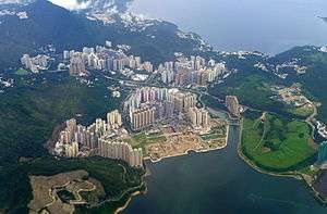
The Tseung Kwan O New Town, one of the nine new towns in Hong Kong, was mainly built on reclaimed land in the northern half of the bay. The current population as of 2011 is about 368,000.[1]
Name
In Cantonese, Tseung Kwan (將軍) means the "general" of an army, and O (澳) means "bay". Therefore, Tseung Kwan O literally means "general's Bay".
The exact origin of the name Tseung Kwan O is unknown, but it is said to be named in honour of a Ming Dynasty soldier who visited Tseung Kwan O at some point. Another theory is that the name was chosen in the 17th century, when naval battles were fought against pirates from Japan at Tseung Kwan O. Yet another theory is that the pronunciation of "將軍" can sound like "Junk Wan" to the ears of English speakers; wan is also a transliteration of the Chinese word for "bay" (灣).
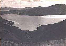
The current town center of Tseung Kwan O stands on reclaimed land. The English name Junk Bay was said to be derived from the existence of junks in the bay, and the reclamation land based on the landfill . The first landfill was opened in 1978, decades after Junk Bay was named.[2] The Fat Tong Chau (Junk Island) is in the southeastern part of the bay.
History and geography
The bay is near the eastern mouth of Hong Kong's Victoria Harbour. A local gazette, Genuine record of Guangdong province (Chinese traditional: 粵大記), clearly contained the place name: 將軍澳 (Chinese characters of Tseung Kwan O). A genuine record of Guangdong province was published during the Ming Dynasty: Residents inhabited Tseung Kwan O area then.
Before the development of the new town, the area around the bay was occupied by fishing towns and villages. Settlements in the area began as early as in the 13th century. Major settlements, however, did not occur until the late 16th century when small fishing villages were founded in the area. Hang Hau quickly emerged into a market town and became the most populated and prosperous place in the whole of Clear Water Bay Peninsula; it continued for the next few centuries as such.[3] Other towns and villages include Rennie's Mill (Tiu Keng Leng), Hang Hau and Yau Yue Wan. Rennie's Mill was where Kuomintang loyalists were settled following the end of the Chinese civil war, and Hang Hau had a ship-building industry.
The Hong Kong Government had been interested in developing a new town at Hang Hau because of its proximity to the urban area. The project was postponed for a long time owing to the extensive scale of reclamation in the bay, which is rather deep. It finally started under the name of Tseung Kwan O. The area of Tseung Kwan O is about 1,790 ha, with a projected population of 490,000 upon completion.[4]
Now Tseung Kwan O has been developed to be including four main areas: Po Lam, Hang Hau, Tseung Kwan O and Tiu Keng Leng.
Climate
| Climate data for Tseung Kwan O (1992–2016) | |||||||||||||
|---|---|---|---|---|---|---|---|---|---|---|---|---|---|
| Month | Jan | Feb | Mar | Apr | May | Jun | Jul | Aug | Sep | Oct | Nov | Dec | Year |
| Record high °C (°F) | 28.0 (82.4) |
28.5 (83.3) |
29.6 (85.3) |
31.8 (89.2) |
34.4 (93.9) |
35.5 (95.9) |
36.4 (97.5) |
37.6 (99.7) |
35.8 (96.4) |
34.5 (94.1) |
32.1 (89.8) |
28.8 (83.8) |
37.6 (99.7) |
| Average high °C (°F) | 18.4 (65.1) |
19.0 (66.2) |
20.9 (69.6) |
24.6 (76.3) |
28.0 (82.4) |
30.2 (86.4) |
31.3 (88.3) |
31.3 (88.3) |
30.2 (86.4) |
28.0 (82.4) |
24.6 (76.3) |
20.4 (68.7) |
25.6 (78.1) |
| Daily mean °C (°F) | 15.4 (59.7) |
16.2 (61.2) |
18.3 (64.9) |
22.0 (71.6) |
25.4 (77.7) |
27.5 (81.5) |
28.3 (82.9) |
28.0 (82.4) |
27.0 (80.6) |
24.8 (76.6) |
21.5 (70.7) |
17.1 (62.8) |
22.6 (72.7) |
| Average low °C (°F) | 13.0 (55.4) |
14.1 (57.4) |
16.3 (61.3) |
20.1 (68.2) |
23.4 (74.1) |
25.5 (77.9) |
25.9 (78.6) |
25.6 (78.1) |
24.8 (76.6) |
22.5 (72.5) |
19.1 (66.4) |
14.5 (58.1) |
20.4 (68.7) |
| Record low °C (°F) | 2.1 (35.8) |
4.3 (39.7) |
7.0 (44.6) |
9.8 (49.6) |
15.1 (59.2) |
19.9 (67.8) |
21.9 (71.4) |
22.4 (72.3) |
19.2 (66.6) |
14.4 (57.9) |
8.9 (48) |
4.0 (39.2) |
2.1 (35.8) |
| Average precipitation mm (inches) | 33.2 (1.307) |
50.5 (1.988) |
78.1 (3.075) |
151.5 (5.965) |
304.0 (11.969) |
508.8 (20.031) |
382.8 (15.071) |
424.2 (16.701) |
302.8 (11.921) |
95.0 (3.74) |
47.4 (1.866) |
28.3 (1.114) |
2,406.6 (94.748) |
| Average relative humidity (%) | 73 | 80 | 82 | 86 | 86 | 86 | 83 | 85 | 81 | 75 | 74 | 70 | 80 |
| Source: Hong Kong Observatory[5] | |||||||||||||
Development of Tseung Kwan O
In 1983, development of Phase I of the New Town to an initial population of about 175,000 was formally endorsed. By 1986, construction of the two tubes of Tseung Kwan O Tunnel began, which provided potential for further increasing the population of the New Town. To maximize the utilization of the road infrastructure and to meet the demand for land for public housing, the Government decided that the New Town should include a Phase II development, with an increase in the projected population to about 325,000. To cater for redevelopment of the Tiu Keng Leng Cottage Area and to provide land for development of Tseung Kwan O Industrial Estate and deep waterfront industries, in 1988, the Government further decided to proceed with Phase III development of the New Town for about 490,000 people.[6][7]
Education
A new campus of the French International School of Hong Kong as well as the new Shrewsbury International School Hong Kong are scheduled to open in 2018 in Areas 67 and 85 of Tseung Kwan O respectively.[8]
Photo gallery
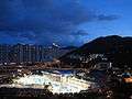 Tseung Kwan O Library at Dusk
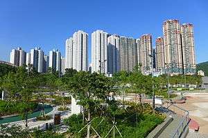 High density buildings in Hang Hau
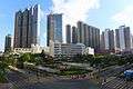 Tseung Kwan O Town Centre
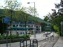 Tseung Kwan O Village
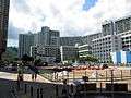 Po Lam Estate
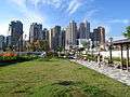
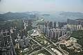 Above Tseung Kwan O
See also
References
| Wikimedia Commons has media related to Tseung Kwan O. |
- ↑ "Archived copy". Archived from the original on 2007-02-11. Retrieved 2007-02-10.
- ↑ Waste management in Hong Kong
- ↑ "Historical Background". www.pland.gov.hk.
- ↑ "Geographical Location". www.pland.gov.hk.
- ↑ "Monthly Means of Meteorological Elements for Tseung Kwan 0, 1992-2015". Hong Kong Observatory. Retrieved February 8, 2017.
- ↑ "Planning Department – Tseung Kwan O". www.pland.gov.hk.
- ↑ "Government Planned Development". www.pland.gov.hk.
- ↑ "Tseung Kwan O." French International School of Hong Kong. Retrieved on February 10, 2017. "Area 67, Tseung Kwan O, Hong Kong"