Troy Township, Geauga County, Ohio
| Troy Township, Geauga County, Ohio | |
|---|---|
| Township | |
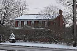 Fox-Pope Farmhouse, built 1820 | |
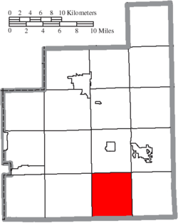 Location of Troy Township in Geauga County | |
| Coordinates: 41°23′0″N 81°9′2″W / 41.38333°N 81.15056°WCoordinates: 41°23′0″N 81°9′2″W / 41.38333°N 81.15056°W | |
| Country | United States |
| State | Ohio |
| County | Geauga |
| Area | |
| • Total | 25.8 sq mi (66.7 km2) |
| • Land | 25.1 sq mi (64.9 km2) |
| • Water | 0.7 sq mi (1.8 km2) |
| Elevation[1] | 1,220 ft (372 m) |
| Population (2010) | |
| • Total | 2,801 |
| • Density | 112/sq mi (43.2/km2) |
| Time zone | UTC-5 (Eastern (EST)) |
| • Summer (DST) | UTC-4 (EDT) |
| FIPS code | 39-77574[2] |
| GNIS feature ID | 1086162[1] |
Troy Township is one of the sixteen townships of Geauga County, Ohio, United States. As of the 2010 census the population was 2,801,[3] up from 2,567 at the 2000 census.[4]
Geography
Located in the southern part of the county, it borders the following townships:
- Burton Township - north
- Middlefield Township - northeast corner
- Parkman Township - east
- Nelson Township, Portage County - southeast corner
- Hiram Township, Portage County - south
- Mantua Township, Portage County - southwest corner
- Auburn Township - west
- Newbury Township - northwest corner
No municipalities are located in Troy Township, although the unincorporated community of Welshfield is located in the township's center.
Name and history
It is one of seven Troy Townships statewide.[5]
Government
The township is governed by a three-member board of trustees, who are elected in November of odd-numbered years to a four-year term beginning on the following January 1. Two are elected in the year after the presidential election and one is elected in the year before it. There is also an elected township fiscal officer,[6] who serves a four-year term beginning on April 1 of the year after the election, which is held in November of the year before the presidential election. Vacancies in the fiscal officership or on the board of trustees are filled by the remaining trustees.
References
- 1 2 "US Board on Geographic Names". United States Geological Survey. 2007-10-25. Retrieved 2008-01-31.
- ↑ "American FactFinder". United States Census Bureau. Retrieved 2008-01-31.
- ↑ "Geographic Identifiers: 2010 Demographic Profile Data (G001): Troy township, Geauga County, Ohio". American Factfinder. U.S. Census Bureau. Retrieved January 13, 2017.
- ↑ Geauga County, Ohio — Population by Places Estimates Archived 2013-12-02 at the Wayback Machine. Ohio State University, 2007. Accessed 15 May 2007.
- ↑ "Detailed map of Ohio" (PDF). United States Census Bureau. 2000. Retrieved 16 February 2007.
- ↑ §503.24, §505.01, and §507.01 of the Ohio Revised Code. Accessed 30 April 2009.
External links
Municipalities and communities of Geauga County, Ohio, United States | ||
|---|---|---|
| City | 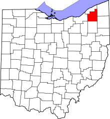 | |
| Villages | ||
| Townships | ||
| CDPs | ||
| Unincorporated communities | ||
| Footnotes | ‡This populated place also has portions in an adjacent county or counties | |