Trostberg
| Trostberg | ||
|---|---|---|
| ||
 Trostberg Location of Trostberg within Traunstein district 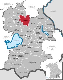 | ||
| Coordinates: 48°1′N 12°33′E / 48.017°N 12.550°ECoordinates: 48°1′N 12°33′E / 48.017°N 12.550°E | ||
| Country | Germany | |
| State | Bavaria | |
| Admin. region | Oberbayern | |
| District | Traunstein | |
| Government | ||
| • Mayor | Karl Schleid (CSU) | |
| Area | ||
| • Total | 51.36 km2 (19.83 sq mi) | |
| Elevation | 493 m (1,617 ft) | |
| Population (2017-12-31)[1] | ||
| • Total | 11,132 | |
| • Density | 220/km2 (560/sq mi) | |
| Time zone | CET/CEST (UTC+1/+2) | |
| Postal codes | 83308 | |
| Dialling codes | 08621 | |
| Vehicle registration | TS | |
| Website | www.trostberg.de | |

Trostberg is a town in the district of Traunstein, in Bavaria, Germany. It is situated on the river Alz, 19 km northwest of Traunstein. As with other 'old towns' in the region, it is a popular local tourist spot.
Economy
About 1,400 people are employed at the Chemiepark Trostberg, a large chemical industrial area near the town. The two main companies are AlzChem and BASF Bauchemie (construction chemistry).[2] The Chemiepark Trostberg originated from a calcium cyanamide production plant, founded in 1908. Between 1978 and 2000, the company was called SKW Trostberg AG.[3]
History
During World War II, a subcamp of Dachau concentration camp was located in the town.[4]
References
- ↑ "Fortschreibung des Bevölkerungsstandes". Bayerisches Landesamt für Statistik und Datenverarbeitung (in German). September 2018.
- ↑ Stadt Trostberg, Wirtschaftsstandort
- ↑ History of AlzChem AG Archived 2014-11-04 at the Wayback Machine.
- ↑ "Archived copy". Archived from the original on 2009-02-09. Retrieved 2008-11-01.
This article is issued from
Wikipedia.
The text is licensed under Creative Commons - Attribution - Sharealike.
Additional terms may apply for the media files.