Grassau, Bavaria
| Grassau, Bavaria | ||
|---|---|---|
 Grassau | ||
| ||
 Grassau, Bavaria Location of Grassau, Bavaria within Traunstein district 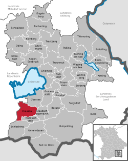 | ||
| Coordinates: 47°46′44″N 12°27′00″E / 47.77889°N 12.45000°ECoordinates: 47°46′44″N 12°27′00″E / 47.77889°N 12.45000°E | ||
| Country | Germany | |
| State | Bavaria | |
| Admin. region | Oberbayern | |
| District | Traunstein | |
| Government | ||
| • Mayor | Rudi Jantke (SPD) | |
| Area | ||
| • Total | 35.76 km2 (13.81 sq mi) | |
| Elevation | 538 m (1,765 ft) | |
| Population (2017-12-31)[1] | ||
| • Total | 6,818 | |
| • Density | 190/km2 (490/sq mi) | |
| Time zone | CET/CEST (UTC+1/+2) | |
| Postal codes | 83224 | |
| Dialling codes | 08641 | |
| Vehicle registration | TS | |
| Website | www.grassau.de | |

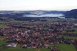
Grassau is a market town in the district of Traunstein in Bavaria in Germany. It is located south of lake Chiemsee in the valley of the Tiroler Ache.
Subdivisions
Grassau consists of the districts of
- Grassau
- Mietenkam
- Rottau
- Aich
- Au
- Brandstätt
- Einöde
- Fahrnpoint
- Grafing
- Guxhausen
- Hindling
- Klaus
- Kucheln
- Mauthäusl
- Nachmühl
- Nußbaum
- Obermoosbach
- Reifing
- Reit
- Strehtrumpf
- Untermoosbach
- Viehhausen
- Weiher
References
- ↑ "Fortschreibung des Bevölkerungsstandes". Bayerisches Landesamt für Statistik und Datenverarbeitung (in German). September 2018.
This article is issued from
Wikipedia.
The text is licensed under Creative Commons - Attribution - Sharealike.
Additional terms may apply for the media files.