Trockenborn-Wolfersdorf
| Trockenborn-Wolfersdorf | |
|---|---|
 Trockenborn-Wolfersdorf Location of Trockenborn-Wolfersdorf within Saale-Holzland-Kreis district  | |
| Coordinates: 50°47′17″N 11°41′42″E / 50.78806°N 11.69500°ECoordinates: 50°47′17″N 11°41′42″E / 50.78806°N 11.69500°E | |
| Country | Germany |
| State | Thuringia |
| District | Saale-Holzland-Kreis |
| Municipal assoc. | Hügelland/Täler |
| Government | |
| • Mayor | Dieter Hoog |
| Area | |
| • Total | 18.93 km2 (7.31 sq mi) |
| Elevation | 300 m (1,000 ft) |
| Population (2017-12-31)[1] | |
| • Total | 606 |
| • Density | 32/km2 (83/sq mi) |
| Time zone | CET/CEST (UTC+1/+2) |
| Postal codes | 07646 |
| Dialling codes | 036428 |
| Vehicle registration | SHK, EIS, SRO |
| Website | www.huegelland-taeler.de |
Trockenborn-Wolfersdorf is a municipality in the district Saale-Holzland, in Thuringia, Germany.
Wolfersdorf Castle, a hunting lodge of the Dukes of Saxe-Altenburg, received its name Schloss Froehliche Wiederkunft ("Palace of Happy Returning") when its first owner, John Frederick I, Elector of Saxony, returned there in 1552 to meet his family after a five years absence as a war prisoner. The last Sovereign, Ernst II, Duke of Saxe-Altenburg, died there in 1955 as a citizen of East Germany.
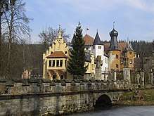
Wolfersdorf Castle ("Palace of Happy Returning")
References
This article is issued from
Wikipedia.
The text is licensed under Creative Commons - Attribution - Sharealike.
Additional terms may apply for the media files.