Freienorla
| Freienorla | |
|---|---|
 Freienorla Location of Freienorla within Saale-Holzland-Kreis district 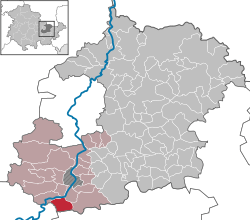 | |
| Coordinates: 50°46′10″N 11°32′34″E / 50.76944°N 11.54278°ECoordinates: 50°46′10″N 11°32′34″E / 50.76944°N 11.54278°E | |
| Country | Germany |
| State | Thuringia |
| District | Saale-Holzland-Kreis |
| Municipal assoc. | Südliches Saaletal |
| Government | |
| • Mayor | Ulrich Eismann |
| Area | |
| • Total | 6.81 km2 (2.63 sq mi) |
| Elevation | 180 m (590 ft) |
| Population (2017-12-31)[1] | |
| • Total | 331 |
| • Density | 49/km2 (130/sq mi) |
| Time zone | CET/CEST (UTC+1/+2) |
| Postal codes | 07768 |
| Dialling codes | 036423 |
| Vehicle registration | SHK, EIS, SRO |
| Website | www.freienorla.de |
Freienorla is located in the German state of Thuringia. Although quite small and obscure, the municipality is known locally for its Gothic church as well as its lower mill, a watermill facility thought to be built in the tenth century. The Orlaban railroad has a station located in Freienorla. Neighboring towns include Jena and Eisenberg. Freienorla is located 145 miles from the capital of Berlin.
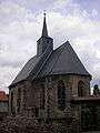 Gothic church
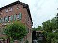 Lower mill
References
External links
This article is issued from
Wikipedia.
The text is licensed under Creative Commons - Attribution - Sharealike.
Additional terms may apply for the media files.