Albersdorf, Thuringia
| Albersdorf | |
|---|---|
 Albersdorf Location of Albersdorf within Saale-Holzland-Kreis district 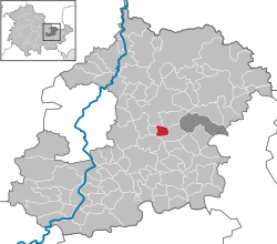 | |
| Coordinates: 50°54′11″N 11°46′28″E / 50.90306°N 11.77444°ECoordinates: 50°54′11″N 11°46′28″E / 50.90306°N 11.77444°E | |
| Country | Germany |
| State | Thuringia |
| District | Saale-Holzland-Kreis |
| Municipal assoc. | Bad Klosterlausnitz |
| Government | |
| • Mayor | Torsten Döhler |
| Area | |
| • Total | 2.85 km2 (1.10 sq mi) |
| Elevation | 355 m (1,165 ft) |
| Population (2017-12-31)[1] | |
| • Total | 285 |
| • Density | 100/km2 (260/sq mi) |
| Time zone | CET/CEST (UTC+1/+2) |
| Postal codes | 07646 |
| Dialling codes | 036692 |
| Vehicle registration | SHK, EIS, SRO |
| Website | www.bad-klosterlausnitz.de |
Albersdorf is a municipality in the Saale-Holzland district of Thuringia, Germany.
Geography
The farming town of Albersdorf lies in the middle of the Thuringian Holzland, about 15 km east of the city center of Jena. The nearest exits on the A 4 (an east-west axis) and the A 9 (a north-south axis) are about 5 km apart from each other, which results in a favorable traffic situation for Albersdorf.
References
| Authority control |
|---|
This article is issued from
Wikipedia.
The text is licensed under Creative Commons - Attribution - Sharealike.
Additional terms may apply for the media files.