William G. Milliken State Park and Harbor
| William G. Milliken State Park and Harbor | |
|---|---|
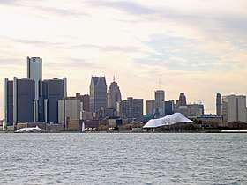 View of the state park from across the Detroit River | |
 Location in Michigan | |
| Type | Michigan State Park |
| Location |
Detroit International Riverfront Downtown Detroit, Michigan |
| Coordinates | 42°19′55″N 83°01′42″W / 42.33194°N 83.02833°WCoordinates: 42°19′55″N 83°01′42″W / 42.33194°N 83.02833°W [1] |
| Area | 31 acres (13 ha) |
| Elevation | 584 feet (178 m) [1] |
| Created | 2004 (renamed in 2009) |
| Operated by | Michigan Department of Natural Resources |
| Website | Milliken State Park and Harbor |
The William G. Milliken State Park and Harbor (formerly named Tri-Centennial State Park and Harbor) is a state park in Michigan, located just east of downtown Detroit along a portion of the city's International Riverfront on the Detroit River. The park's 31 acres (13 ha) include wetlands, paved trails, and a 52-slip harbor of refuge.[2] A 63-foot (19 m) conical brick lighthouse tower, designed as a scaled-down replica of the Tawas Point Light, marks the harbor entrance.[3]
History
The park consists of the former city-owned St. Aubin Park and Marina and an adjacent reclaimed brownfield. The park area was taken over by the Michigan Department of Natural Resources in 2004 as Tri-Centennial State Park to commemorate the founding of Fort Detroit in 1701. It was the state's first to be situated in an urban area. Phase I of the park's development, which included refurbishing the marina and construction of the light tower, opened on May 20, 2004. Construction of the 6-acre (2.4 ha) Phase II, or expansion, phase of the project began in summer 2008 and concluded in summer 2009. The Phase II project encompassed a parcel of post-industrial property adjacent to Rivard Plaza.[2] On October 22, 2009, Tri-Centennial State Park was renamed in honor of Governor William G. Milliken.[4] The Lowlands section of the park was officially opened to the public on December 3, 2009.[3]
Ecology
Much of the William G. Milliken State Park has been redeveloped as restoration wetlands, intended to mimic the riverine wetlands that once bordered the Detroit River. The Michigan DNR hopes that these wetlands will be an attractive location for migratory birds. Ninety-seven percent of the former Detroit River wetlands have been lost to development; the de-development of Detroit in the 2000s created an opportunity for wetlands restoration.[4]
Access
The William G. Milliken State Park's official address is 1900 Atwater Street, on the near east side of Detroit and adjacent to the Jefferson Avenue corridor.[4] The City of Detroit finished construction on what is called the "Dequindre Extension" in May 2010. This new section of Milliken State Park connects the park to the Dequindre Cut.[5]
Activities and amenities
The park offers shoreline fishing, a picnic area with sail-covered pavilions, and a 52-slip harbor with transient and seasonal tie-ups.[2]
References
- 1 2 "Saint Aubin Marina". Geographic Names Information System. United States Geological Survey.
- 1 2 3 "William G. Milliken State Park and Harbor". Michigan Department of Natural Resources. Retrieved December 7, 2009.
- 1 2 "Milliken State Park and Harbor". Detroit RiverFront Conservancy. Retrieved July 16, 2018.
- 1 2 3 Michigan Department of Natural Resources (December 3, 2009). "Milliken State Park is officially open" (Press release). Retrieved July 16, 2018.
- ↑ "Dequindre Cut". Detroit RiverFront Conservancy. Retrieved July 16, 2018.
External links
| Wikimedia Commons has media related to Milliken State Park and Harbor. |
- Milliken State Park and Harbor Michigan Department of Natural Resources
- Milliken State Park and Harbor Map Michigan Department of Natural Resources