Treat, Algeria
| Treat | |
|---|---|
| Nickname(s): Tickity, tat | |
 | |
 Treat | |
| Coordinates: 36°53′51″N 7°25′41″E / 36.89750°N 7.42806°E | |
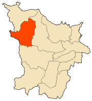
| Country | Algeria |
| Province | Annaba |
| Population (2008)[1] | |
| • Total | 6,076 |
| Time zone | UTC+1 (West Africa Time) |
Treat, Algeria is a town in north-eastern Algeria.
The municipality of Treat is located to the west of the wilaya of Annaba, at 36.89747n , 7.42802. Treat is bordered to the south by the sandy plain of the Oued el Kebir (complex of wetlands of Guerbes-Senhadja) and to the north by the forest massif of the peninsula of the Edough.
The central part of the municipality consists of agglomeration, crops and pastures
Twin cities
References
| Annaba District | 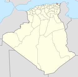 | |
|---|---|---|
| Aïn El Berda District | ||
| El Hadjar District | ||
| Berrahal District | ||
| Chetaïbi District | ||
| El Bouni District | ||
This article is issued from
Wikipedia.
The text is licensed under Creative Commons - Attribution - Sharealike.
Additional terms may apply for the media files.