El Bouni District
| El Bouni District | |
|---|---|
| District | |
 | |
| Coordinates: Coordinates: 36°51′16.9″N 7°44′33.1″E / 36.854694°N 7.742528°E | |
| Country |
|
| Province | Annaba Province |
| County seat | El Bouni |
| Area | |
| • Total | 36 sq mi (93 km2) |
| Population (2008) | |
| • Total | 125,265 |
| • Density | 3,490/sq mi (1,347/km2) |
| Time zone | UTC+1 (CET) |
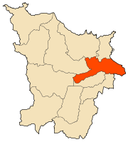
The El Bouni district is an Algerian administrative district in the Annaba province. Its chief town is located on the eponymous town of El Bouni.[1][2]
Communes
The daira is composed of only one commune: El Bouni.
References
- ↑ "El Bouni District". OpenSteetMap. OpenSteetMap. Retrieved 6 May 2018.
- ↑ "accès zone industrielle, Annaba, El Bouni District, El Bouni". postboxmap. Retrieved 6 May 2018.
| Annaba District | 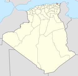 | |
|---|---|---|
| Aïn El Berda District | ||
| El Hadjar District | ||
| Berrahal District | ||
| Chetaïbi District | ||
| El Bouni District | ||
This article is issued from
Wikipedia.
The text is licensed under Creative Commons - Attribution - Sharealike.
Additional terms may apply for the media files.