Transportation in Indianapolis
Indianapolis is served by many different kinds of transportation.
History

Indianapolis was founded on the White River under an incorrect assumption that it would serve as a major transportation artery, but the river proved difficult to navigate and too shallow during much of the year.[1] After the steamboat Robert Hanna ran aground along the river in 1831, no steamboat successfully returned to Indianapolis. Flatboats continued to transport goods along a portion of the river until new dams impeded their ability to navigate its waters.[2]
The first major federally funded highway in the U.S., the National Road, reached Indianapolis in 1836,[1] followed by the railroad in 1847. By 1850, eight railroads converged in the city, ending its isolation from the rest of the country and ushering in a new era of growth.[3] Indianapolis Union Station opened in the Wholesale District on September 20, 1853 as the world's first union station.[4] Citizen's Street and Railway Company was established in 1864, operating the city's first mule-drawn streetcar line.[5][6] By 1890, electric-powered streetcars began running.[7] Opened in 1904, the Indianapolis Traction Terminal was the largest interurban station in the world, handling 500 trains daily and 7 million passengers annually.[8] Ultimately doomed by the automobile, the terminal closed in 1941, followed by the streetcar system in 1957.[9]
Airports
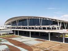
Indianapolis International Airport, identified as IND, is the largest airport in Indiana and serves the Indianapolis Metropolitan Area. A new midfield terminal was built in 2008, with 40 gates and two concourses. There are also plans for a third parallel runway south of I-70.
FedEx Express, a cargo airline, operates a national hub out of IND and is the second largest hub operation in the world behind only the Superhub in Memphis. FedEx plans to continue expanding the hub along Interstate 70 or possibly where the old passenger terminal remains. Adding onto the FedEx ramp will allow more wide-body aircraft and more direct flights from IND to FedEx hubs in Europe and Asia.
Cargolux, which flies to Chicago O'Hare, Los Angeles, and Luxembourg, also operates out of IND.
Highways
Interstate Highways
Several interstates serve the Indianapolis area:


U.S. Highways
State roads
Mass transit

The Indianapolis Public Transportation Corporation, known locally as IndyGo, provides public transportation for the city. IndyGo was established in 1975 after the city of Indianapolis took over privately owned Indianapolis Transit Systems, Inc. Prior to 1997, IndyGo was called Metro. Central Indiana Commuter Services (CICS), funded by IndyGo to reduce pollution, serves Indianapolis and surrounding counties.
Historically, Indianapolis had an extensive network of streetcar routes. In 1953, the last streetcars ran in the city. Trolleybuses made their last run in the city four years later in 1957, leaving the city with an all-bus transit system. The Downtown Indianapolis Streetcar Corp., a not-for-profit organization, is investigating the feasibility of a streetcar line to serve various downtown destinations.[10]
A report prepared by Purdue University indicates that buses running on a fuel containing 10 percent biodiesel are likely to help Indianapolis mass transit reduce pollution without compromising fuel economy. The report also suggests introducing more hybrid diesel-electric buses and a fuel containing 20 percent biodiesel (BD20) would further reduce emissions and petroleum consumption.[11]
IndyGo is in the process of planning for Phase 1 of the Red Line, a new bus rapid transit line running from Broad Ripple Village on the north side to the University of Indianapolis on the south side. This new line will provide more frequent service with fewer stops. Construction started in May 2018, with completion expected in early fall 2019.
People mover

The public-use Indiana University Health People Mover links the Indiana University School of Medicine with the medical centers of University Hospital, Riley Hospital for Children, Methodist Hospital, and related facilities on the campus of Indiana University – Purdue University Indianapolis (IUPUI). The people mover is sometimes inaccurately described as a monorail, but in fact rides on dual concrete beams with the guideway as wide as the vehicle.
Intercity transportation
Amtrak, the national passenger rail system, provides service to Indianapolis at the Indianapolis Union Station. Amtrak provides the tri-weekly service of the Cardinal to Chicago, New York City, and Washington, D.C. and the Hoosier State to Chicago on days the Cardinal does not operate.
Greyhound Lines operates a bus terminal at Union Station downtown. Megabus also runs from downtown Indianapolis, stopping on North Alabama Street adjacent to the Indianapolis City Market.
Transportation issues
Although Indianapolis has managed to sustain a relatively low amount of traffic congestion for a city of its population, this is mostly because the city covers 365 square miles (950 km2),[12] an area much larger than most cities with roughly 840000 people. Indianapolis's low population density might also be the reason the city has yet to further develop its mass transit bus system or a heavy or light rail network. Among urbanized areas with 1,000,000 population or greater in the United States, Indianapolis ranked tenth in freeway lane miles per 1,000 population and eighth in freeway-equivalent miles per 1,000 population.[13]
As the 12th-largest city in the U.S., Indianapolis has repeatedly been ranked below 40th in mass transit availability. However at recent city, county, metropolitan, and statewide meetings, the idea of a heavy rail transportation service has been seriously considered. It would be a four rail system originating at downtown and stretching north, northeast, east, southeast, south, southwest, west, and northwest to the city's suburban areas. The system would be called IndyGo.
Some complaints include:[14]
- the bus-only city mass transit system; the absence of rapid transit and light rail.
- the undue emphasis on automobile travel in city planning; the lack of sidewalks and bike paths.
- excessive automobile usage resulting in environmental degradation (specifically air pollution), as evidenced in the city's often poor air quality
- the lack of cross-town bus routes, forcing bus riders to travel downtown to cross from one side of the city to another, often doubling or tripling what the trip distance would have been with a direct route.
- the "lack of vision" in building a transportation network based entirely on non-renewable resources and old technology
- the paucity of scheduled bus routes, often forcing riders to choose between arriving at a destination extremely early, or late.
- the lack of night bus services, which forces those who work late shifts to find other ways to get around. These can be much more expensive.
- the fiscal costs of building (for instance liens), repairing, and replacing roads
There are other concerns over a lack of safe walking paths in many areas of the city. Many suburbs which were incorporated in the 1960s and 1970s are now relatively near the center of the city, and don’t have sidewalks. This often forces pedestrians to navigate a narrow road shoulder near high-speed automobile traffic.
References
- 1 2 Baer, p. 11, and Hyman, p. 34.
- ↑ Brown, p. 20, and Edward A. Leary (1971). Indianapolis: The Story of a City. Indianapolis: Bobbs-Merrill. p. 35.
- ↑ Bodenhamer and Barrows, p. 1480; Brown, pp. 34 and 52–53; Hale, p. 21; and Indianapolis, A Walk Through Time, p. 13.
- ↑ "Indianapolis Union Railroad Station". Discover Our Shared Heritage Travel Itinerary. Washington, D.C.: National Park Service. Retrieved August 11, 2015.
- ↑ Brown, p. 50.
- ↑ Sulgrove, pp. 134, 424–26.
- ↑ Hale, p. 54.
- ↑ "Transportation in Indianapolis: then and now". Indianapolis Public Transportation Corporation. Archived from the original on August 26, 2014. Retrieved August 28, 2014.
- ↑ O'Malley, Chris (August 27, 2011). "Backer seek support for 2-mile streetcar line downtown". Indianapolis Business Journal. Retrieved February 7, 2016.
- ↑ "IBJ.com Story Detail". Ibj.com. Retrieved 2008-11-06.
- ↑ "Emerging Energy News: Purdue: Biodiesel cuts carbon emission from buses". Energycurrent.com. Archived from the original on 2008-09-22. Retrieved 2008-11-06.
- ↑ The 2005 Urban Mobility Report Archived 2008-05-16 at the Wayback Machine.
- ↑ The Public Purpose Highway & Motorway Fact Book - Lane Miles per Capita 1999:US Urbanized Areas over 1,000,000
- ↑ Indianapolis Transportation Woes