Highway 5 (Israel)
| |
|---|---|
| כביש 5 | |
| Cross Samaria Highway | |
 | |
| Route information | |
| Length | 37 km (23 mi) |
| Major junctions | |
| West end | Tel Aviv (Glilot Junction) |
| |
| East end | Ariel |
| Location | |
| Major cities | Ramat HaSharon, Hod HaSharon, Petah Tikva, Rosh HaAyin, |
| Highway system | |
| Highways | |

Highway 5, Route 5, or the Trans-Samaria Highway (Hebrew: כביש חוצה שומרון, Kvish Hotze Shomron), is one of Israel's main highways, connecting the Mediterranean coast immediately north of Tel Aviv with the central Sharon plain and eastwards to Ariel and other Israeli settlements in the northern West Bank.
The name Highway 5 is commonly used to describe a section of the highway running from the road's western end at the Glilot Interchange until where it until it reaches the main entrance of Ariel. In this capacity it intersects and creates a connection between four important arterial freeways in the northern Tel Aviv area: The Coastal Highway (Highway 2), the Ayalon Highway (Highway 20), Geha Highway (Highway 4) and the Cross-Israel Highway (Highway 6).[1]
An alternate name for the entire highway is Kvish Hotze Shomron (Cross-Samaria highway) though often this name is used when referring specifically to the section of the road in the West Bank, i.e., past the Green Line, where it continues east towards the Jordan Valley in the West Bank. This section from the Green Line to its eastern end has also been dedicated as "Derekh Haim" (Haim's Road, but also "Way of Life") after the late Haim Landau, a former Israeli Minister of Transportation.
Highway 5 initially reached Rosh HaAyin inside the green line, and served mainly the densely populated Gush Dan area. In the West Bank, the main road was still the old Road 505, which since the events of the Second Intifada in 2000 is partially closed to Jewish transportation.[2] In the beginning of the 1990s, with the growth of Ariel and the settlements around it, arose the need for a more modern and wider road, than the single-lane low-quality Road 505. Therefore, Highway 5 was extended some 20 km to the east of the Green Line, ending almost within sight of Ariel and serving the largest block of the Israeli settlements in the northern West Bank counting about 50,000 people, as well as the Barkan Industrial Park. At the time, this section of Highway 5 was one of the biggest infrastructure projects that Israel had undertaken in the West Bank.[3][4] As of 2017 the road terminates at a roundabout at the Ariel junction where it merges into Road 505 which continues east past Ariel until Petza'el, which is located on Route 90, the north-south road parallel to the Israel-Jordan border in the Jordan Valley.
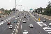
The western section of the highway consists of between 3 and 5 lanes in each direction, that reduce in number as the highway heads eastward. The westward section surrounding Gush Dan is as of 2017 one of the most congested in Israel.[5][6]
Highway 531, is a freeway which parallels Highway 5 runs approximately 5–6 km to the north, was opened in 2017, and also contains a rail system. A toll fast lane project is planned along Highway 5.[6]
Interchanges
| km | Name | Type | Meaning | Location | Road(s) Crossed |
|---|---|---|---|---|---|
| 0 | מחלף גלילות מערב (Glilot Ma'arav Interchange) |
West Glilot | Tel Aviv | Highway 2 | |
| 1 | מחלף גלילות מזרח (Glilot Mizrah Interchange) |
East Glilot | Tel Aviv | Ayalon Highway | |
| 1.7 | מחלף שדרות ירוב (Yariv Blvd. Interchange) eastbound only |
Glilot Army Base | Aharon Yariv Blvd. | ||
| 3.3 | מחלף הכפר הירוק (HaKfar HaYarok Interchange) |
Named after nearby HaKfar HaYarok |
Ramat HaSharon Tel Aviv |
Route 482 | |
| 5.8 | מחלף מורשה (Morasha Interchange) |
Named after location | Ramat HaSharon (Morasha quarter) |
Highway 4 | |
| 8 | מחלף תקווה (Tikva Interchange) |
Named after location | Petah Tikva, Yarkon Cemetery |
Zevulun Hammer Road | |
| 10.5 | מחלף ירקון (Yarkon Interchange) |
Named after nearby Yarkon River |
Petah Tikva Hod HaSharon |
Highway 40 | |
| 13.5 | מחלף קסם (Kessem Interchange) |
Named after nearby Kafr Qasim |
Rosh HaAyin | Highway 6 Route 444 | |
| 17 | מחלף ראש העין מזרח (Rosh HaAyin Mizrah Interchange) |
Rosh HaAyin East | Rosh HaAyin Kafr Qasim |
Road 5050 | |
| 19.4 | Green Line | ||||
| 21 | מחלף שער שומרון (Sha'ar Shomron Interchange) |
Samaria Gate | to Oranit, Elkana, stone quarry |
Route 505 | |
| 22 | Qasim Security Checkpoint | ||||
| 33 | מחלף ברוכין (Bruchin Interchange) |
Named after location | Bruchin Bruqin |
Route 446 | |
| 35 | מחלף ברקן (Barkan Interchange) |
Named after location | Barkan Barkan Industrial Park Ariel West Industrial Zone |
Road 4765 | |
| 37 | צומת גיתי (Gitai Junction) |
Named after Gitai Avisar |
Haris Revava |
Route 505 | |
| 40 | צומת אריאל (Ariel Junction) |
Named after location | Ariel Kifl Haris |
Route 505 | |
References
- ↑ Fodor's Essential Israel, Fodor's Travel Guides, Car Travel
- ↑ Hotze Shomron Reopens Without IDF Checkpoint, YNET, 24 Oct 2000
- ↑ "Kvish Hotze Shomron - Splits the People", Mapam Demonstrators Shouted at Dedication of Road, Maariv, 7 Aug 1987
- ↑ The Road is Not a Luxury, Maariv, 9 August 1987
- ↑ The Solution to Traffic Jams: Half a Road for Buses and Half for Rich People, TheMarker, 13 Sep 2016
- 1 2 Millions of Commuters Stuck on the Roads: 10 Worst Traffic Jams in Israel: Route 5: An Hour and a Half From Rosh Hayin to Tel-Aviv, Haaretz, 22 May 2017
| Roads |
| ||||
|---|---|---|---|---|---|
| Bus operators | |||||
| Rail transport |
| ||||
| Sea ports | |||||
| Aviation |
| ||||
| Cable cars | |||||
| By city | |||||
| Smart cards | |||||
Coordinates: 32°06′16″N 34°59′25″E / 32.10444°N 34.99028°E